Major Thanksgiving Storm to Impact US with Heavy Snow, Rain, and Lake-Effect Blizzard Conditions
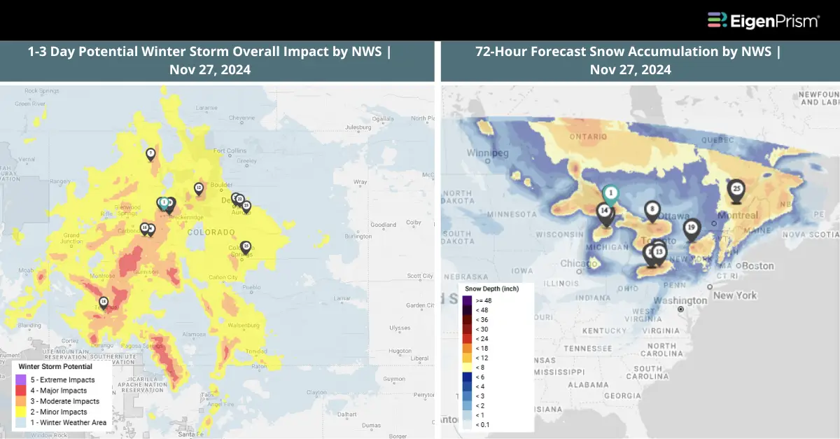
An intense lake-effect snow event will develop over the extended Thanksgiving holiday weekend, bringing near-blizzard conditions that could shut down highways and blanket towns with feet of snow. Meanwhile, a mix of rain and snow is forecast across the eastern third of the U.S. on Thanksgiving Day, potentially causing travel disruptions.
The storm will begin forming Wednesday afternoon over the southern Plains and Mississippi Valley after a dry start to the day in central parts of the country. Rain is expected to spread from the central U.S. into the Appalachians overnight. In some areas, rain may briefly mix with snow from Illinois to northern Pennsylvania and southern New York, creating slick roads and hazardous conditions for Thanksgiving travelers.
As snow tapers off in the Rockies, the storm system will push rain into the Midwest and Mississippi Valley by Wednesday afternoon, with showers expanding into the Ohio and Tennessee valleys by evening. By Thursday, rain will stretch from the Southeast to the Northeast, accompanied by light snow across the interior Northeast and northern New England. Wet, heavy snow is expected in the highest elevations of the Northeast, with a few inches of accumulation possible by late Thursday night in northern New York and New England.
While much of the US is expected to remain dry but cold on Thanksgiving, the East will bear the brunt of the storm. By Saturday, the system will begin moving out of the region, but Arctic air rushing over the unseasonably warm Great Lakes will trigger lake-effect snow. Some areas downwind of the lakes could see feet of snow accumulating over several days, extending into next week.
Gusty winds of 20 to 30 mph are expected across the Midwest on Friday, creating breezy conditions that may pose challenges for regional airports and further complicate post-Thanksgiving travel plans.
Major Thanksgiving Storm to Impact US: Actionable Analytics on EigenPrism
Forecast
All EigenPrism® users can assess the forecasts associated with this event using the following report templates:
US Winter Storm Forecast Template
The report template auto-updates with the latest available forecasts, which include:
- 72-hr Forecast Freezing Rain Accumulation
- 72-hr Forecast Snow Accumulation
- Potential Winter Storm Overall Impact
US Flood Forecast Report Template
The report template auto-updates with the latest available footprints, which include:
- WPC 3-Day Excessive Rainfall Outlook from NWS
- US Flood Outlook from NWS
- North America 3-day Flood Potential from Adiabat
- North America 5-day Flood Potential from Adiabat
Winter Severity Component Report Template
This report template consists of the summary level (Potential Overall Winter Storm Impact) and all six component WSSI datasets from NWS:
- Potential Snow Amount Impact
- Potential Snow Load Impact
- Potential Ground Blizzard Impact
- Potential Ice Accumulation Impact
- Potential Blowing Snow Impact
- Potential Winter Storm Flash Freeze Impact
The report template auto-updates with the latest available datasets.
Nov 15 | Upcoming Winter Storm to Bring Heavy Snow, Rain, and Strong Winds, Disrupting Thanksgiving Travel Across the US
Forecasters across the US have issued warnings about upcoming winter weather that could disrupt travel plans ahead of the Thanksgiving holiday. Meanwhile, California and Washington state are still dealing with the aftermath of recent storms, including power outages and structural damage.
Although much of the country is expected to remain dry, the West Coast and Northeast will likely experience problematic conditions with rain, snow, and strong winds. Rain showers are forecast from California to the Pacific Northwest, extending into the Rockies with mountain snow.
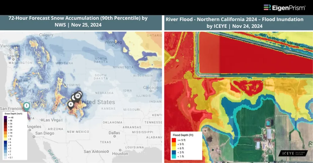
The National Weather Service in Sacramento, California, has issued a winter storm warning for the Sierra Nevada region from Saturday through Tuesday. Santa Rosa, California, recorded nearly 12.5 inches of rain in three days. Heavy snow is expected at higher elevations, with wind gusts potentially reaching up to 55 mph (88 kph). Total snowfall of about 4 feet (1.2 meters) is forecast, with the heaviest accumulation anticipated on Monday and Tuesday.
A mix of rain and snow is expected on Monday in the Midwest and Great Lakes regions. The East Coast is forecast to experience the most significant impacts on Thanksgiving Day and Black Friday. A low-pressure system is likely to bring rain to the Southeast early Thursday before tracking toward the Northeast. Cities like Boston and New York could face rain and breezy conditions, while parts of northern New Hampshire, northern Maine, and the Adirondacks might see snowfall.
In northeastern Pennsylvania, including the Pocono Mountains, heavy snow has already fallen. Some higher elevations have reported up to 17 inches (43 cm) of snow, with lighter accumulations in valley cities such as Scranton and Wilkes-Barre. The Catskills region of New York remains affected by power outages, with nearly 10,000 people still without electricity as of Sunday morning, two days after a storm dumped heavy snow across the area.
Upcoming Winter Storm Targets the US with Heavy Snow, Rain, and Strong Winds: Actionable Analytics on EigenPrism
Post-Event
All EigenPrism® users can assess the post-event impact of the snow accumulation and wind using the following event footprints:
72-hour observed snow accumulation as of Nov 25, 2024 by NOHRSC
Daily Peak Wind Gust across North America as of Nov 24, 2024, by Adiabat
ICEYE
Subscribers of ICEYE can use this footprint on EigenPrism® to quickly assess the impact of flood inundation:
River Flood – Northern California Southern Oregon (USA) 2024 – Flood Inundation by ICEYE as of Nov 24, 2024
Canopy Weather
Subscribers of Canopy Weather can assess the impact of Winds from Nov 24, 2024 using this footprint within EigenPrism®:
Daily CONUS Peak Wind Gusts- Prelim 3 as of Nov 24, 2024
Forecast
All EigenPrism® users can assess the forecasts associated with this event using the following report templates:
US Winter Storm Forecast Template
The report template auto-updates with the latest available forecasts, which include:
- 72-hr Forecast Freezing Rain Accumulation
- 72-hr Forecast Snow Accumulation
- Potential Winter Storm Overall Impact
US Flood Forecast Report Template
The report template auto-updates with the latest available footprints, which include:
- WPC 3-Day Excessive Rainfall Outlook from NWS
- US Flood Outlook from NWS
- NA 3-day Flood Potential from Adiabat
- NA 5-day Flood Potential from Adiabat
Winter Severity Component Report Template
This report template consists of the summary level (Potential Overall Winter Storm Impact) and all six component WSSI datasets from NWS:
- Potential Snow Amount Impact
- Potential Snow Load Impact
- Potential Ground Blizzard Impact
- Potential Ice Accumulation Impact
- Potential Blowing Snow Impact
- Potential Winter Storm Flash Freeze Impact
The report template auto-updates with the latest available datasets.
Escape the News Cycle | Get Alerts Automatically for Events Impacting Your Assets
With EigenPrism Alerts, you can free yourself from constant event monitoring. Set up personalized alerts based on predefined impact thresholds and choose how you receive them – via email, SMS, or directly within EigenPrism. This way, you can stay informed on your own terms, focusing only on the events that truly matter to your assets.
Set your alerts now.
Don’t have access to EigenPrism®?
Sign up for a trial account and access full impact reports of all events. Contact us, and we’ll set up a trial account for you