Bomb Cyclone Batters the West Coast, Bringing Strong Winds, Torrential Rain, and Blizzard Conditions
A powerful bomb cyclone that developed off the coast had intensified and swept strong winds across the Cascades and eastern Washington on Tuesday night into Wednesday, causing widespread destruction. The storm knocked out the power of many residents, sent at least five people to the hospital in Seattle, and tragically claimed the lives of two women—one in Bellevue and another in Lynnwood.
The bomb cyclone devastated British Columbia, Canada, with Vancouver Island bearing the brunt of its impact. The storm brought wind gusts up to 170 km/h, leading to widespread damage and significant power outages. Approximately 90,000 customers, primarily on Vancouver Island, were left without electricity as the storm downed trees and power lines. The severe weather also disrupted transportation, with several highways closed due to debris and hazardous conditions.
Eastern Washington was blanketed in snow, freezing rain, and blizzard conditions, prompting warnings for residents to travel cautiously on Wednesday. Utility crews working to restore power have faced significant challenges accessing heavily affected areas due to blocked roads and mudslides.
The storm is delivering severe wind and rain across the West Coast. So far, 2 to 4 inches of rain have been recorded in parts of western Washington, western Oregon, and northwestern California. The rainfall began in northwestern California on Tuesday afternoon and is expected to persist through Friday morning, with total rainfall amounts ranging from 12 to 18 inches by the end of the week.
Hurricane-force wind gusts, reaching up to 77 mph, have caused significant damage in western Washington, toppling trees and power lines. The Seattle area has been one of the hardest-hit regions.
In Northern California’s mountain areas, blizzard conditions are likely, with wind gusts between 50 and 70 mph. Snowfall of 1 to 4 feet is possible at higher elevations, with one foot already recorded in the mountains west of Redding, California.
According to the Weather Prediction Center, there is a level 3 of 4 risk for flooding rainfall in parts of Northern California on Wednesday. Risk level becomes level 4 of 4 for Thursday.
Bomb Cyclone Intensifies and Causes Havoc to the West Coast: Actionable Analytics on EigenPrism
Post-Event
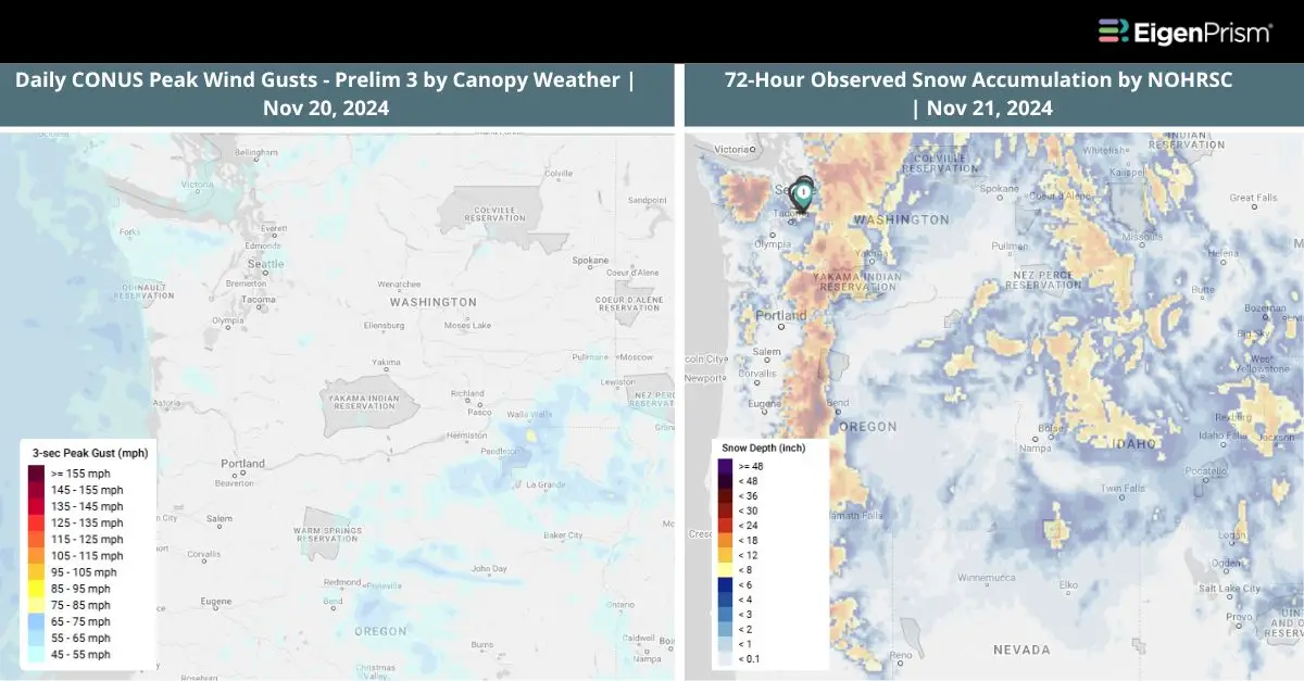
All EigenPrism® users can assess the post-event impact of the snow accumulation and wind using the following event footprints:
72-hour observed snow accumulation as of Nov 21, 2024 by NOHRSC
Daily Peak Wind Gust across North America as of Nov 20, 2024, by Adiabat
Canopy Weather
Subscribers of Canopy Weather can assess the impact of Winds from Nov 20, 2024 using this footprint within EigenPrism®:
Daily CONUS Peak Wind Gusts- Prelim 3 as of Nov 20, 2024
Forecast
All EigenPrism® users can assess the forecast of this event using the following report template:
US Bomb Cyclone Forecast 2024 Report Template
The report template auto-updates with the latest available forecasts, which include:
- 72-hr Forecast Snow Accumulation by NWS
- 72-hr Forecast Freezing Rain Accumulation by NWS
- Potential Winter Storm Overall Impact by NWS
All EigenPrism® users can assess the forecast of the flooding using the following report template.
US Flood Forecast Report Template
The report template auto-updates with the latest available footprints, which include:
- WPC 3-Day Excessive Rainfall Outlook from NWS
- US Flood Outlook from NWS
- NA 3-day Flood Potential from Adiabat
- NA 5-day Flood Potential from Adiabat
Winter Severity Component Report Template
This report template consists of the summary level (Potential Overall Winter Storm Impact) and all six component WSSI datasets from NWS:
- Potential Snow Amount Impact
- Potential Snow Load Impact
- Potential Ground Blizzard Impact
- Potential Ice Accumulation Impact
- Potential Blowing Snow Impact
- Potential Winter Storm Flash Freeze Impact
The report template auto-updates with the latest available datasets.
Nov 20 | West Coast Braces for Severe Weather as ‘Bomb Cyclone’ Ushers in Atmospheric River
A powerful low-pressure system known as a ‘bomb cyclone’ has intensified off the West Coast, ushering in a strong, long-lasting atmospheric river to the region. This system is expected to produce flooding rains, several feet of snow, and high winds through the end of the week.
By late Tuesday, the storm’s effects were felt in British Columbia, Canada, and Washington state, with authorities and PowerOutage.us reporting power outages affecting approximately 650,000 customers in the early hours of Wednesday in Washington.
Heavy rainfall is likely to cause flooding in areas with poor drainage and may lead to rising creeks and rivers. The heaviest rainfall totals through the end of the workweek are anticipated in Northern California (north of the Bay Area) extending into southwest Oregon. Some areas in this region could receive 8 to 12 inches of rain, with localized amounts up to 15 inches. Flood watches have been issued for the northern and central Sacramento Valley, Shasta County, and western Colusa County from Tuesday morning through Saturday.
Forecasters have warned that a whiteout blizzard could hit parts of the Cascade Mountains, which run along the spine of the West Coast. The storm could dump up to 2 feet of snow in Mount Shasta City in Northern California. Snow levels are expected to start low but will rise throughout the week, impacting travel in some mountain passes. The National Weather Service has issued various winter weather alerts from the Cascades to California’s northern Sierra.
Coastal regions of Northern California, Oregon, and Washington might sometimes experience wind gusts exceeding 60 or 70 mph. Stronger gusts are also expected in inland areas through the Cascades and their foothills. Meanwhile, wind speeds could reach up to 90 mph on the summit of Mount Rainier, which stands at an elevation of 14,411 feet in Washington state.
Bomb Cyclone Intensifies Off West Coast, Bringing Floods, Snow, and High Winds: Actionable Analytics on EigenPrism
Post Event
All EigenPrism® users can assess the post-event impact of the snow accumulation and wind using the following event footprints:
72-Hour Observed Snow Accumulation by NOhRSC as of Nov 20, 2024
Daily Peak Wind Gust across North America as of Nov 20, 2024, by Adiabat
Canopy Weather
Subscribers of Canopy Weather can assess the impact of Winds from Nov 20, 2024 using this footprint within EigenPrism®:
Daily CONUS Peak Wind Gusts- Prelim 1 as of Nov 20, 2024
Forecast
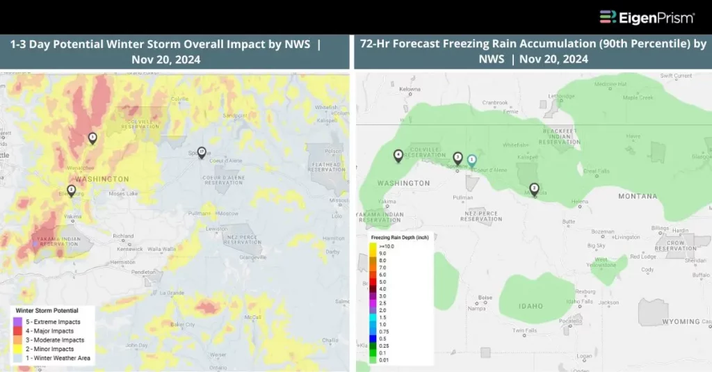
All EigenPrism® users can assess the forecast of this event using the following event footprints:
72-hr Forecast Snow Accumulation (90 Percentile) as of Nov 20, 2024, by NWS
72-Hr Forecast Freezing Rain Accumulation (90th Percentile) as of Nov 20, 2024, by NWS
All EigenPrism® users can assess the forecast of the flooding using the following report template.
US Flood Forecast Report Template
The report template auto-updates with the latest available footprints, which include:
- WPC 3-Day Excessive Rainfall Outlook from NWS
- US Flood Outlook from NWS
- NA 3-day Flood Potential from Adiabat
- NA 5-day Flood Potential from Adiabat
Winter Severity Component Report Template
This report template consists of the summary level (Potential Overall Winter Storm Impact) and all six component WSSI datasets from NWS:
- Potential Snow Amount Impact
- Potential Snow Load Impact
- Potential Ground Blizzard Impact
- Potential Ice Accumulation Impact
- Potential Blowing Snow Impact
- Potential Winter Storm Flash Freeze Impact
The report template auto-updates with the latest available datasets.
Escape the News Cycle | Get Alerts Automatically for Events Impacting Your Assets
With EigenPrism Alerts, you can free yourself from constant event monitoring. Set up personalized alerts based on predefined impact thresholds and choose how you receive them – via email, SMS, or directly within EigenPrism. This way, you can stay informed on your own terms, focusing only on the events that truly matter to your assets.
Set your alerts now.
Don’t have access to EigenPrism®?
Sign up for a trial account and access full impact reports of all events. Contact us, and we’ll set up a trial account for you.