Winter Storm Izzy Begins to Spread Heavy Snowfall and Freezing Rain into US Southeast
Jan 16, 2022:
The winter storm Izzy has started spreading freezing rain, ice and snow on US Southeast cities and states. Central Piedmont region of North Carolina saw freezing rain on Sunday morning. In addition to that, Southeastern Virginia is experiencing snowfall and is forecast to change to freezing rain.
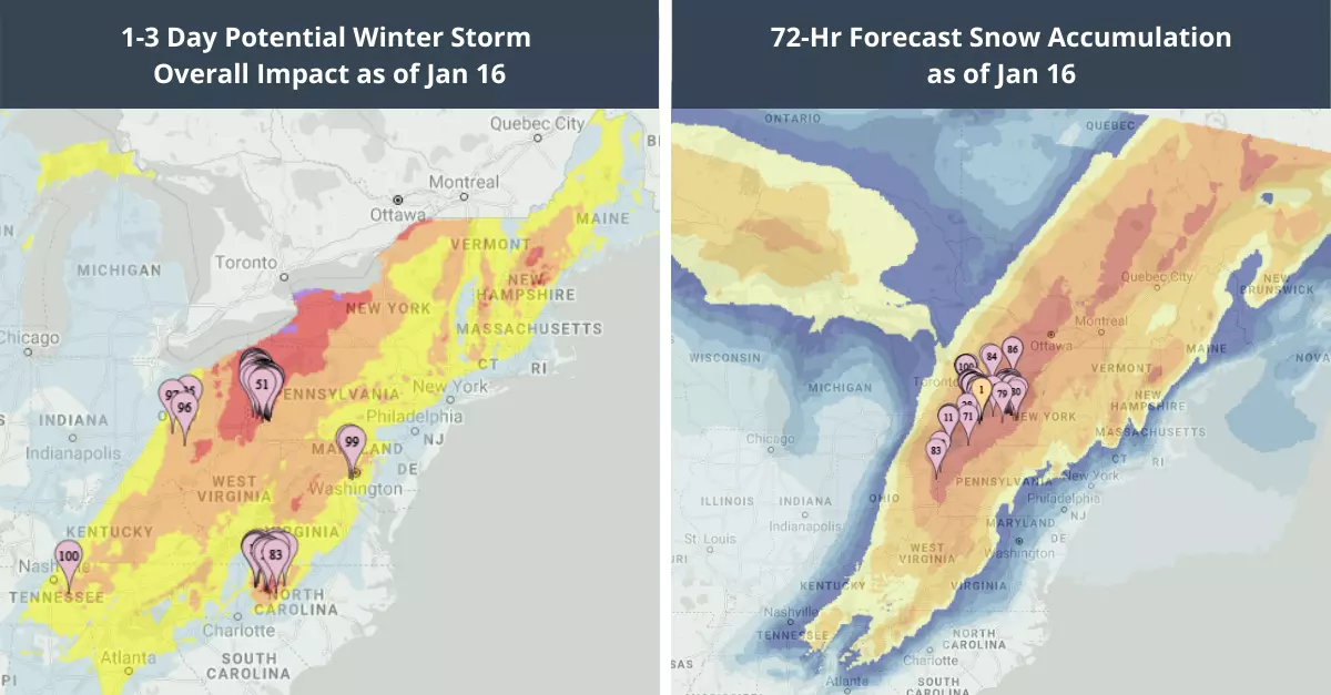
Winter weather alerts have been issued for Eastern US from Mississippi to Maine. The National Weather Service(NWS) has issued ice storm warning for portions of South Carolina, in effect through early Monday, with temperatures likely to remain sub-freezing until the start of next week. The ice accumulations will become very dangerous along and East of I-85 including Spartanburg, South Carolina, all the way up to Salisbury, North Carolina. This includes the entire metro Charlotte area. The highest snowfall totals are expected along the spine of the Appalachians as well as across the lower Great Lakes.
Assessing the impact
EigenPrism users can monitor the changing conditions with real-time access to the key perils associated with winter storm Izzy:
- 1-3 Day Potential Winter Storm Overall Impact – as of 2022-01-16
- 72-Hr Forecast Snow Accumulation – as of 2022-01-16
- 72-hour Observed Snow Accumulation – as of 2022-01-16
- 72-Hr Forecast Freezing Rain Accumulation – as of 2022-01-16
Jan 14, 2022:
According to the news by The Weather Channel, a major winter storm currently tracking into the upper Midwest, will spread massive snow, ice and wind across parts of the South and East through this weekend. The sprawling Winter Storm Izzy, will impact regions across North Dakota down to northern Georgia and Maine. The storm is likely to track from the Northern Plains towards New England into Monday.
The NWS has issued winter storm warnings, watches and advisories for parts of Midwest, South, Appalachians and interior Northeast. Moving forward, additional watches and warnings will likely be issued as the storms tracks its path. This could lead to dangerous weather conditions in those areas.
Potential Impact
In the Midwest, the heaviest snow up to 6 inches is likely in a band from North Dakota, South Dakota across Minnesota, Iowa and Missouri. Areas in Kansas City, Twin City may see lighter amounts of snow from Friday night.
In the US South, locally heavy snow is possible in Arkansas, Tennessee and parts of Kentucky. The snow accumulation will not only impact the roads, trees but also can cause power outages in these regions.
In US Northeast, heavy snow is likely in areas near the Boston-Washington Interstate 95 corridor – in parts of Virginia to Maine. Subsequently, coastal flooding is also likely in Jersey shore to southeast New England, and could extend to eastern Virginia and North Carolina.
Winter Storm Izzy: Snow Forecast
As per the NWS forecast, heavy snow will continue to spread southeastwards. It will taper off in North Dakota, South Dakota and parts of Minnesota on Friday. However, freezing rain is likely in southern Missouri, southeast Kansas and northeast Oklahoma.
From Saturday into Sunday, a mix of snow, freezing rain and sleet is forecasted from regions in Georgia, Carolina, Virginia to parts of Kentucky, Tennessee and northern Alabama. Additionally, strong winds are likely over parts of the Southeast, spreading into the mid-Atlantic and Northeast as low pressure strengthens with the storm.
The storm should exit into Atlantic Canada by Monday night, though gusty winds may linger in much of the Northeast.
Assessing the impact
EigenPrism users can monitor the changing conditions with real-time access to the key perils associated with winter storm Izzy:
- 1-3 Day Potential Winter Storm Overall Impact – as of 2022-01-14
- 72-Hr Forecast Snow Accumulation – as of 2022-01-14
- 72-Hr Forecast Freezing Rain Accumulation – as of 2022-01-14
Don’t have access to EigenPrism?
Sign-up for a trial account and access full impact reports of all events. Contact us and we’ll set up a trial account for you.