Typhoon Wipha Slams Southern China, Heads Toward Vietnam with Flood Threats
Storms continued to batter southern mainland China on Monday, triggering flash flood and landslide warnings, as Typhoon Wipha moved west after slamming into Hong Kong over the weekend. Torrential rains lashed Guangdong province, especially cities like Yangjiang, Zhanjiang, and Maoming, following the typhoon’s landfall near Taishan on Sunday evening.
In Hong Kong, the government raised its highest tropical cyclone warning as Wipha unleashed powerful winds and relentless rain. Streets were strewn with fallen trees, and several scaffolding structures collapsed amid the gale-force winds.
Before reaching China, Wipha had already wreaked havoc in the Philippines. Though it didn’t make direct landfall, the storm’s outer bands intensified monsoon rains, leading to widespread flooding and landslides. Now downgraded to a tropical storm, Wipha continues its westward path, entering the Gulf of Tonkin. It is expected to regain some strength before making landfall in northern Vietnam by Tuesday morning.
Actionable Analytics on EigenPrism
Forecast
Windstorm and Flood Dataset
All EigenPrism® users can assess the forecast of the tropical cyclone using the following report template:
Tropical Cyclone Wipha, July 2025, Forecast Impact Report Template
This report template consists of the following wind and flood footprints:
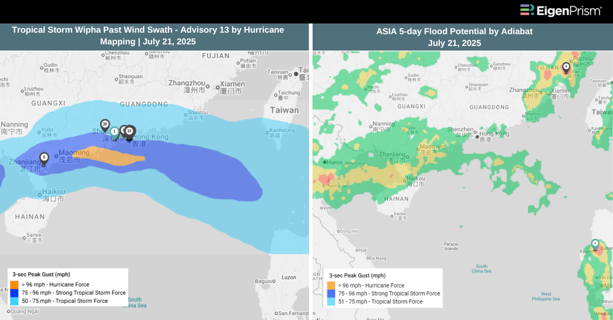
- Tropical Storm Wipha Forecast Wind Swath – Advisory 13 by Hurricane Mapping
- Tropical Storm Wipha 2025 5-day Forecast Max Winds by Adiabat
- Tropical-Storm-Force (>34 kt) Wind Probabilities by Hurricane Mapping
- Hurricane-Force (>64 kt) Wind Probabilities by Hurricane Mapping
- Asia 5-Day Flood Potential by Adiabat
The pages auto-update with the latest available data
Post-Event
Windstorm Dataset
All EigenPrism® users can assess the impact of the tropical cyclone using the following report template:
Tropical Cyclone Wipha, July 2025, Post-Event Impact Report
This report template enables you to assess the impact of the tropical cyclone based on the wind footprints:
- Tropical Storm Wipha 2025 Past Max Winds by Adiabat
- Tropical Storm Wipha Past Wind Swath – Advisory 13 by Hurricane Mapping
The pages auto-update with the latest available data.
Alerts
Users who have alerts set on their exposures for the relevant event sets, like those from Adiabat & Hurricane Mapping will receive alerts (if the event footprints impact these exposures).
To learn more about how to set an alert on a specific event set, check out this help center article.
Feel free to contact us at Prism.Support@eigenrisk.com or reach out directly to your Customer Success Manager with any questions or concerns. Our team is here to assist you with setting alerts, understanding report templates, and maximizing the actionable insights available through EigenPrism®.
Download the EigenAlert Mobile App Today!
With the EigenAlert mobile app, monitor alerts and impacted assets without being tied to your desk.

How to Get Started:
- Scan the QR code using your phone to download the app.
- Log in with your existing EigenPrism credentials.
- Begin accessing your alerts instantly.