Typhoon Fung-Wong Moves Towards Taiwan After Battering Philippines
Typhoon Fung-Wong, known locally as “Uwan,” has moved away from the Philippines and is now approaching southern Taiwan as a weakened tropical storm. The powerful cyclone made landfall in northern Luzon late Sunday with winds exceeding 185 km/h (115 mph), unleashing torrential rain, landslides, and widespread flooding. At least 1.4 million residents were forced to evacuate across multiple provinces.
Major infrastructure damage was reported, including collapsed bridges, power outages, and flooded towns after several dams overflowed. Authorities in Taiwan have already evacuated over 3,000 residents in coastal areas as a precaution.
Although Fung-Wong has weakened, meteorologists warn of continued heavy rainfall and flash flooding in affected regions. The storm’s remnants are expected to pass near Taiwan’s southern coast before heading toward the East China Sea.
Actionable Analytics on EigenPrism
Forecast
Windstorm & Flood Dataset
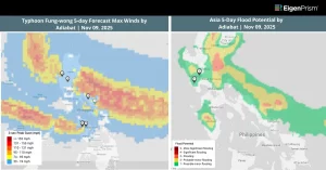
All EigenPrism® users can assess the forecast of the typhoon using the following report template:
This report template consists of the following wind and flood footprints: Wind Arrival Times from NOAA, Tropical Cyclone Forecast Maximum Winds, 5-Day and 3-Day Flood Potential from Adiabat, and Wind Swath from Hurricane Mapping. The pages auto-update with the latest available data.
Post Event
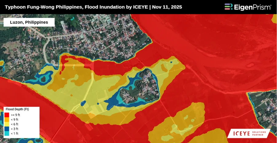
ICEYE
Subscribers of ICEYE in EigenPrism can assess the impact of flood inundation, using the following event footprint:
Windstorm Dataset
All EigenPrism® users can assess the impact of the typhoon using the following report template:
The report template consists of the following wind footprints: Past max winds by Adiabat and Past wind swath by Hurricane Mapping. The pages auto-update with the latest available data.
Alerts
Users who have alerts set on their exposures for the relevant event sets, like those from NOAA, Adiabat & Hurricane Mapping, will receive alerts (if the event footprints impact these exposures). To learn more about how to set an alert on a specific event set, check out this help center article. Feel free to contact us at Prism.Support@eigenrisk.com or reach out directly to your Customer Success Manager with any questions or concerns. Our team is here to assist you with setting alerts, understanding report templates, and maximizing the actionable insights available through EigenPrism®.
_________________________________________________________________________________
Nov 10 | Typhoon Fung-Wong Tracks Away From Philippines Following Destructive Landfall
Typhoon Fung-wong has exited the northwestern Philippines after unleashing severe flooding and landslides, triggering massive power outages, and forcing the evacuation of more than 1.4 million residents.
Typhoon made its first landfall late Sunday in Dinalungan, Aurora province, as a powerful Category 4 system. Upon landfall, Fung-wong packed sustained winds of roughly 130 mph (215 km/h) and even stronger gusts, triggering dangerous storm surge, relentless rainfall, and widespread wind damage across northern Luzon.
By early Monday, the system had weakened slightly to typhoon strength as it tracked across Luzon. According to PAGASA, sustained winds eased from 185 km/h to 165 km/h, though gusts remained extremely intense, still peaking above 275 km/h.
Fung-wong is forecast to continue weakening as it moves away from the Philippines and heads farther north toward Taiwan. Still, forecasters caution that heavy rain bands and hazardous seas may persist in coastal areas.
Actionable Analytics on EigenPrism
Forecast
Windstorm & Flood Dataset
All EigenPrism® users can assess the forecast of the typhoon using the following report template:
This report template consists of the following wind and flood footprints: Wind Arrival Times from NOAA, Tropical Cyclone Forecast Maximum Winds, 5-Day and 3-Day Flood Potential from Adiabat, and Wind Swath from Hurricane Mapping. The pages auto-update with the latest available data.
Post Event
Windstorm Dataset
All EigenPrism® users can assess the impact of the typhoon using the following report template:
The report template consists of the following wind footprints: Past max winds by Adiabat and Past wind swath by Hurricane Mapping. The pages auto-update with the latest available data.
Alerts
Users who have alerts set on their exposures for the relevant event sets, like those from NOAA, Adiabat & Hurricane Mapping, will receive alerts (if the event footprints impact these exposures). To learn more about how to set an alert on a specific event set, check out this help center article. Feel free to contact us at Prism.Support@eigenrisk.com or reach out directly to your Customer Success Manager with any questions or concerns. Our team is here to assist you with setting alerts, understanding report templates, and maximizing the actionable insights available through EigenPrism®.
Download the EigenAlert Mobile App Today!
With the EigenAlert mobile app, monitor alerts and impacted assets without being tied to your desk.

How to Get Started:
- Scan the QR code using your phone to download the app.
- Log in with your existing EigenPrism credentials.
- Begin accessing your alerts instantly.