Hurricane Erin Weakens to Cat 2 but Poses Serious Surf and Flood Threats to the Carolinas
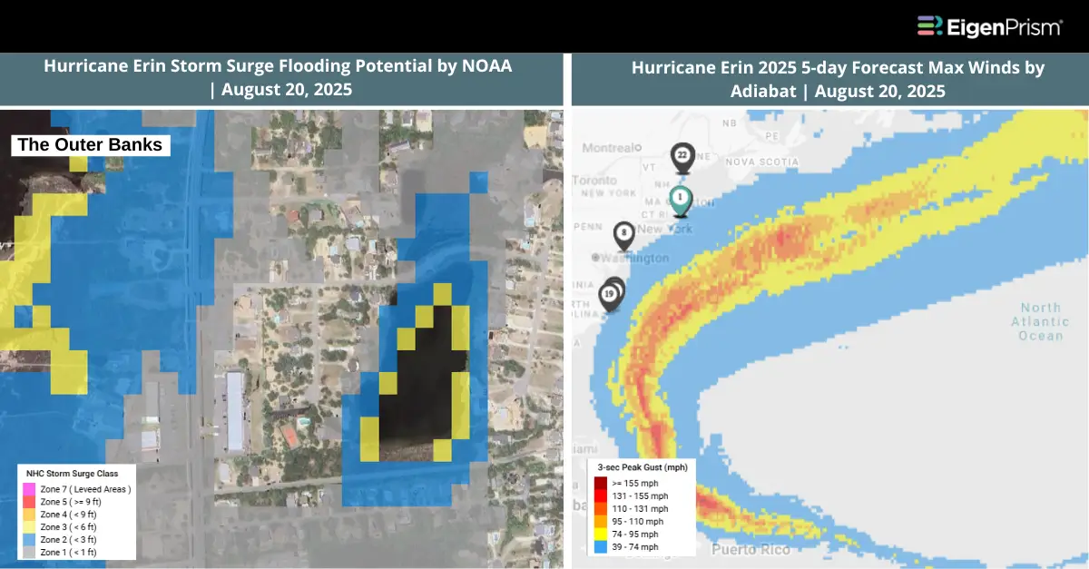
Hurricane Erin has weakened to a Category 2 storm but continues to pose significant threats along the US East Coast. The storm is now carrying maximum sustained winds of about 105 mph (168 km/h), according to the National Hurricane Center (NHC). A state of emergency has been declared in North Carolina as authorities prepare for dangerous surf, rip currents, and potential coastal flooding.
According to the NHC’s latest advisory 35, Erin is expected to move between Bermuda and the US East Coast on Wednesday and Thursday. While the storm is not expected to make landfall on the East Coast, it has triggered a tropical storm warning for North Carolina’s Outer Banks.
The Outer Banks are forecast to experience strong winds above 40 mph, torrential rain, and a storm surge of 2 to 4 feet through the week. A high surf advisory has also been issued, with destructive waves reaching up to 20 feet. By Thursday, large waves and dangerous rip currents are expected to impact beaches along the Northeast, including the Jersey Shore and Long Island. Vulnerable coastlines from New Jersey to Rhode Island could face destructive surf and significant erosion.
Actionable Analytics on EigenPrism
Forecast
Windstorm Datasets
All EigenPrism® users can assess the forecast of the tropical cyclone using the following report template.
Hurricane Erin, Aug 2025, Forecast Impact Report Template
The report template auto-updates with the latest available footprints, which include:
- Tropical-Storm-Force (greater than 34 kt) Wind Arrival Times by NOAA
- Tropical Storm Erin Forecast Wind Swath by Hurricane Mapping
- Tropical Storm Erin 2025 5-day Forecast Max Winds by Adiabat
- 5-day Tropical-Storm-Force (greater than 34 kt) Wind Probabilities by Hurricane Mapping
- WPC 3-Day Excessive Rainfall Outlook by NWS
- North America 5-day Flood Potential by Adiabat
The pages auto-update with the latest available data.
NHC Tropical Cyclone WMS Layers
EigenPrism users can also view the latest official NHC forecast track alongside event footprints using the Tropical Cyclones WMS layer.
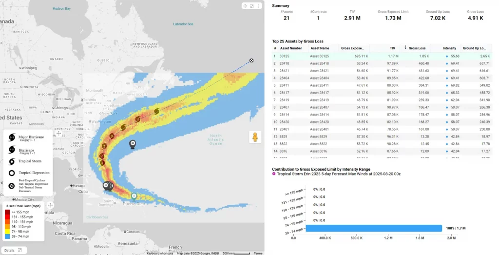
Here’s how you can access the WMS layers:
- On the analysis or report page, click the overlays button in the top right section of the map.
- Click “+Add an Overlay” and choose “Add a WMS layer”
- Search for NHC Tropical Cyclones and then click on Tropical Cyclone Forecast Track
Post-Event
Windstorm Dataset
All EigenPrism® users can assess the impact of the hurricane using the following report template:
Hurricane Erin, Aug 2025, Post-Event Impact Report Template
This report template enables you to assess the impact of the tropical cyclone based on the wind footprints:
- Tropical Storm Erin 2025 Past Max Winds by Adiabat
- Hurricane Erin Past Wind Swath by Hurricane Mapping
Alerts
Users who have alerts set on their exposures for the relevant event sets, like those from NOAA, Adiabat & Hurricane Mapping, will receive alerts (if the event footprints impact these exposures).
To learn more about how to set an alert on a specific event set, check out this help center article.
Feel free to contact us at Prism.Support@eigenrisk.com or reach out directly to your Customer Success Manager with any questions or concerns. Our team is here to assist you with setting alerts, understanding report templates, and maximizing the actionable insights available through EigenPrism®.
Aug 18 | Hurricane Erin Intensifies to Cat 4 Again, Threatening the Bahamas & the East Coast with Heavy Rainfall
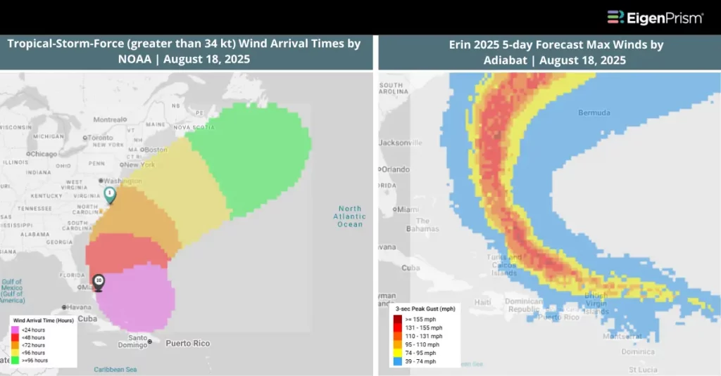
Hurricane Erin has undergone rapid transformation over the past few days. It strengthened from a Category 1 hurricane with 75 mph winds on Friday, then to a Category 5 on Saturday with winds near 155–160 mph. By Sunday, Erin weakened to Category 3 with winds around 125 mph. After completing an eyewall replacement cycle, Hurricane Erin has now restrengthened to a Category 4 hurricane as it moves near the southeast Bahamas and Turks & Caicos.
Erin is expected to remain powerful for the next several days. Erin’s path continued to curve northward, with the center of the hurricane passing just to the north of the northern Leeward Islands and Puerto Rico. Tropical storm warnings remain in place for the Turks and Caicos Islands and the southeast Bahamas, where Erin’s outer bands are expected to bring heavy rain and gusty winds.
Between Florida’s Space Coast and coastal New England, large waves and hazardous conditions are anticipated. Forecasters warn that wave heights could reach 8–12 feet along the Carolina coastline by Thursday, with the potential for very large swells spreading northward into the Mid-Atlantic and Northeast.
Actionable Analytics on EigenPrism
Forecast
Windstorm Datasets
All EigenPrism® users can assess the forecast of the tropical cyclone using the following report template.
Hurricane Erin, Aug 2025, Forecast Impact Report Template
The report template auto-updates with the latest available footprints, which include:
- Tropical-Storm-Force (greater than 34 kt) Wind Arrival Times by NOAA
- Tropical Storm Erin Forecast Wind Swath by Hurricane Mapping
- Tropical Storm Erin 2025 5-day Forecast Max Winds by Adiabat
- 5-day Tropical-Storm-Force (greater than 34 kt) Wind Probabilities by Hurricane Mapping
- WPC 3-Day Excessive Rainfall Outlook by NWS
- North America 5-day Flood Potential by Adiabat
The pages auto-update with the latest available data.
Post-Event
Windstorm Dataset
All EigenPrism® users can assess the impact of the hurricane using the following report template:
Hurricane Erin, Aug 2025, Post-Event Impact Report Template
This report template enables you to assess the impact of the tropical cyclone based on the wind footprints:
- Tropical Storm Erin 2025 Past Max Winds by Adiabat
- Hurricane Erin Past Wind Swath by Hurricane Mapping
Alerts
Users who have alerts set on their exposures for the relevant event sets, like those from NOAA, Adiabat & Hurricane Mapping, will receive alerts (if the event footprints impact these exposures).
To learn more about how to set an alert on a specific event set, check out this help center article.
Feel free to contact us at Prism.Support@eigenrisk.com or reach out directly to your Customer Success Manager with any questions or concerns. Our team is here to assist you with setting alerts, understanding report templates, and maximizing the actionable insights available through EigenPrism®.
Aug 15, 2025 | Hurricane Erin Becomes First Hurricane of 2025 Atlantic Season
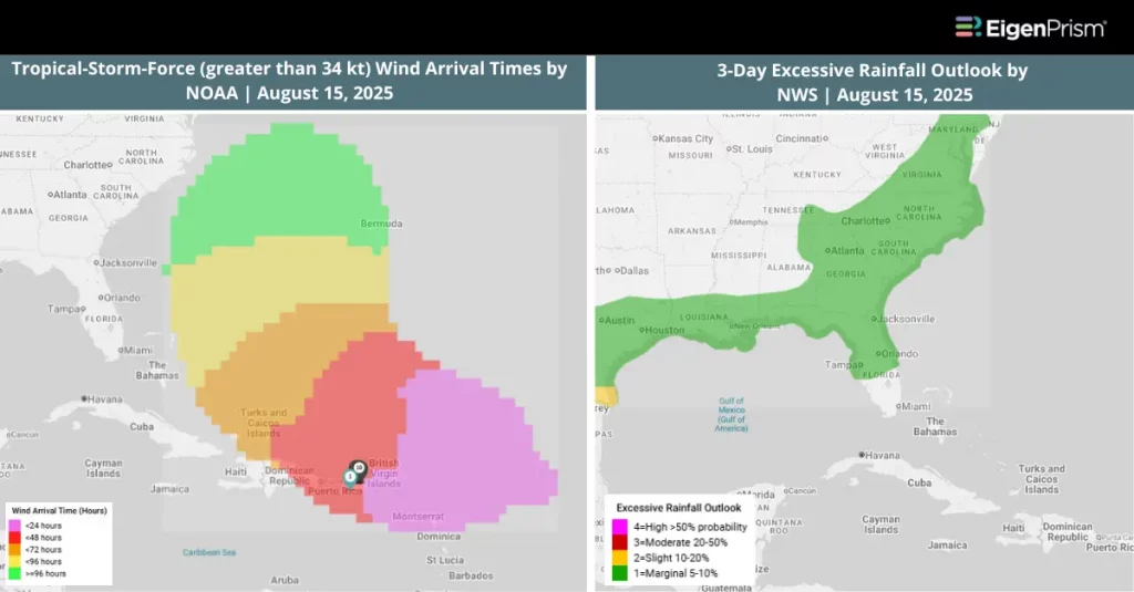
Tropical Storm Erin strengthened into the first Atlantic hurricane of the 2025 season on Friday morning after strengthening from a tropical storm, according to the National Hurricane Center (NHC). Packing maximum sustained winds of 75 mph, Erin is moving west-northwest at 18 mph and is expected to pass near or just north of the northern Leeward Islands over the weekend.
Forecasters warn that the storm will bring heavy rainfall from late Friday through the weekend to the northernmost Leeward Islands, the US and British Virgin Islands, and southern and eastern Puerto Rico. The system will also generate dangerous swells across these regions, increasing the risk of coastal flooding and hazardous rip currents.
The NHC says that Erin could intensify into a Category 4 hurricane by early next week as it tracks over warm waters. Erin is expected to pass between North Carolina and Bermuda in next week. A rising rip current can be seen in the week ahead from Florida to Massachusetts.
Actionable Analytics on EigenPrism
Forecast
Windstorm Datasets
All EigenPrism® users can assess the forecast of the tropical cyclone using the following report template.
Hurricane Erin, Aug 2025, Forecast Impact Report Template
The report template auto-updates with the latest available footprints, which include:
- Tropical-Storm-Force (greater than 34 kt) Wind Arrival Times by NOAA
- Tropical Storm Erin Forecast Wind Swath by Hurricane Mapping
- Tropical Storm Erin 2025 5-day Forecast Max Winds by Adiabat
- 5-day Tropical-Storm-Force (greater than 34 kt) Wind Probabilities by Hurricane Mapping
- WPC 3-Day Excessive Rainfall Outlook by NWS
- North America 5-day Flood Potential by Adiabat
The pages auto-update with the latest available data.
Alerts
Users who have alerts set on their exposures for the relevant event sets, like those from NOAA, Adiabat & Hurricane Mapping, will receive alerts (if the event footprints impact these exposures).
To learn more about how to set an alert on a specific event set, check out this help center article.
Feel free to contact us at Prism.Support@eigenrisk.com or reach out directly to your Customer Success Manager with any questions or concerns. Our team is here to assist you with setting alerts, understanding report templates, and maximizing the actionable insights available through EigenPrism®.
Aug 13, 2025 | Tropical Storm Erin Could Become the First Hurricane of the 2025 Atlantic Season
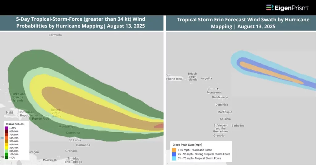
Tropical Storm Erin, which formed on Monday in the eastern tropical Atlantic, is expected to become the first hurricane of the 2025 Atlantic season later this week. The storm is expected to move toward warmer waters in the coming days, creating favorable conditions for it to strengthen into a hurricane by late week.
As of early Tuesday, Erin was positioned more than 1,500 miles east of the northern Leeward Islands. Forecast models suggest it could intensify to Category 3 strength by the weekend, tracking just north of the Caribbean islands.
According to the National Hurricane Center (NHC), Erin’s strength is likely to remain steady through Tuesday night, with gradual intensification expected from Wednesday onward. The storm may achieve hurricane status by late Thursday.
Impacts could begin affecting the northern Leeward Islands, including the Virgin Islands and Puerto Rico, by Friday night and into the weekend, bringing high surf, dangerous rip currents, heavy rainfall, and gusty winds. For now, the probability of a US East Coast landfall remains low.
Actionable Analytics on EigenPrism
Forecast
Windstorm Datasets
All EigenPrism® users can assess the forecast of the tropical cyclone using the following report template.
Tropical Storm Erin, Aug 2025, Forecast Impact Report Template
The report template auto-updates with the latest available footprints, which include:
- Tropical-Storm-Force (greater than 34 kt) Wind Arrival Times by NOAA
- Tropical Storm Erin Forecast Wind Swath by Hurricane Mapping
- Tropical Storm Erin 2025 5-day Forecast Max Winds by Adiabat
- 5-day Tropical-Storm-Force (greater than 34 kt) Wind Probabilities by Hurricane Mapping
- 5-day Hurricane-Force (greater than 64 kt) Wind Probabilities by Wind Hurricane Mapping
The pages auto-update with the latest available data.
Alerts
Users who have alerts set on their exposures for the relevant event sets, like those from NOAA, Adiabat & Hurricane Mapping, will receive alerts (if the event footprints impact these exposures).
To learn more about how to set an alert on a specific event set, check out this help center article.
Feel free to contact us at Prism.Support@eigenrisk.com or reach out directly to your Customer Success Manager with any questions or concerns. Our team is here to assist you with setting alerts, understanding report templates, and maximizing the actionable insights available through EigenPrism®.
Download the EigenAlert Mobile App Today!
With the EigenAlert mobile app, monitor alerts and impacted assets without being tied to your desk.

How to Get Started:
- Scan the QR code using your phone to download the app.
- Log in with your existing EigenPrism credentials.
- Begin accessing your alerts instantly.