The Season’s First Named Tropical Storm, Alberto, Caused Severe Flooding in Texas and Mexico
Tropical Storm Alberto, the first named storm of the 2024 Atlantic hurricane season, made landfall in northeastern Mexico on Thursday morning after unleashing heavy rainfall and coastal flooding in parts of Texas. Officials reported flooded roadways in the Houston metropolitan area, and the tide encroached on raised residences in coastal towns like Surfside Beach. Authorities in Mexico were closely monitoring water levels in dams, rivers, and streams, while also clearing drainage systems to prevent potential flooding.
The National Hurricane Center reported that Alberto had maximum sustained winds of 45 mph and was a large storm, with tropical-force winds extending up to 415 miles from its center. The primary concern was the predicted rainfall of over a foot in some areas of Texas and Mexico. Tropical storm warnings remained in effect for coastal regions on both sides of the border.
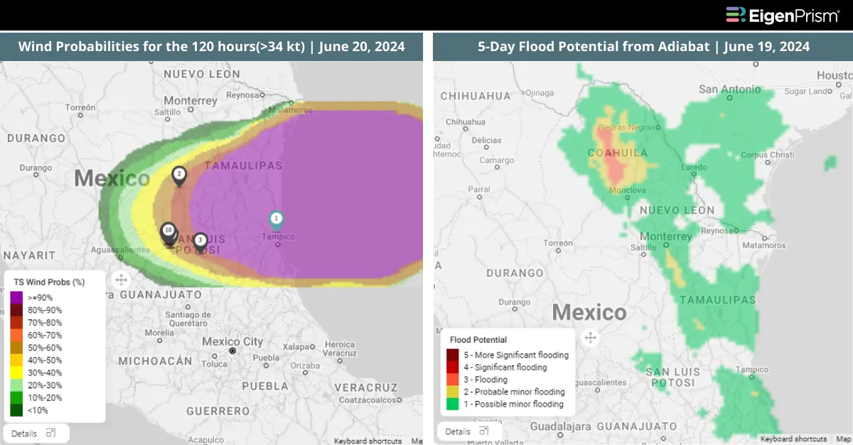
Tropical Storm Alberto Causes Flooding in Texas and Mexico : Actionable Insights on EigenPrism
Post Event
Subscribers of ICEYE can use these real-time footprints on EigenPrism®, to quickly assess the impact of flood
US Flood Inundation Footprints from ICEYE
Forecast
All EigenPrism® users can assess the forecast of the flooding due to this event using the following report template:
Tropical Cyclone Forecast Report
The report template auto-updates with the latest available footprints, which include:
- Forecast Wind Swath from Hurricane Mapping
- Tropical-Storm-Force (>34 kt) Wind Probabilities for the 120 hours from Hurricane Mapping
- WPC 3-Day Excessive Rainfall Outlook by NWS
- 5-day Flood Potential from Adiabat
- 3-day Flood Potential from Adiabat
- US Significant River Flood 5-day Outlook from NWS
___________________________________
Texas and Mexico on Alert for Potential Tropical Cyclone One
The 2024 Atlantic hurricane season is expected to be active, with tropical disturbances emerging in the Gulf of Mexico. The first system, Potential Tropical Cyclone One, is likely to form in the southwestern Gulf of Mexico and could bring torrential rainfall and severe flooding threats to regions of Mexico, Central America, and the United States. The National Hurricane Center has forecasted rainfall totals of 5 to 10 inches across northeast Mexico into South Texas, with maximum totals of up to 15 inches possible. This level of rainfall is likely to result in flash and urban flooding, as well as new and renewed river flooding. Texas is on alert with a tropical storm watch, as Tropical Storm One could bring significant rainfall and potential flooding. Heavy rain is already underway in parts of Mexico, Guatemala, Belize, El Salvador, and Honduras, with double-digit rainfall totals projected for these areas by Thursday.
The system is expected to move northwestward, potentially impacting the Mexican coast or southern Texas by Wednesday night or early Thursday. Another tropical threat is brewing in the Atlantic, which could approach the southeastern United States by Thursday or Friday. The NHC has issued warnings for heavy rainfall and flooding in various areas, including Texas and Florida.
Texas and Mexico on Alert for Potential Tropical Storm: Actionable Insights on EigenPrism
Forecast
All EigenPrism® users can assess the forecast of this event using the following report template:
Tropical Cyclone Forecast Report
The report template auto-updates with the latest available footprints, which include:
- Forecast Wind Swath from Hurricane Mapping
- Tropical-Storm-Force (>34 kt) Wind Probabilities for the 120 hours from Hurricane Mapping
- WPC 3-Day Excessive Rainfall Outlook by NWS
- 5-day Flood Potential from Adiabat
- 3-day Flood Potential from Adiabat
- US Significant River Flood 5-day Outlook from NWS
Escape the News Cycle | Get Alerts Automatically For Events Impacting Your Assets
With EigenPrism Alerts, you can set Alerts and free yourself from constant event monitoring. Set up personalized alerts based on predefined impact thresholds and choose how you receive them – via email, SMS, or directly within EigenPrism. This way, you stay informed on your own terms, focusing only on the events that truly matter to your assets.
Set your alerts now.
Don’t have access to EigenPrism®?
Sign up for a trial account and access full impact reports of all events. Contact us, and we’ll set up a trial account for you.