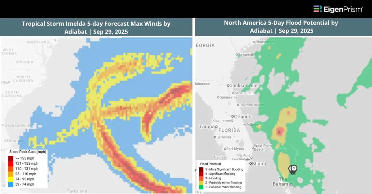
Tropical Storm Imelda Strengthens in the Atlantic, Poses Threat to Southeast US
Tropical Storm Imelda developed in the Atlantic Ocean on Sunday and could bring impacts to parts of the southeastern US in the coming days. According to the National Hurricane Center, the storm currently carries sustained winds of 40 mph and is positioned about 335 miles southeast of Cape Canaveral, Florida.
Tropical Storm Imelda has already delivered dangerous rainfall across parts of the Caribbean, causing flooding in the Dominican Republic and Puerto. A storm surge of 2ft is possible along the Carolinas’ coasts too, with closer to 3ft possible for the Bahamas.
Imelda is expected to continue moving northward across the Bahamas through Monday, where tropical storm conditions are already being felt. By Tuesday, the system is forecast to near the coasts of Georgia and South Carolina, likely intensifying into a strong tropical storm or possibly reaching Category 1 hurricane strength.
Forecasters warn that storm surge and coastal flooding may affect portions of the Carolinas and coastal Georgia early next week. Even if Imelda does not make landfall, the system is still likely to produce indirect effects along much of the East Coast, extending as far north as Virginia.
Actionable Analytics on EigenPrism
Windstorm & Flood Datasets
Forecast
All EigenPrism® users can assess the forecast of the tropical depression using the following report template:
This report template consists of the following wind and flood footprints: Wind arrival times & Storm Surge Flooding Potential by NOAA, Wind probabilities (34 & 64 kt) by Hurricane Mapping, WPC Excessive Rainfall Outlook by NWS and 5-day Flood Potential by Adiabat. The pages auto-update with the latest available data.
Reask
Subscribers of Reask can use these real-time footprints on EigenPrism® to quickly assess the wind impact:
- Potential Tropical Cyclone 90th percentile windspeed footprint from Reask LiveCyc as of Sep 27, 2025
- Potential Tropical Cyclone 50th percentile windspeed footprint from Reask LiveCyc as of Sep 27, 2025
Post-Event
All EigenPrism® users can assess the impact of the tropical cyclone using the following report template:
The report template consists of the following wind footprints: Past max winds by Adiabat and Past wind swath by Hurricane Mapping. The pages auto-update with the latest available data.
Alerts
Users who have alerts set on their exposures for the relevant event sets, like those from NOAA, Adiabat & Hurricane Mapping, will receive alerts (if the event footprints impact these exposures).
To learn more about how to set an alert on a specific event set, check out this help center article.
Feel free to contact us at Prism.Support@eigenrisk.com or reach out directly to your Customer Success Manager with any questions or concerns. Our team is here to assist you with setting alerts, understanding report templates, and maximizing the actionable insights available through EigenPrism®.
Not an EigenPrism User? Here’s a Quick Way to Check ZIP-Level Impact
For underwriters, brokers, and portfolio managers who need fast visibility into impacted ZIP codes, we’ve built a tool called ZIP Response on our website. It’s a free, no-login tool that highlights the top ZIP codes that are most impacted during active events, such as hurricanes, floods, wildfires, and severe storms.
You can request the complete ZIP list by simply filling out a short form and get it delivered straight to your inbox.
If you’d like to explore the impacted ZIP codes for this event, visit ZIP Response.
Or Contact us, to have more info on this.
Sep 27 | Tropical Depression Nine Forms Near the Bahamas, Expected to Strengthen Into a Hurricane
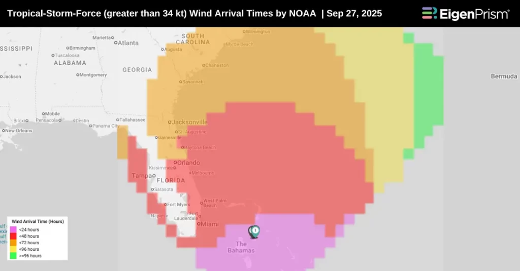
Potential Tropical Cyclone Nine has been upgraded to Tropical Depression Nine on Saturday morning between Cuba and the Bahamas with maximum sustained winds of 35 mph, according to the latest from the National Hurricane Center.
Strengthening is expected over the next few days, and the system is forecast to become a tropical storm tonight and a Category 1 hurricane by late Monday or Tuesday.
Tropical storm watches have been issued for the east coast of Florida from the Palm Beach and Martin County line northward to the Flagler and Volusia County line. It could also bring storm surges and high winds to the southeast US coastline early next week.
There is a significant threat of heavy rainfall early next week from coastal Georgia through the Carolinas and into the southern Mid-Atlantic states, which could cause flash, urban, and river flooding.
Heavy rainfall and gusty winds are expected to impact Cuba, Hispaniola, Jamaica, and the Bahamas throughout the weekend, potentially causing flooding and mudslides.
Actionable Analytics on EigenPrism
Windstorm & Flood Datasets
Forecast
All EigenPrism® users can assess the forecast of the tropical depression using the following report template:
This report template consists of the following wind and flood footprints: Wind arrival times & Storm Surge Flooding Potential by NOAA, Wind probabilities (34 & 64 kt) by Hurricane Mapping, WPC Excessive Rainfall Outlook by NWS and 5-day Flood Potential by Adiabat. The pages auto-update with the latest available data.
Reask
Subscribers of Reask can use these real-time footprints on EigenPrism® to quickly assess the wind impact:
- Potential Tropical Cyclone 90th percentile windspeed footprint from Reask LiveCyc as of Sep 27, 2025
- Potential Tropical Cyclone 50th percentile windspeed footprint from Reask LiveCyc as of Sep 27, 2025
Alerts
Users who have alerts set on their exposures for the relevant event sets, like those from NOAA, Adiabat & Hurricane Mapping, will receive alerts (if the event footprints impact these exposures).
To learn more about how to set an alert on a specific event set, check out this help center article.
Feel free to contact us at Prism.Support@eigenrisk.com or reach out directly to your Customer Success Manager with any questions or concerns. Our team is here to assist you with setting alerts, understanding report templates, and maximizing the actionable insights available through EigenPrism®.
Download the EigenAlert Mobile App Today!
With the EigenAlert mobile app, monitor alerts and impacted assets without being tied to your desk.

How to Get Started:
- Scan the QR code using your phone to download the app.
- Log in with your existing EigenPrism credentials.
- Begin accessing your alerts instantly.