Tropical Cyclone Fina Strengthens Near Northern Australia, Could Reach Category 3
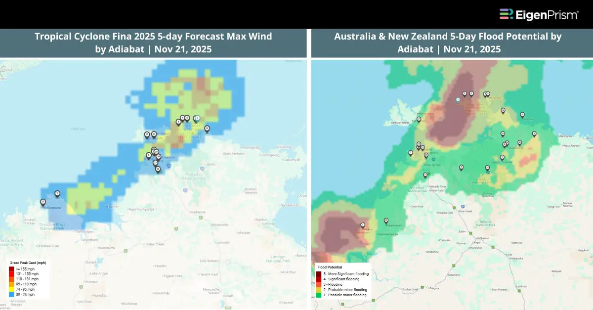
Tropical Cyclone Fina has strengthened into a Category 2 system and may intensify further into a Category 3 storm later today as it continues moving closer to the Northern Territory coastline. Currently, sustained winds are around 95 km/h near the core, with gusts reaching up to 130 km/h.
As of the latest update, the system remains over the Arafura Sea but is steadily shifting toward mainland Australia, with its center likely to approach the Cobourg Peninsula and surrounding communities by Saturday. The Bureau of Meteorology (BOM) warns that Fina will bring intense rainfall, flash flooding, and destructive wind gusts as it nears land. Several hundred millimetres of rain are possible across exposed regions this weekend, with conditions deteriorating rapidly as the cyclone edges closer.
Actionable Analytics on EigenPrism
Forecast
Windstorm & Flood Dataset
All EigenPrism® users can assess the forecast of the tropical storm using the following footprints:
This report template consists of the following wind and flood footprints: 5-day Forecast Max Winds by Adiabat, Wind Swath Advisory by Hurricane Mapping, 5-Day & 3-Day ANZ Flood Potential. The pages auto-update with the latest available data.
Post Event
All EigenPrism® users can assess the impact of the tropical cyclone using the following report template:
The report template consists of the following wind footprints: Past max winds by Adiabat and Past wind swath by Hurricane Mapping. The pages auto-update with the latest available data.
Alerts
Users who have alerts set on their exposures for the relevant event sets, like those from Adiabat & Hurricane Mapping, will receive alerts (if the event footprints impact these exposures). To learn more about how to set an alert on a specific event set, check out this help center article. Feel free to contact us at Prism.Support@eigenrisk.com or reach out directly to your Customer Success Manager with any questions or concerns. Our team is here to assist you with setting alerts, understanding report templates, and maximizing the actionable insights available through EigenPrism®.
Nov 20 | Tropical Cyclone Fina Brings Destructive Winds & Torrential Rains In Northern Australia
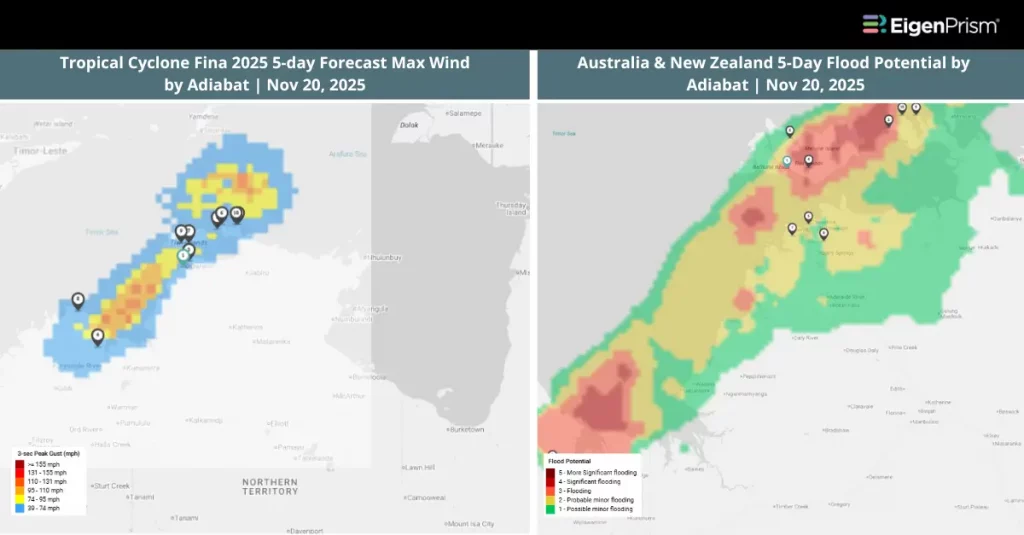
Tropical Cyclone Fina has intensified off the Northern Territory’s Top End and could reach the coastline by Friday or Saturday, bringing destructive winds and heavy rainfall to the region.
According to the Bureau of Meteorology (BOM), the system strengthened to a Category 2 cyclone overnight, after first being classified as Category 1 on Wednesday. It is currently 360km northeast of Darwin and 13km north northeast of Minjilang.
A cyclone watch has been issued for communities across north-west Arnhem Land and the Tiwi Islands, with the storm projected to make landfall as a Category 2 system. Meteorologists expect Fina to gradually shift southward and then southwest toward the coast later on Thursday.
At present, the cyclone is producing sustained winds of around 75 km/h near its center, with gusts reaching up to 100 km/h. BOM forecasters warn that conditions could deteriorate further, as the storm may intensify to Category 3 strength by Friday or Saturday as it nears land.
Actionable Analytics on EigenPrism
Forecast
Windstorm & Flood Dataset
All EigenPrism® users can assess the forecast of the tropical storm using the following footprints:
This report template consists of the following wind and flood footprints: 5-day Forecast Max Winds by Adiabat, Wind Swath Advisory by Hurricane Mapping, 5-Day & 3-Day ANZ Flood Potential. The pages auto-update with the latest available data.
Post Event
All EigenPrism® users can assess the impact of the tropical cyclone using the following report template:
The report template consists of the following wind footprints: Past max winds by Adiabat and Past wind swath by Hurricane Mapping. The pages auto-update with the latest available data.
Alerts
Users who have alerts set on their exposures for the relevant event sets, like those from Adiabat & Hurricane Mapping, will receive alerts (if the event footprints impact these exposures). To learn more about how to set an alert on a specific event set, check out this help center article. Feel free to contact us at Prism.Support@eigenrisk.com or reach out directly to your Customer Success Manager with any questions or concerns. Our team is here to assist you with setting alerts, understanding report templates, and maximizing the actionable insights available through EigenPrism®.
Not an EigenPrism User? Here’s a Quick Way to Check ZIP-Level Impact
For underwriters, brokers, and portfolio managers who need fast visibility into impacted ZIP codes, we’ve built a tool called ZIP Response on our website. It’s a free, no-login tool that highlights the top ZIP codes that are most impacted during active events, such as hurricanes, floods, wildfires, and severe storms.
You can request the complete ZIP list by simply filling out a short form and get it delivered straight to your inbox.
If you’d like to explore the impacted ZIP codes for this event, visit ZIP Response.
Or Contact us, to have more info on this.
Download the EigenAlert Mobile App Today!
With the EigenAlert mobile app, monitor alerts and impacted assets without being tied to your desk.

How to Get Started:
- Scan the QR code using your phone to download the app.
- Log in with your existing EigenPrism credentials.
- Begin accessing your alerts instantly.