Ex-Tropical Cyclone Alfred Drenches Queensland with Historic Rainfall, Triggers Widespread Flooding
Ex-Tropical Cyclone Alfred has brought the heaviest rainfall in decades to southeast Queensland. Although it weakened before making landfall on Saturday, it caused severe beach erosion and record-breaking waves. The Gold Coast recorded a 12.3-meter wave, the highest in 38 years. Beach erosion has been severe, with some dunes forming escarpments up to six meters high, even along major tourist beaches.
The most significant impact came from torrential rainfall, with widespread totals of 200-400mm reported across Brisbane, the Gold Coast, the Scenic Rim, and the Lockyer Valley. Wind gusts reached 120 km/h at Byron Bay, adding to the storm’s destruction. As the system moves away, scattered showers are expected to persist until Wednesday, with conditions improving by Thursday.
Actionable Analytics on EigenPrism
Post-Event
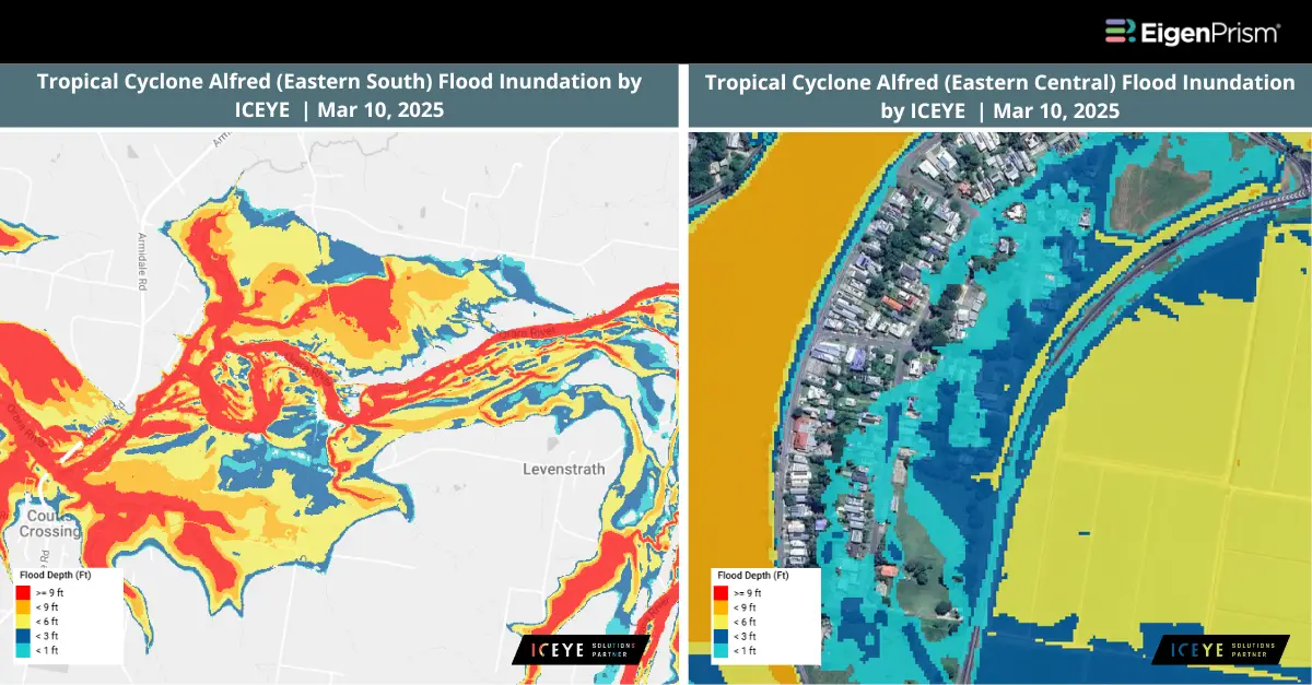
Flood Dataset
Subscribers of ICEYE in EigenPrism can assess the impact of flooding, using the following report template:
Tropical Cyclone Alfred – Flood Inundation by ICEYE Report Template
This report template enables you to assess the impact of the flood inundation based on the footprints from ICEYE. The footprints display the following: Tropical Cyclone Alfred flood inundation across the southern east, central east, and northern east of Australia.
Windstorm Dataset
All EigenPrism® users can assess the impact of the tropical cyclone using the following report template:
Tropical Cyclone Post-Event Impact Report Template
This report template enables you to assess the impact of the tropical cyclone based on the footprints from Adiabat & Hurricane Mapping. The footprints display the following: Tropical Cyclone Past Maximum Winds and Tropical Cyclone Past Wind Swaths. The pages auto-update with the latest available data.
Alerts
Users who have alerts set on their exposures for the relevant event sets, like those from Adiabat & Hurricane Mapping will receive alerts (if the event footprints impact these exposures).
To learn more about how to set an alert on a specific event set, check out this help center article.
Feel free to contact us at Prism.Support@eigenrisk.com or reach out directly to your Customer Success Manager with any questions or concerns. Our team is here to assist you with setting alerts, understanding report templates, and maximizing the actionable insights available through EigenPrism®.
Mar 07 | Tropical Cyclone Alfred Set to Approach Queensland, Bringing Damaging Winds and Flooding
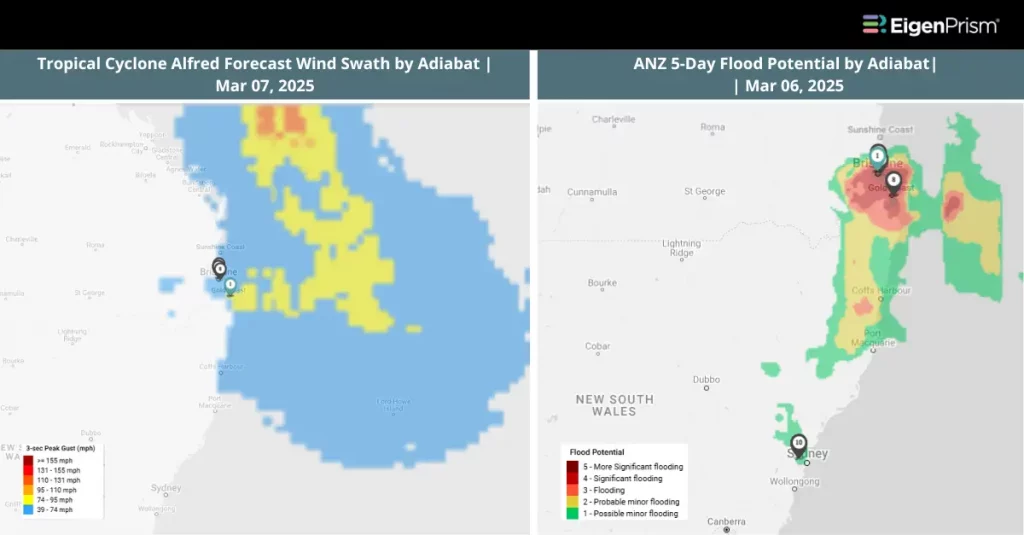
Over 80,000 residents across two states are without power as Tropical Cyclone Alfred intensifies, bringing damaging winds, towering waves, and torrential rain to coastal regions.
The storm is expected to make landfall as a Category 2 cyclone on Saturday morning in southeast Queensland. Wind gusts near the storm’s core could reach 155 km/h (96 mph), potentially uprooting trees, disrupting transportation, and causing widespread power outages.
Forecasts indicate heavy rainfall ranging from 100-200 mm (4-8 inches) across southern Queensland and northern New South Wales, with some areas predicted to receive up to 700 mm (28 inches). The deluge will increase the risk of severe flooding, potentially triggering landslides in vulnerable areas.
Actionable Analytics on EigenPrism
Forecast
Windstorm and Flood Dataset
All EigenPrism® users can assess the forecast of the tropical cyclone using the following report template:
Tropical Cyclone Alfred, March 2025, Forecast Impact Report Template
This report template enables you to assess the forecast of the tropical cyclone based on the footprints from Adiabat & Hurricane Mapping. The footprints display the following: Tropical Cyclone Forecast: Wind Swaths and 5-Day & 3-Day ANZ Flood Potential. The pages auto-update with the latest available data.
Post-Event
Windstorm Dataset
All EigenPrism® users can assess the impact of the tropical cyclone using the following report template:
Tropical Cyclone Post-Event Impact Report Template
This report template enables you to assess the impact of the tropical cyclone based on the footprints from Adiabat & Hurricane Mapping. The footprints display the following: Tropical Cyclone Past Maximum Winds and Tropical Cyclone Past Wind Swaths. The pages auto-update with the latest available data.
Alerts
Users who have alerts set on their exposures for the relevant event sets, like those from Adiabat & Hurricane Mapping will receive alerts (if the event footprints impact these exposures).
To learn more about how to set an alert on a specific event set, check out this help center article.
Feel free to contact us at Prism.Support@eigenrisk.com or reach out directly to your Customer Success Manager with any questions or concerns. Our team is here to assist you with setting alerts, understanding report templates, and maximizing the actionable insights available through EigenPrism®.
Mar 03 | Tropical Cyclone Alfred to Make Landfall Between Brisbane and Sunshine Coast as Category 2 Storm
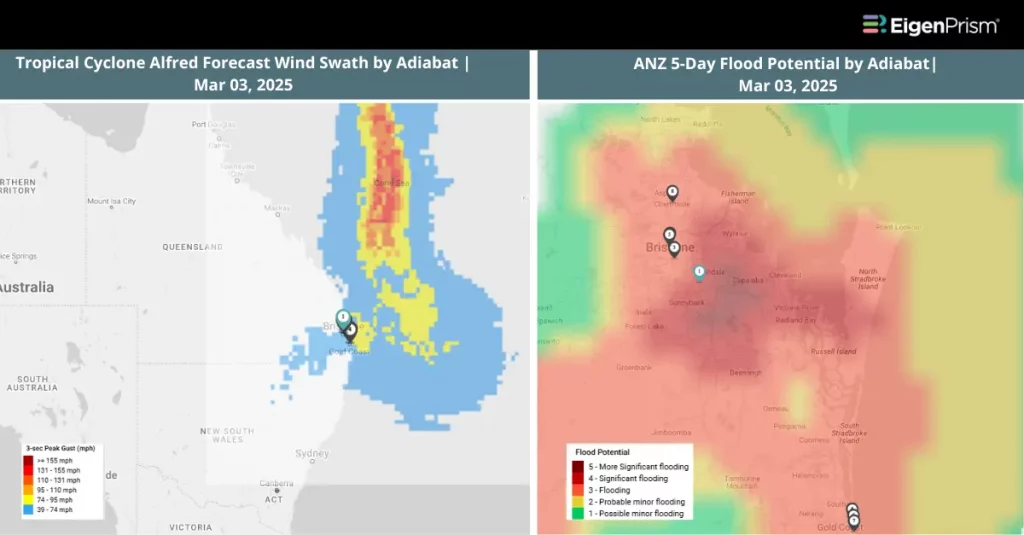
Tropical Cyclone Alfred is expected to become a Category 2 storm as it moves closer to the Queensland coast overnight. For almost two weeks, Tropical Cyclone Alfred has been lingering over the Coral Sea.
According to the Bureau of Meteorology’s latest forecast, released Monday evening, Alfred is expected to sustain its Category 2 strength and make landfall between Brisbane and the Sunshine Coast late Thursday or early Friday.
Coastal regions are bracing for damaging gales, with wind gusts reaching up to 120 km/h. Meanwhile, heavy rainfall of 200 to 400 mm per day is predicted, raising significant concerns about widespread flooding in Queensland. Residents in New South Wales are warned of strong winds, powerful swells, and flash flooding from Byron Bay to the Coffs Coast.
Actionable Analytics on EigenPrism
Forecast
Windstorm and Flood Dataset
All EigenPrism® users can assess the forecast of the tropical cyclone using the following report template:
Tropical Cyclone Alfred, March 2025, Forecast Impact Report Template
This report template enables you to assess the forecast of the tropical cyclone based on the footprints from Adiabat & Hurricane Mapping. The footprints display the following: Tropical Cyclone Forecast: Wind Swaths and 5-Day & 3-Day ANZ Flood Potential. The pages auto-update with the latest available data.
Post-Event
Windstorm Dataset
All EigenPrism® users can assess the impact of the tropical cyclone using the following report template:
Tropical Cyclone Post-Event Impact Report Template
This report template enables you to assess the impact of the tropical cyclone based on the footprints from Adiabat & Hurricane Mapping. The footprints display the following: Tropical Cyclone Past Maximum Winds and Tropical Cyclone Past Wind Swaths. The pages auto-update with the latest available data.
Alerts
Users who have alerts set on their exposures for the relevant event sets, like those from Adiabat & Hurricane Mapping will receive alerts (if the event footprints impact these exposures).
To learn more about how to set an alert on a specific event set, check out this help center article.
Feel free to contact us at Prism.Support@eigenrisk.com or reach out directly to your Customer Success Manager with any questions or concerns. Our team is here to assist you with setting alerts, understanding report templates, and maximizing the actionable insights available through EigenPrism®.