Jan 22 | Rare Winter Storm Brings Deadly Cold, Heavy Snow, and Ice Across the South
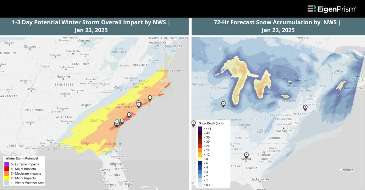
Frigid temperatures gripped the southern US as a powerful winter storm is spreading heavy snow and dangerous ice from Texas to northern Florida. The storm has already claimed at least nine lives as it wreaks havoc along the Gulf Coast.
More than 40 million people across the South were under various weather alerts, with over 21 million placed under winter storm warnings. Houston to Alabama saw widespread snow accumulations of 3 to 6 inches, while some locations recorded more than 10 inches. The National Weather Service reported that Louis Armstrong New Orleans International Airport measured 8 inches of snow on Tuesday, an exceptionally rare event for the region.
Actionable Analytics on EigenPrism
Winter Storm Datasets
Post-Event
All EigenPrism® users can assess the post-event impact of the snow accumulation as of Jan 22, 2025, using the following event footprint:
72-hour observed snow accumulation as of Jan 22, 2025, by NWS
Forecast
All EigenPrism® users can assess the forecasts associated with this event using the following report templates:
US Winter Storm Forecast Template
This report template enables you to assess the forecast of the winter storm based on footprints from NWS. The report consists of 72-hr Forecast Freezing Rain Accumulation, 72-hr Forecast Snow Accumulation, and Potential Winter Storm Overall Impact. The pages auto-update with the latest available data.
Winter Severity Component Report Template
This report template enables you to assess the summary level forecast (Potential Overall Winter Storm Impact) and all six component WSSI (Winter Storm Severity Index) footprints from NWS. The six component WSSI footprints consist of Potential Snow Amount Impact, Snow Load Impact, Ground Blizzard Impact, Ice Accumulation Impact, Blowing Snow Impact and Winter Storm Flash Freeze Impact. The report template pages auto-update with the latest available data.
Alerts
Users who have alerts set on their exposures for the relevant event sets, like those from NWS, will receive alerts (if the event footprints impact these exposures).
To learn more about which winter storm event sets to set alerts on, check out this help center article.
To learn more about how to set an alert on a specific event set, check out this help center article.
Jan 21 | Arctic Blast Sweeps Across Southern US, Bringing Snow, Ice, and Dangerous Cold
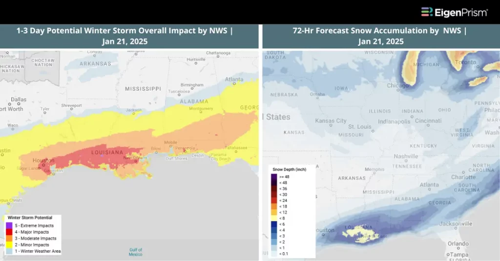
More than 220 million people across the U.S. are bracing for extreme cold as a powerful winter storm combines with frigid air, bringing snow, freezing rain, and hazardous road conditions. The storm is expected to cause significant travel disruptions from late Monday through Wednesday morning, affecting southern cities from Texas to South Carolina—regions where severe winter weather is uncommon.
Widespread snow accumulations of 1 to 3 inches are expected from southeast Texas—including Houston—through southern Louisiana, southern Georgia, and coastal South Carolina. Some areas, particularly in far southeast Texas and southern Louisiana, including Baton Rouge and New Orleans, could see over 3 inches of snowfall.
Actionable Analytics on EigenPrism
Winter Storm Datasets
Forecast
All EigenPrism® users can assess the forecasts associated with this event using the following report templates:
US Winter Storm Forecast Template
This report template enables you to assess the forecast of the winter storm based on footprints from NWS. The report consists of 72-hr Forecast Freezing Rain Accumulation, 72-hr Forecast Snow Accumulation, and Potential Winter Storm Overall Impact. The pages auto-update with the latest available data.
Winter Severity Component Report Template
This report template enables you to assess the summary level forecast (Potential Overall Winter Storm Impact) and all six component WSSI footprints from NWS. The six component WSSI footprints consist of Potential Snow Amount Impact, Snow Load Impact, Ground Blizzard Impact, Ice Accumulation Impact, Blowing Snow Impact and Winter Storm Flash Freeze Impact. The report template pages auto-update with the latest available data.
Post-Event
All EigenPrism® users can assess the post-event impact of the snow accumulation as of Jan 21, 2025, using the following event footprint:
72-hour observed snow accumulation as of Jan 21, 2025, by NOHRSC
Alerts
Users who have alerts set on their exposures for the relevant event sets, like those from NWS, will receive alerts (if the event footprints impact these exposures).
To learn more about which event sets to set alerts on, check out this help center article.
To learn more about how to set an alert on a specific event set, check out this help center article.
Jan 20 | Severe Winter Storm Threatens Southern US With Snow, Ice, and Strong Winds
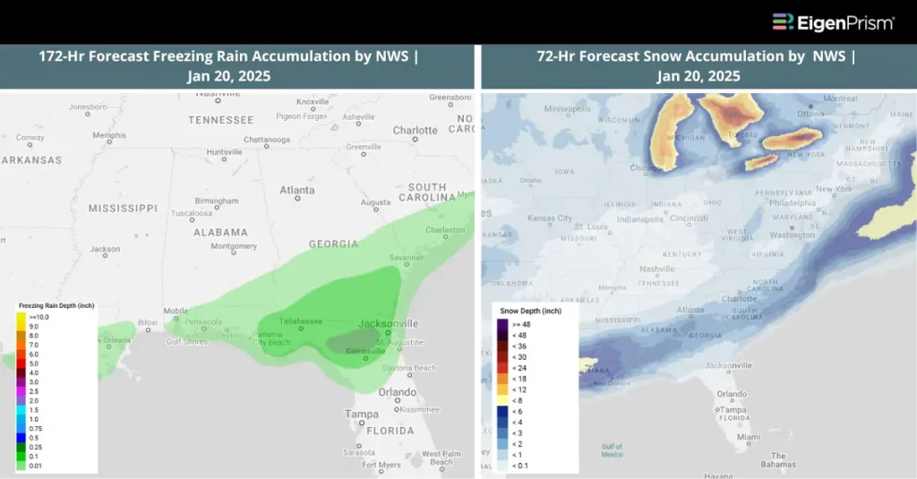
The National Weather Service has issued winter storm alerts spanning from central and eastern Texas to parts of Georgia, including major cities such as Houston, New Orleans, Tallahassee, and sections of the Atlanta metro area.
The first major clash of cold air and moisture is expected over Texas and Louisiana late Monday, setting the stage for hazardous winter conditions. A mix of snow, sleet, and freezing rain is anticipated, particularly near and south of Interstate 20, extending toward the Gulf Coast.
Several major Texas cities, including Houston, San Antonio, Austin, and Corpus Christi, could experience snow and icy conditions. These alerts indicate that the combination of snow, ice, and gusty winds may create treacherous travel conditions early in the week, with roads becoming slick or impassable.
Actionable Analytics on EigenPrism
Winter Storm Datasets
Forecast
All EigenPrism® users can assess the forecasts associated with this event using the following report templates:
US Winter Storm Forecast Template
This report template enables you to assess the forecast of the winter storm based on footprints from NWS. The report consists of 72-hr Forecast Freezing Rain Accumulation, 72-hr Forecast Snow Accumulation, and Potential Winter Storm Overall Impact. The pages auto-update with the latest available data.
Winter Severity Component Report Template
This report template enables you to assess the forecast of the summary level (Potential Overall Winter Storm Impact) and all six component WSSI footprints from NWS. The six component WSSI footprints consist of Potential Snow Amount Impact, Snow Load Impact, Ground Blizzard Impact, Ice Accumulation Impact, Blowing Snow Impact and Winter Storm Flash Freeze Impact. The pages auto-update with the latest available data.
Post-Event
All EigenPrism® users can assess the post-event impact of the snow accumulation using the following event footprint:
72-hour observed snow accumulation as of Jan 20, 2025, by NOHRSC
Alerts
Users who have alerts set on their exposures for the relevant event sets, like those from NWS, will receive alerts (if the event footprints impact these exposures).
To learn more about which event sets to set alerts, check out this help center article.
To learn more about how to set an alert on a specific event set, check out this help center article.
Feel free to contact us at Prism.Support@eigenrisk.com or reach out directly to your Customer Success Manager with any questions or concerns. Our team is here to assist you with setting alerts, understanding report templates, and maximizing the actionable insights available through EigenPrism®.