Tornadoes Ravage Oklahoma, Texas, Missouri, and Louisiana
Severe thunderstorms erupted again on Monday and are projected to continue overnight from northeastern Texas to southwestern Missouri. Multiple Tornado Watches and Warnings were issued across the high-risk areas. On Monday afternoon, the National Weather Service reported a wind gust reaching 94 mph in Talala, Oklahoma, as a tornado-warned storm passed through the region.
By Monday evening, there were at least three tornado reports in parts of northeastern Oklahoma and northwestern Arkansas. One tornado north of Tulsa was described by the National Weather Service as “large, extremely dangerous, and potentially deadly.”
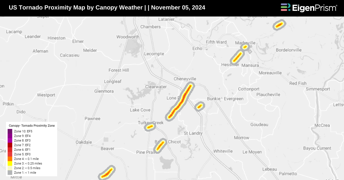
An EF-1 tornado struck near Basile, Louisiana, on Tuesday morning, injuring three people, according to the National Weather Service. The twister had estimated peak wind speeds of 95 mph and carved a path 1 mile long and 150 yards wide. It touched down along U.S. Highway 190, just west of the town, which has a population of slightly over 1,200 residents.
Damage to homes was reported about three miles west of Sperry, Oklahoma, on Monday afternoon, which officials referred to as “potential tornado damage. The storms also knocked down telephone poles, snapped trees, and scattered debris across affected areas, including large pieces of wood and metal from destroyed buildings.
Tornadoes Ravage Oklahoma, Texas, Missouri, and Louisiana: Actionable Analytics on EigenPrism
Post-Event
Tornado
All EigenPrism® users can assess the post-event impact of the tornado from Nov 04-05, 2024, using the following report template:
US Tornado from Nov 04-05, 2024 Post Event Report Template
This report template includes the major tornadoes from Nov 04-05, 2024. You can find all the available damage surveys in the model catalog.
- EF1 Tornado Track in Broken Bow, Oklahoma City by NWS
- EF1 Tornado Track near Avery, Texas by NWS
- EF0 Tornado Track in Spring field, Missouri City by NWS
- EF1 Tornado Track in Basile, Louisiana By NWS
- EF1 Tornado Track in Bayou, Louisiana by NWS
- 24-hr Tornado Reports by NOAA
Canopy Weather
Subscribers of Canopy Weather can assess the impact of the tornadoes, from Nov 05 using these footprints within EigenPrism®:
US Tornado Proximity Map as of 2024-11-05
Nov 04 | Tornadoes Devastate Oklahoma City, Leaving 11 Injured, Widespread Destruction, and Thousands Without Power
 Severe thunderstorms unleashed tornadoes and flooding across Oklahoma on Saturday night, continuing into Sunday morning, injuring at least 11 people and causing widespread destruction to homes and other structures. According to the National Weather Service, as many as 12 tornadoes may have touched down across the state.
Although no fatalities have been reported, around 100 homes were damaged. In addition to damaged structures, downed power lines, broken traffic lights, and uprooted trees have also been reported, according to the Oklahoma City Fire Department. One tornado is believed to have directly impacted Oklahoma City, where most of the injuries occurred. City officials reported that 39 buildings were destroyed, 43 sustained major damage, and 54 suffered minor damage.
The extent of the damage is still being assessed, but the National Weather Service field office in Norman confirmed that one tornado in Harrah, Oklahoma, produced EF3-level damage with winds between 136-165 mph, while another in Newcastle reached EF1-level damage with winds of 86-110 mph. As of Sunday afternoon, more than 20,000 customers in Oklahoma and Texas were without power, including 5,000 residents in Oklahoma City alone, according to PowerOutage.us.
Severe weather is expected to continue into Monday, with central to eastern Oklahoma, parts of northwestern Arkansas, and southern Missouri expected to receive heavy rain, according to a National Weather Service advisory. The main threats include damaging winds, large hail, and tornadoes. Thunderstorms are producing rainfall rates of about 1 inch per hour in parts of southeastern Oklahoma, prompting federal forecasters to issue flash flood warnings. By Monday night, the severe weather threat will shift eastward, impacting areas in Arkansas, Louisiana, Texas, the mid-Mississippi Valley, and the Midwest.
Tornadoes Devastate Oklahoma City: Actionable Analytics on EigenPrism
Post-Event
Tornado & Hail
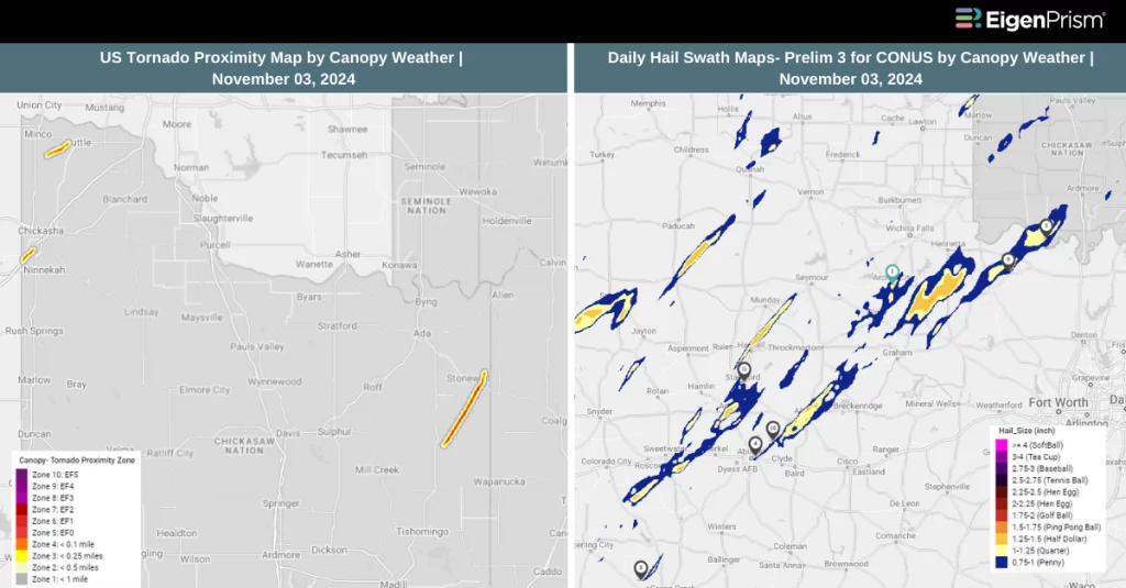
All EigenPrism® users can assess the post-event impact of tornado and hail from Nov 03, 2024, using the following report template:
US Tornado & Hail for Nov 03, 2024 Post Event Report Template
This report template includes the major tornadoes from Nov 03, 2024. You can find all the available damage surveys in the model catalog.
- EF3 Tornado Track in Harrah, Oklahoma City by NWS
- EF2 Tornado Track in Valley Brook, Oklahoma City By NWS
- EF1 Tornado Track in Byers, Texas by NWS
- 24-hr Tornado Reports by NOAA
The report template also contains the latest available hail footprints, which include:
- 24-Hr Hail Mesh Swath by NSSL
Canopy Weather
Subscribers of Canopy Weather can assess the impact of the tornadoes, hail & wind from Nov 03 using these footprints within EigenPrism®:
US Tornado Proximity Map as of 2024-11-03
Daily CONUS Hail Swath Map – Prelim 3 as of 2024-11-03
Daily CONUS Peak Wind Gusts- Prelim 3 as of 2024-11-03
Forecast
All EigenPrism® users can assess the forecast of this multi-peril event using the following report template:
US Severe Weather 2024 Forecast Report
The report template auto-updates with the latest available footprints, which include:
- Significant Tornado Day 1 Outlook
- Significant Hail Day 1 Outlook
- Significant Wind Day 1 Outlook
- WPC 3-Day Excessive Rainfall Outlook
- NA 5-day Flood Potential
- NA 3-day Flood Potential
- US Flood Outlook
Oct 31 | Severe Storms Bring Tornado and Damaging Wind Threats to Over 12 Million People Across the Central Plains
Severe storms erupted early Wednesday afternoon across parts of Kansas and Nebraska, quickly advancing into areas of Iowa and Missouri. These thunderstorms are expected to intensify and expand throughout the Thursday late afternoon and early evening, with significant risks including damaging wind gusts, large hail, and a few tornadoes—some potentially reaching EF2 strength or higher.
A possible tornado impacted areas of Prairie Grove. Several homes along Sundowner Ranch Drive near Colonel Soloman Road sustained damage, with additional reports of destruction along Sedgwich at South Bagget. The Prairie Grove Police Department also confirmed that the city’s aquatic park and baseball park suffered damage
Meanwhile, a level 3 of 5 threat for severe thunderstorms from the Storm Prediction Center is in effect for over 5 million people, including those in Kansas City, and Tulsa, Oklahoma. Although the tornado risk is lower in this region, isolated tornadoes remain possible, along with the threats of damaging winds and large hail, which could impact over 12 million residents.
80 mph wind gust was recorded in central Oklahoma Wednesday afternoon as storms swept northeastward. Ahead of Halloween, severe weather may also occur within a narrow zone stretching from the Midwest to East Texas. The National Weather Service (NWS) warns of the possibility of small tornadoes from as far north as Maryville to as far south as Pittsburg, with the risk zone extending westward to Emporia and eastward to Harrisonville.
Severe Storms Bring Tornado and Damaging Wind Threats: Actionable Analytics on EigenPrism
Post-Event
Tornado
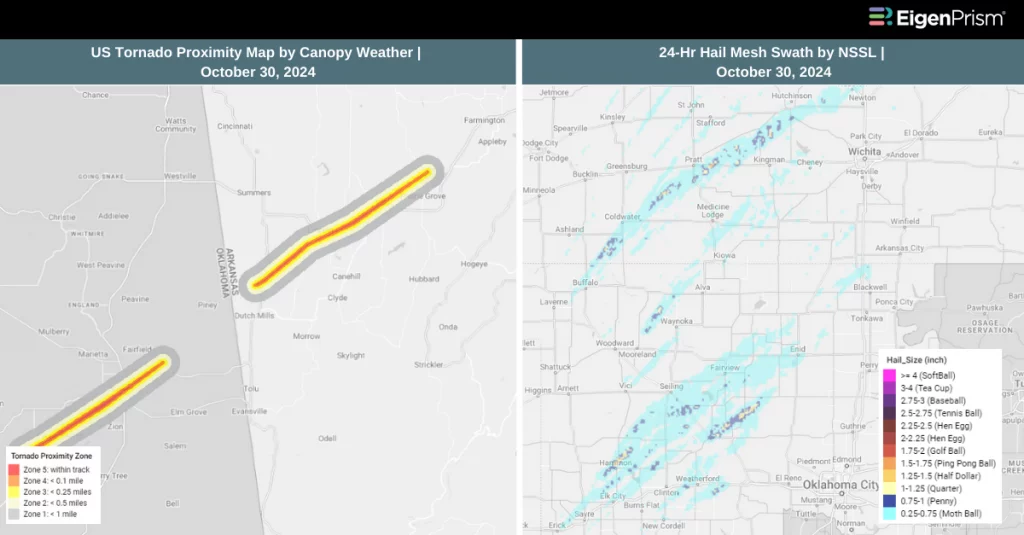
Subscribers of Canopy Weather can assess the impact of the tornadoes, using this footprint within EigenPrism®:
US Tornado Proximity Map as of 2024-10-30
Hail
All EigenPrism® users can assess the impact of the hail from Oct 30, 2024, using this footprint within EigenPrism®
24-Hr Hail Mesh Swath by NSSL Ending as of 2024-10-30
Forecast
Tornado
All EigenPrism® users can assess the tornado outlook released by NWS, using this footprint within EigenPrism®:
Significant Tornado Day 1 Outlook as of 2024-10-31
Hail
All EigenPrism® users can assess the hail outlook released by NWS, using this footprint within EigenPrism®:
Significant Hail Day 1 Outlook as of 2024-10-30
Oct 30 | Severe Thunderstorms Expected to Hit Kansas City with Tornadoes, Hail, and Damaging Winds
Severe thunderstorms are expected to impact Kansas City and surrounding areas on Wednesday, with an elevated risk of tornadoes, damaging winds, and large hail. The storm system is forecasted to extend from the Corn Belt down through the Southern Plains, bringing potentially hazardous conditions as midweek approaches.
The National Weather Service’s Storm Prediction Center has placed northwestern Missouri, eastern Kansas, and northeastern Oklahoma in an “enhanced risk” zone, the third highest on their five-tier scale for severe weather.
Storms are forecasted to develop across eastern Nebraska, northwestern Kansas, and western Iowa by late Wednesday morning. As the day progresses, these storms are expected to extend northeast into the upper Mississippi Valley and southward across eastern Kansas. The Storm Prediction Center highlighted areas including Kansas City, Topeka, and eastern Kansas with a 10% probability of a tornado occurring within 25 miles of any given point.
Severe Thunderstorms Expected to Hit Kansas City: Actionable Analytics on EigenPrism
Forecast
All EigenPrism® users can assess the tornado outlook released by NWS, using this footprint within EigenPrism®:
Significant Tornado Day 1 Outlook as of 2024-10-30
Escape the News Cycle | Get Alerts Automatically for Events Impacting Your Assets
With EigenPrism Alerts, you can free yourself from constant event monitoring. Set up personalized alerts based on predefined impact thresholds and choose how you receive them – via email, SMS, or directly within EigenPrism. This way, you can stay informed on your own terms, focusing only on the events that truly matter to your assets.
Set your alerts now.
Don’t have access to EigenPrism®?
Sign up for a trial account and access full impact reports of all events. Contact us, and we’ll set up a trial account for you.