Series of Tornadoes cause chaos in Maryland and Washington, D.C.
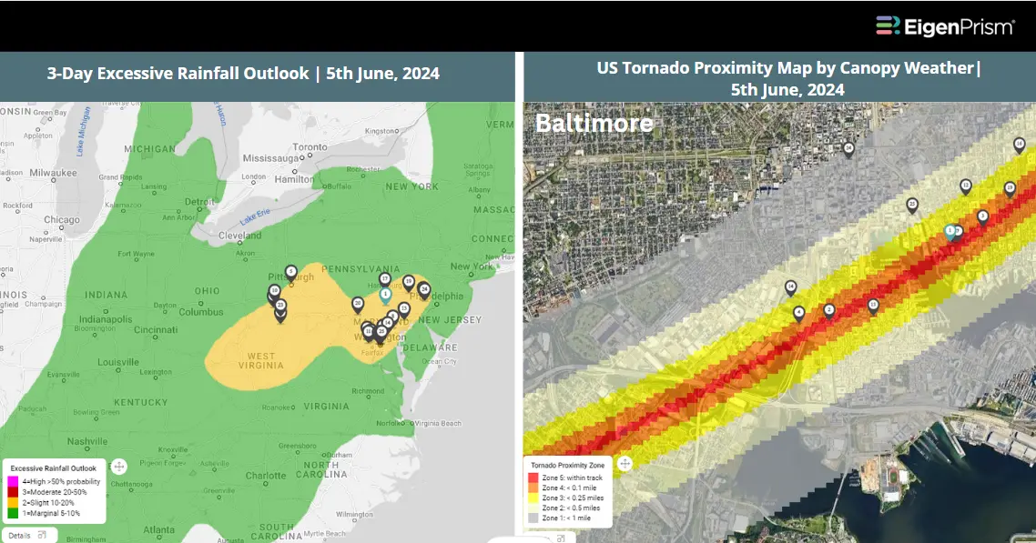
Storms in the US midwest and on the east coast caused chaos on Wednesday. Tornadoes swept through Maryland and Virginia on Wednesday evening, leaving a line of damage for at least 45 miles. The National Weather Service issued a tornado warning for central Montgomery County Wednesday evening after a confirmed tornado was located near Poolesville, Maryland — about 20 miles northwest of Washington, D.C.. The neighborhood most impacted was East Deer Park. Some minor injuries, but no loss of life was reported. Tornado warnings were issued throughout the state and in Delaware on Wednesday night. The NWS also issued Flood Watches for the Baltimore and Washington areas due to the risk of heavy rain from the systems moving through the region.
Series of Tornadoes cause severe destruction in Maryland and Washington DC: Actionable Insights on EigenPrism
Post-Event
Subscribers of Canopy Weather can assess the impact of this multi-peril event using the following report template:
US Tornado, Hail and Wind From Canopy Weather – Template
This report template contains the latest available footprints, which include
- Tornado Proximity Map
- Daily Hail Swath Map
- Daily Peak Wind Gusts
Tornado
Subscribers of Canopy Weather in EigenPrism can assess the impact of the tornadoes from June 5, 2024, using this footprint within EigenPrism®
US Tornado Proximity Map as of 2024-06-05
All EigenPrism® users can assess the post-event impact of tornadoes and hail using the following report template:
US Tornado & Hail June 05, 2024 Post Event Impact Report – Template
This report template contains the latest available footprints, which include:
- 24-Hr Tornado Report Ending
- 24-Hr Rotational Track
- 24-Hr Hail Swath Ending
Note: Tornado damage survey footprints are typically released by NWS a few days after the event and will be available in EigenPrism as soon as they are released.
Forecast
All EigenPrism® users can assess the forecast of this multi-peril event using the following report template:
US Severe Weather 2024 Forecast Report
The report template auto-updates with the latest available footprints, which include:
- Significant Tornado Day 1 Outlook
- Significant Hail Day 1 Outlook
- Significant Wind Day 1 Outlook
- WPC 3-Day Excessive Rainfall Outlook
- NA 5-day Flood Potential
- NA 3-day Flood Potential
- US Flood Outlook
Escape the News Cycle | Get Notified Automatically for Events Impacting Your Assets
With EigenPrism Alerts, you can set Alerts and free yourself from constant event monitoring. Set up personalized alerts based on predefined impact thresholds and choose how you receive them – via email, SMS, or directly within EigenPrism. This way, you stay informed on your own terms, focusing only on the events that truly matter to your assets.
Set your alerts now.
Don’t have access to EigenPrism®?
Contact us if you want to learn more