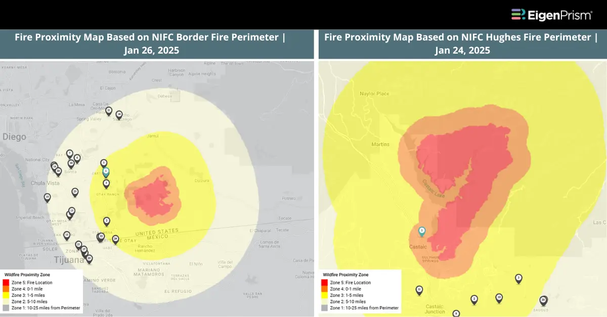
Jan 27 | Southern California Wildfires Update: Border Fire at 40% containment, while Hughes is at 92%
The Border fire, which erupted on Thursday, is now 40% contained, with 6,625 acres burned. The Hughes Fire is 92% contained, with 10,425 acres burned as of Jan 26th afternoon.
Efforts to control the Palisades Fire have reached 90% containment, while the Eaton Fire stands at 98% containment, after consuming 23,448 acres and 14,021 acres, respectively.
For real-time updates on the spread and containment of the fires, visit CAL FIRE
Actionable Analytics on EigenPrism
Alerts
Users who have alerts set on their exposures for the relevant event sets, like those from NIFC and CAL FIRE, will receive alerts (if the event footprints impact these exposures).
The CAL FIRE datasets were recently added to EigenPrism. Please note that these datasets are now also available to set alerts.
Set alerts on the CAL FIRE event sets.
Wildfire Perimeter Datasets
All EigenPrism® users can assess the impact on and near the active fire area using the following report template:
California Wildfires Jan 2025 Impact Report Template
This report template enables you to assess the impact of the wildfires based on footprints from CAL FIRE and NIFC. The footprints display active fire zones and their proximity to the Hughes Fire, Gibble Fire (100% contained), Palisades Fire, Eaton Fire, Hughes Fire, Hurst Fire (100% contained), Auto Fire (100% contained), Kenneth Fire (100% contained), Archer Fire (100% contained), Lidia Fire (100% contained), Sunset Fire (100% contained). The pages auto-update with the latest available data.
Rapid Damage Assessment
ICEYE Building Damage Assessment
Subscribers of ICEYE in EigenPrism can assess the building damage assessment for the Hughes, Palisades, Eaton, and Hurst fires using the following report template:
California Fires ICEYE Jan 2025 Impact Report Template
Vexcel Aerial Imagery
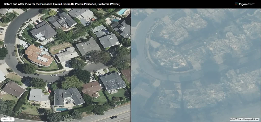
Subscribers of Vexcel in EigenPrism can access the imagery associated with Palisades, Eaton, Kenneth, Sunset, and Hurst Fire zones.
Subscribers of Vexcel in EigenPrism can use this guided tour to learn more about how to use Vexcel in EigenPrism.
NOAA Imagery
NOAA aerial imagery for the California fires is available in EigenPrism as WMS layers.
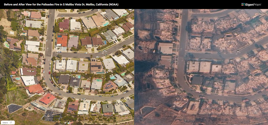
Here’s how you can access the WMS layers:
- On the analysis or report page, click the overlays button in the top right section of the map.
- Click “+Add an Overlay” and choose “Add a WMS layer”.
- Type California Wildfire 2025 Imagery in the search box and choose the relevant layers.
Jan 24 | New Fires Burn in San Diego, Riverside and Ventura; Hughes Fire Scorches 10,000 Acres
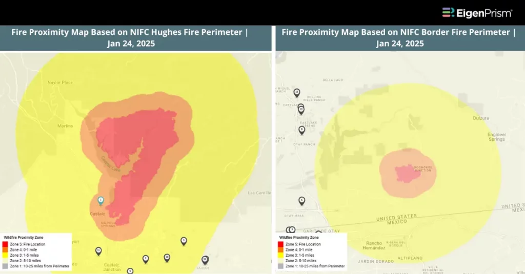
Five new fires erupted in San Diego and Riverside on Thursday, Jan 23, 2025. The largest of these is the Border Fire in San Diego which has currently burnt 4250 acres with 0% containment. Currently, the largest fire in Ventura County is the Laguna Fire having burnt 94 acres at 70% containment.
The Hughes Fire, having scorched 10,396 acres, is at 56% containment. The Palisades Fire is at 75% containment whereas the Eaton Fire remains at 95% containment.
For real-time updates on the spread and containment of the fires, visit CAL FIRE
Actionable Analytics on EigenPrism
Alerts
Users who have alerts set on their exposures for the relevant event sets, like those from NIFC and CAL FIRE, will receive alerts (if the event footprints impact these exposures).
The CAL FIRE datasets were recently added to EigenPrism. Please note that these datasets are now also available to set alerts.
Set alerts on the CAL FIRE event sets.
Wildfire Perimeter Datasets
All EigenPrism® users can assess the impact on and near the active fire area using the following report template:
California Wildfires Jan 2025 Impact Report Template
This report template enables you to assess the impact of the wildfires based on footprints from CAL FIRE and NIFC. The footprints display active fire zones and their proximity to the Hughes Fire, Gibble Fire, Palisades Fire, Eaton Fire, Hughes Fire, Hurst Fire (100% contained), Auto Fire (100% contained), Kenneth Fire (100% contained), Archer Fire (100% contained), Lidia Fire (100% contained), Sunset Fire (100% contained). The pages auto-update with the latest available data.
Rapid Damage Assessment
ICEYE Building Damage Assessment
Subscribers of ICEYE in EigenPrism can assess the building damage assessment for the Hughes, Palisades, Eaton, and Hurst fires using the following report template:
California Fires ICEYE Jan 2025 Impact Report Template
Vexcel Aerial Imagery
Subscribers of Vexcel in EigenPrism can access the imagery associated with Palisades, Eaton, Kenneth, Sunset, and Hurst Fire zones.
Subscribers of Vexcel in EigenPrism can use this guided tour to learn more about how to use Vexcel in EigenPrism.
NOAA Imagery
NOAA aerial imagery for the California fires is available in EigenPrism as WMS layers.
Here’s how you can access the WMS layers:
- On the analysis or report page, click the overlays button in the top right section of the map.
- Click “+Add an Overlay” and choose “Add a WMS layer”.
- Type California Wildfire 2025 Imagery in the search box and choose the relevant layers.
Jan 23 | Hughes Fire Erupts in Ventura County, Eaton Fire at 95% containment and Palisades Fire at 70%
The Hughes Fire which started in Ventura County on Jan 22, Wednesday has currently burnt 10,176 acres (at 14% containment).
The Palisades Fire has now reached 70% containment as of Thursday, Jan 23, burning 23,448 acres, with 6,662 structures destroyed and 890 damaged, while numbers may rise. The Eaton Fire is 95% contained, covering 14,021 acres, with 9,418 structures destroyed and 1,073 damaged.
For real-time updates on the spread and containment of the fires, visit CAL FIRE
Actionable Analytics on EigenPrism
Alerts
Users who have alerts set on their exposures for the relevant event sets, like those from NIFC and CAL FIRE, will receive alerts (if the event footprints impact these exposures).
The CAL FIRE datasets were recently added to EigenPrism. Please note that these datasets are now also available to set alerts.
Set alerts on the CAL FIRE event sets.
Wildfire Perimeter Datasets
All EigenPrism® users can assess the impact on and near the active fire area using the following report template:
California Wildfires Jan 2025 Impact Report Template
This report template enables you to assess the impact of the wildfires based on footprints from CAL FIRE and NIFC. The footprints display active fire zones and their proximity to the Palisades Fire, Eaton Fire, Hughes Fire, Hurst Fire (100% contained), Auto Fire (100% contained), Kenneth Fire (100% contained), Archer Fire (100% contained), Lidia Fire (100% contained), Sunset Fire (100% contained). The pages auto-update with the latest available data.
Rapid Damage Assessment
ICEYE Building Damage Assessment
Subscribers of ICEYE in EigenPrism can assess the building damage assessment for the Hughes, Palisades, Eaton, and Hurst fires using the following report template:
California Fires ICEYE Jan 2025 Impact Report Template
Vexcel Aerial Imagery
Subscribers of Vexcel in EigenPrism can access the imagery associated with Palisades, Eaton, Kenneth, Sunset, and Hurst Fire zones.
Subscribers of Vexcel in EigenPrism can use this guided tour to learn more about how to use Vexcel in EigenPrism.
NOAA Imagery
NOAA aerial imagery for the California fires is available in EigenPrism as WMS layers.
Here’s how you can access the WMS layers:
- On the analysis or report page, click the overlays button in the top right section of the map.
- Click “+Add an Overlay” and choose “Add a WMS layer”.
- Type California Wildfire 2025 Imagery in the search box and choose the relevant layers.
Jan 20 | Palisades and Eaton Fires: Containment Grows, but Santa Ana Winds Pose Renewed Threats
The Palisades Fire has now reached 56% containment as of Sunday, Jan 19, burning 23,713 acres, with 5,829 structures destroyed and 744 damaged, while numbers may rise. The Eaton Fire is 81% contained, covering 14,021 acres, with 9,391 structures destroyed and 1,063 damaged.
Meanwhile, worsening Santa Ana winds threaten further fire spread across Los Angeles and Ventura counties, including Malibu and Altadena starting Monday.
For real-time updates on the spread and containment of the fires, visit CAL FIRE
Actionable Analytics on EigenPrism
Alerts
Users who have alerts set on their exposures for the relevant event sets, like those from NIFC and CAL FIRE, will receive alerts (if the event footprints impact these exposures).
The CAL FIRE datasets were recently added to EigenPrism. Please note that these datasets are now also available to set alerts.
Set alerts on the CAL FIRE event sets.
Wildfire Perimeter Datasets
All EigenPrism® users can assess the impact on and near the active fire area using the following report template:
California Wildfires Jan 2025 Impact Report Template
This report template enables you to assess the impact of the wildfires based on footprints from CAL FIRE and NIFC. The footprints display active fire zones and their proximity to the Palisades Fire, Eaton Fire, Hurst Fire, Auto Fire, Kenneth Fire, Archer Fire, Lidia Fire, and Sunset Fire. The pages auto-update with the latest available data.
Rapid Damage Assessment
ICEYE Building Damage Assessment
Subscribers of ICEYE in EigenPrism can assess the building damage assessment for the Palisades, Eaton, and Hurst fires using the following report template:
California Fires ICEYE Jan 2025 Impact Report Template
Vexcel Aerial Imagery
Subscribers of Vexcel in EigenPrism can access the imagery associated with Palisades, Eaton, Kenneth, Sunset, and Hurst Fire zones.
Subscribers of Vexcel in EigenPrism can use this guided tour to learn more about how to use Vexcel in EigenPrism.
NOAA Imagery
NOAA aerial imagery for the California fires is available in EigenPrism as WMS layers.
Here’s how you can access the WMS layers:
- On the analysis or report page, click the overlays button in the top right section of the map.
- Click “+Add an Overlay” and choose “Add a WMS layer”.
- Type California Wildfire 2025 Imagery in the search box and choose the relevant layers.
Wind Speed Footprints
Adiabat Daily Peak Wind Gust
All EigenPrism® users can assess the impact of wind using the following footprint:
Daily Peak Wind Gust across North America for Jan 19, 2025
Canopy Weather Peak Wind Gust
Subscribers of Canopy Weather in EigenPrism® can assess the impact of wind using the following footprint:
Daily CONUS Peak Wind Gusts- Prelim 3 as of Jan 19, 2025
Jan 15 | Palisades and Eaton Fires Persist, Auto Fire Reaches 47% Containment
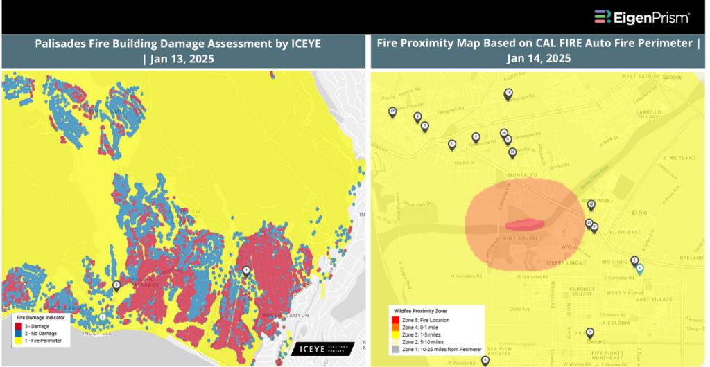
The Palisades and Eaton fires remain largely uncontained, with the Palisades Fire burning 23,713 acres at 18% containment and the Eaton Fire burning 14,117 acres at 35% containment. The Hurst Fire, at 799 acres, is nearly fully controlled with 97% containment. Meanwhile, the Auto Fire in Ventura County has burned 61 acres with 47% containment.
For real-time updates on the spread and containment of the fires, visit CAL FIRE
Actionable Analytics on EigenPrism
Alerts
Users who have alerts set on their exposures for the relevant event sets, like those from NIFC and CAL FIRE, will receive alerts (if the event footprints impact these exposures).
The CAL FIRE datasets were recently added to EigenPrism. Please note that these datasets are now also available to set alerts.
Set alerts on the CAL FIRE event sets.
Wildfire Perimeter Datasets
All EigenPrism® users can assess the impact on and near the active fire area using the following report template:
California Wildfires Jan 2025 Impact Report Template
This report template enables you to assess the impact of the wildfires based on footprints from CAL FIRE and NIFC. The footprints display active fire zones and their proximity to the Palisades Fire, Eaton Fire, Hurst Fire, Auto Fire, Kenneth Fire, Archer Fire, Lidia Fire, and Sunset Fire. The pages auto-update with the latest available data.
Rapid Damage Assessment
ICEYE Building Damage Assessment
Subscribers of ICEYE in EigenPrism can assess the building damage assessment for the Palisades, Eaton, and Hurst fires using the following report template:
California Fires ICEYE Jan 2025 Impact Report Template
Vexcel Aerial Imagery
Subscribers of Vexcel in EigenPrism can access the imagery associated with Palisades, Eaton, Kenneth, Sunset, and Hurst Fire zones.
Subscribers of Vexcel in EigenPrism can use this guided tour to learn more about how to use Vexcel in EigenPrism.
NOAA Imagery
NOAA aerial imagery for the California fires is available in EigenPrism as WMS layers.
Here’s how you can access the WMS layers:
- On the analysis or report page, click the overlays button in the top right section of the map.
- Click “+Add an Overlay” and choose “Add a WMS layer”.
- Type California Wildfire 2025 Imagery in the search box and choose the relevant layers.
Wind Speed Footprints
Adiabat Daily Peak Wind Gust
All EigenPrism® users can assess the impact of wind using the following footprint:
Daily Peak Wind Gust across North America for Jan 15, 2025
Canopy Weather Peak Wind Gust
Subscribers of Canopy Weather in EigenPrism® can assess the impact of wind using the following footprint:
Daily CONUS Peak Wind Gusts- Prelim 3 as of Jan 14, 2025
Feel free to contact us at Prism.Support@eigenrisk.com or reach out directly to your Customer Success Manager with any questions or concerns. Our team is here to assist you with setting alerts, understanding report templates, and maximizing the actionable insights available through EigenPrism®.
Jan 14 | Eaton and Palisades Fires Largely Uncontained, Auto Fire Breaks Out in Ventura County
The Palisades and Eaton fires still remain largely uncontained. The Hurst fire is under control at 97% containment. A new fire named Auto fire broke out in Ventura County.
Here’s the latest update on the fires:
- Palisades Fire: 23,713 acres burned, 14% contained
- Eaton Fire: 14,117 acres burned, 33% contained
- Hurst Fire: 799 acres burned, 97% contained
- Auto Fire: 46 acres burned, 0% contained
For real-time updates on the spread and containment of the fires, visit CAL FIRE
Actionable Analytics on EigenPrism
Alerts
Users who have alerts set on their exposures for the relevant event sets, like those from NIFC and CAL FIRE, will receive alerts (if the event footprints impact these exposures).
The CAL FIRE datasets were recently added to EigenPrism. Please note that these datasets are now also available to set alerts.
Set alerts on the CAL FIRE event sets.
Wildfire Perimeter Datasets
All EigenPrism® users can assess the impact on and near the active fire area using the following report template:
California Wildfires Jan 2025 Impact Report Template
This report template enables you to assess the impact of the wildfires based on footprints from CAL FIRE and NIFC. The footprints display active fire zones and their proximity to the Palisades Fire, Eaton Fire, Hurst Fire, Auto Fire, Kenneth Fire, Archer Fire, Lidia Fire, and Sunset Fire. The pages auto-update with the latest available data.
Rapid Damage Assessment
ICEYE Building Damage Assessment
Subscribers of ICEYE in EigenPrism can assess the building damage assessment for the Palisades, Eaton, and Hurst fires using the following report template:
California Fires ICEYE Jan 2025 Impact Report Template
Vexcel Aerial Imagery
Subscribers of Vexcel in EigenPrism can access the imagery associated with Palisades, Eaton, Kenneth, Sunset, and Hurst Fire zones.
Subscribers of Vexcel in EigenPrism can use this guided tour to learn more about how to use Vexcel in EigenPrism.
NOAA Imagery
NOAA aerial imagery for the California fires is available in EigenPrism as WMS layers.
Here’s how you can access the WMS layers:
- On the analysis or report page, click the overlays button in the top right section of the map.
- Click “+Add an Overlay” and choose “Add a WMS layer”.
- Type California Wildfire 2025 Imagery in the search box and choose the relevant layers.
Wind Speed Footprints
Adiabat Daily Peak Wind Gust
All EigenPrism® users can assess the impact of wind using the following footprint:
Daily Peak Wind Gust across North America for Jan 13, 2025
Canopy Weather Peak Wind Gust
Subscribers of Canopy Weather in EigenPrism® can assess the impact of wind using the following footprint:
Daily CONUS Peak Wind Gusts- Prelim 3 as of Jan 14, 2025
Feel free to contact us at Prism.Support@eigenrisk.com or reach out directly to your Customer Success Manager with any questions or concerns. Our team is here to assist you with setting alerts, understanding report templates, and maximizing the actionable insights available through EigenPrism®.
Jan 13 | Eaton and Palisades Fires Remain Uncontrolled Amid Rising Winds and Growing Devastation
The two largest wildfires currently raging in Los Angeles, the Eaton and Palisades fires, remain largely uncontrolled as of the past 24 hours. With winds picking up again on Sunday night and expected to remain strong for several days, fire crews face a difficult battle against both the Palisades and Eaton Fires.
Here’s the latest update on the fires:
- Palisades Fire: 23,713 acres burned, 13% contained
- Eaton Fire: 14,117 acres burned, 27% contained
- Hurst Fire: 799 acres burned, 89% contained
Tragically, at least 24 lives have been lost due to these fires. The destruction is widespread, with over 12,000 structures lost and more than 35,000 acres burned just from the Eaton and Palisades Fires alone.
For real-time updates on the spread and containment of the fires, visit CAL FIRE
Actionable Analytics on EigenPrism
Alerts
Users who have alerts set on their exposures for the relevant event sets, like those from NIFC and CAL FIRE, will receive alerts (if the event footprints impact these exposures).
The CAL FIRE datasets were recently added to EigenPrism. Please note that these datasets are now also available to set alerts.
Set alerts on the CAL FIRE event sets.
Wildfire Perimeter Datasets
All EigenPrism® users can assess the impact on and near the active fire area using the following report template:
California Wildfires Jan 2025 Impact Report Template
This report template enables you to assess the impact of the wildfires based on footprints from CAL FIRE and NIFC. The footprints display active fire zones and their proximity to the Palisades Fire, Eaton Fire, Kenneth Fire, Archer Fire, Hurst Fire, Lidia Fire, and Sunset Fire. The pages auto-update with the latest available data.
CAL FIRE has not updated its datasets since Jan 11. As soon as new footprints are available, they will automatically be loaded into EigenPrism.
Rapid Damage Assessment
ICEYE Building Damage Assessment
Subscribers of ICEYE in EigenPrism can assess the building damage assessment for the Palisades, Eaton, and Hurst fires using the following report template:
California Fires ICEYE Jan 2025 Impact Report Template
Vexcel Aerial Imagery
Subscribers of Vexcel in EigenPrism can access the imagery associated with Palisades, Eaton, Kenneth, Sunset, and Hurst Fire zones.
Subscribers of Vexcel in EigenPrism can use this guided tour to learn more about how to use Vexcel in EigenPrism.
Wind Speed Footprints
Adiabat Daily Peak Wind Gust
All EigenPrism® users can assess the impact of wind using the following footprint:
Daily Peak Wind Gust across North America for Jan 12, 2025
Canopy Weather Peak Wind Gust
Subscribers of Canopy Weather in EigenPrism® can assess the impact of wind using the following footprint:
Daily CONUS Peak Wind Gusts- Prelim 3 as of Jan 12, 2025
Feel free to contact us at Prism.Support@eigenrisk.com or reach out directly to your Customer Success Manager with any questions or concerns. Our team is here to assist you with setting alerts, understanding report templates, and maximizing the actionable insights available through EigenPrism®.
Jan 12 | Southern California Fires Continue to Devastate Communities, with Palisades at 11% and Eaton at 15% Containment
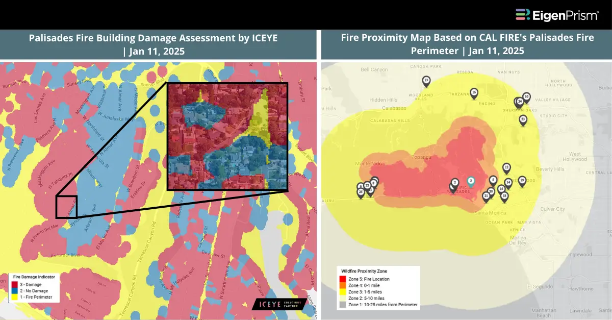
The Palisades Fire has scorched approximately 23,654 acres and is now 11% contained. Over 12,000 structures remain under threat, while officials report that more than 5,300 buildings, including numerous homes, have been damaged or destroyed. In comparison, the Eaton Fire has burned through 14,117 acres in the Altadena and Pasadena areas, with 15% containment as of Saturday. This fire has caused damage to around 7,000 structures.
Meanwhile, the Kenneth Fire, covering 1,052 acres near the Los Angeles-Ventura county border, is now 90% contained. In Sylmar, the Hurst Fire has affected 779 acres, with containment reaching 76% by Saturday morning, leading to the lifting of evacuation orders.
For real-time updates on the spread and containment of the fires, visit CAL FIRE
Actionable Analytics on EigenPrism
Alerts
Users who have alerts set on their exposures for the relevant event sets like those from NIFC and CAL FIRE will receive alerts (if the event footprints impact these exposures).
The CAL FIRE datasets were recently added to EigenPrism. Please note that these datasets are now also available to set alerts.
Set alerts on the CAL FIRE event sets.
Wildfire Perimeter Datasets
All EigenPrism® users can assess the impact on and near the active fire area using the following report template:
California Wildfires Jan 2025 Impact Report Template
This report template enables you to assess the impact of the wildfires based on footprints from CAL FIRE and NIFC. The footprints display active fire zones and their proximity for the Palisades Fire, Eaton Fire, Kenneth Fire, Archer Fire, Hurst Fire, Lidia Fire, and Sunset Fire. The pages auto-update with the latest available data.
Rapid Damage Assessment
ICEYE Building Damage Assessment
Subscribers of ICEYE in EigenPrism can assess the building damage assessment for the Palisades, Eaton, and Hurst fires using the following report template:
California Fires ICEYE Jan 2025 Impact Report Template
Vexcel Aerial Imagery
Subscribers of Vexcel in EigenPrism can access the imagery associated with Palisades and Eaton fires. Subscribers of Vexcel in EigenPrism can use this guided tour to learn more about how to use Vexcel in EigenPrism.
Wind Speed Footprints
Adiabat Daily Peak Wind Gust
All EigenPrism® users can assess the impact of wind using the following footprint:
Daily Peak Wind Gust across North America for Jan 11, 2025
Canopy Weather Peak Wind Gust
Subscribers of Canopy Weather in EigenPrism® can assess the impact of wind using the following footprint:
Daily CONUS Peak Wind Gusts- Prelim 3 as of Jan 11 , 2025
Feel free to contact us at Prism.Support@eigenrisk.com or reach out directly to your Customer Success Manager with any questions or concerns. Our team is here to assist you with setting alerts, understanding report templates, and maximizing the actionable insights available through EigenPrism®.
Jan 11 | Devastating California Wildfires Destroy 12,000 Structures and Cause Billions in Damage
The Palisades Fire, the largest in the region at over 21,000 acres with 8% containment, and the Eaton Fire, which has scorched nearly 14,000 acres with 3% containment, are among California’s top most destructive wildfires ever.
Other fires that ignited in Southern California over the last week include the Kenneth Fire (50% contained, 1,052 acres), the Hurst Fire (70% contained, 771 acres), the Archer Fire (19 acres, 0% contained), and the Lidia Fire (98% contained, 394 acres). Collectively, these fires destroyed thousands of structures, claimed lives, and are projected to cause losses exceeding $135 billion.
For real-time updates on the spread and containment of the fires, visit CAL FIRE
Actionable Analytics on EigenPrism
Alerts
Users who have alerts set on their exposures for the relevant event sets like those from NIFC and CAL FIRE will receive alerts (if the event footprints impact these exposures).
The CAL FIRE datasets were recently added to EigenPrism. Please note that these datasets are now also available to set alerts.
Set alerts on the CAL FIRE event sets.
Wildfire Perimeter Datasets
All EigenPrism® users can assess the impact on and near the active fire area using the following report template:
California Wildfires Jan 2025 Impact Report Template
This report template enables you to assess the impact of the wildfires based on footprints from CAL FIRE and NIFC. The footprints display active fire zones and their proximity for the Palisades Fire, Eaton Fire, Kenneth Fire, Archer Fire, Hurst Fire, Lidia Fire, and Sunset Fire. The pages auto-update with the latest available data.
Rapid Damage Assessment
ICEYE Building Damage Assessment
Subscribers of ICEYE in EigenPrism can assess the building damage assessment for the Palisades, Eaton, and Hurst fires using the following report template:
California Fires ICEYE Jan 2025 Impact Report Template
Vexcel Aerial Imagery
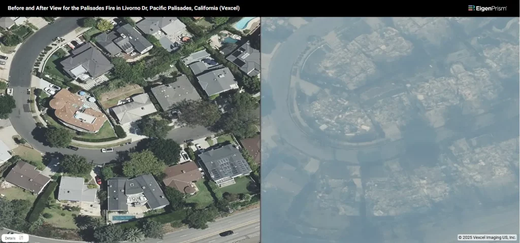
Subscribers of Vexcel in EigenPrism can access the imagery associated with Palisades and Eaton fires. Subscribers of Vexcel in EigenPrism can use this guided tour to learn more about how to use Vexcel in EigenPrism.
Wind Speed Footprints
Adiabat Daily Peak Wind Gust
All EigenPrism® users can assess the impact of wind using the following footprint:
Daily Peak Wind Gust across North America for Jan 10, 2025
Canopy Weather Peak Wind Gust
Subscribers of Canopy Weather in EigenPrism® can assess the impact of wind using the following footprint:
Daily CONUS Peak Wind Gusts- Prelim 3 as of Jan 10 , 2025
Feel free to contact us at Prism.Support@eigenrisk.com or reach out directly to your Customer Success Manager with any questions or concerns. Our team is here to assist you with setting alerts, understanding report templates, and maximizing the actionable insights available through EigenPrism®.
Jan 10 | Raging Wildfires Devastate Southern California: 10 Dead, 29,053 Acres Burned, Over 10,000 Structures Destroyed
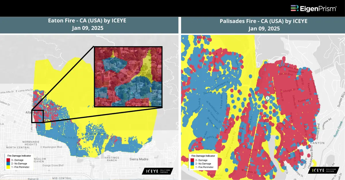 Fierce wildfires burning out of control in the greater Los Angeles area have killed at least 10 people and forced nearly 180,000 more from their homes. Authorities said the total number of deaths is unknown. Dry conditions and powerful winds sparked at least five fires, causing unprecedented scenes in areas not known for fires. Despite the efforts of firefighters, the biggest blazes remain totally uncontained.
Palisades Fire
The Palisades Fire has scorched approximately 19,978 acres and was only 6% contained as of Thursday night. The blaze has destroyed around 5,300 structures, including homes, businesses, and landmarks in Pacific Palisades and areas westward along the Pacific Coast Highway toward Malibu.
Eaton Fire
The Eaton Fire, burning across 13,690 acres, continues to devastate communities in Altadena and Pasadena. Authorities issued additional evacuation orders on Thursday afternoon. This fire is the second-largest in the region and is 0% contained. An estimated 4,000 structures have been damaged or destroyed in its path.
Kenneth Fire
A new wildfire, the Kenneth Fire, ignited near West Hills on Thursday afternoon and quickly spread into Ventura County. The fire erupted near a trailhead along Victory Boulevard and, fanned by powerful winds, consumed 960 acres of brush. The flames are advancing through open terrain and now threaten homes near Malibu Canyon, just north of the 101 Freeway close to Calabasas.
Hurst Fire
Progress has been made in containing the Hurst Fire, which erupted in Sylmar, San Fernando Valley, on Tuesday night. As of Thursday, the fire had burned 771 acres and reached 37% containment. As containment improves, mandatory evacuation orders for the affected areas have been lifted.
Lidia Fire
The Lidia Fire, which broke out Wednesday afternoon in Acton’s Soledad Canyon, has burned 394 acres and is now 75% contained. The fire prompted immediate evacuation orders and warnings after spreading rapidly across hundreds of acres.
Earlier Fires Contained
The Sunset, Woodley, and Olivas Fires, which had previously threatened parts of Southern California, have now been fully contained.
The financial toll of these wildfires is staggering. AccuWeather estimates the overall damage could reach between $52 billion and $57 billion. Insurance analysts at Morningstar DBRS predict insured losses from the Pacific Palisades, Eaton, Hurst, and other Los Angeles-area fires to exceed $8 billion—surpassing the devastation caused by the 2018 Woolsey Fire, which resulted in $6 billion in losses.
To get the current status of the fires as per the California Department of Forestry and Fire Protection, check this link: https://www.fire.ca.gov/Incidents
Actionable Analytics on EigenPrism
CAL FIRE Datasets Now Available for Alert Configuration
We have automated the CAL FIRE feed and integrated the event sets into the Alerts module. You can now configure alerts for these event sets. The feed is scheduled to update every 30 minutes, similar to the NIFC feed.
The available event sets are as follows:
- Fire Perimeters: Active California Wildfires
- Fire Forecast: Proximity Map for Active California Wildfires
Click here to learn more about this.
All EigenPrism® users can assess the impact on and near the active fire area using the following report template:
California Wildfires Jan 2025 Report Template
This report template includes wildfire footprints from CalFire and NIFC, displaying active fire zones and their proximity to surrounding areas. The pages auto-update with the latest available data and cover the following wildfires:
- Palisades Fire
- Eaton Fire
- Kenneth Fire
- Hurst Fire
- Lidia Fire
- Sunset Fire
ICEYE
Subscribers of ICEYE in EigenPrism can assess the impact of Palisades, Eaton, and Hurst Fire area using the following report template:
California Fires ICEYE Jan 2025 Report Template
The report template has the latest available footprints, which include:
- Building Damage Assessment for the Palisades Fire by ICEYE
- Building Damage Assessment for the Eaton Fire by ICEYE
- Building Damage Assessment for the Hurst Fire by ICEYE
Wind
All EigenPrism® users can assess the impact of wind using the following event footprint:
Daily Peak Wind Gust across North America for Jan 09, 2025 from Adiabat
Canopy Weather
Subscribers of Canopy Weather can assess the impact of Winds from Jan 09, 2025 using this footprint within EigenPrism®:
Daily CONUS Peak Wind Gusts- Prelim 3 as of Jan 09, 2025
Jan 09 | Southern California Wildfires: Thousands of Structures Destroyed Amid Hurricane-Force Winds – Latest Report Template Available
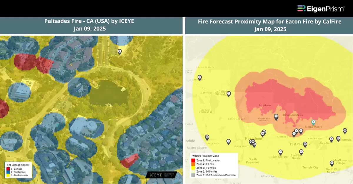
Southern California faces a relentless crisis as devastating fires, driven by hurricane-force winds, wreak havoc across Los Angeles County. According to California Governor Gavin Newsom in an interview with CNN, at least five fatalities have been reported as firefighters continue to battle several wind-fueled blazes that remain primarily uncontained.
Palisades Fire
One of the most destructive is the Palisades Fire, which has engulfed the coastal region between Malibu and Santa Monica. The fire has surged to 17,200 acres with zero containment and has destroyed at least 1,000 structures, marking it as the most catastrophic wildfire in Los Angeles County’s history.
Eaton Fire
The other massive blaze, the rapidly advancing Eaton Fire, continues to devastate the Altadena area, engulfing homes as it spreads across more than 10,000 acres. The wildfire now threatens approximately 13,000 structures, prompting mandatory evacuation orders for Altadena, Pasadena, and Sierra Madre residents.
Hurst Fire
Meanwhile, the Hurst Fire ignited late Tuesday night near Sylmar, north of Los Angeles. Shortly after its emergence, the Los Angeles Fire Department issued evacuation orders, cautioning residents about the fire’s “rapid rate of spread.”
Lidia Fire
The Lidia Fire started later in the day on Wednesday and was 40% contained, according to Cal Fire.
Sunset Fire
The newest fire to break out is the Sunset Fire in the Hollywood Hills, which has prompted evacuation orders for nearby residents. Cal Fire has deployed multiple helicopters and tankers to combat the blaze, with flight tracker data revealing at least six aircraft operating in the area. Aerial operations were impacted on Tuesday night and early Wednesday due to the strong winds.
Powerful winds, dry vegetation, and low humidity have created ideal conditions for rapid fire spread. The NWS predicts wind gusts of 50–80 mph across Southern California into Wednesday night, with mountain and foothill gusts reaching 100 mph, driven by Santa Ana winds.
To get the current status of the fires as per the California Department of Forestry and Fire Protection, check this link: https://www.fire.ca.gov/Incidents
Actionable Analytics on EigenPrism
All EigenPrism® users can assess the impact on and near the active fire area using the following report template:
California Wildfires Jan 2025 Report Template
This report template includes wildfire footprints from CAL FIRE and NIFC, displaying active fire zones and their proximity to surrounding areas. The pages auto-update with the latest available data and cover the following wildfires:
- Palisades Fire
- Eaton Fire
- Hurst Fire
- Lidia Fire
- Sunset Fire
ICEYE
Subscribers of ICEYE in EigenPrism can use the following real-time footprint to quickly assess the impact of wildfire:
Palisades Fire – CA (USA) – as of Jan, 09, 2025
Wind
All EigenPrism® users can assess the impact of wind using the following event footprint:
Daily Peak Wind Gust across North America for Jan 08, 2025 from Adiabat
Canopy Weather
Subscribers of Canopy Weather can assess the impact of Winds from Jan 08, 2025 using this footprint within EigenPrism®:
Daily CONUS Peak Wind Gusts- Prelim 3 as of Jan 08, 2025
Vexcel Aerial Imagery
Vexcel has activated their Gray Sky response for the fires in the LA area. However, given the high winds and the need for the airspace to be clear for firefighting activities, imagery collection has not yet started. They will have their planes in the air as soon as permitted.
Jan 08 | Raging Twin Wildfires Wreak Havoc in California; Palisades and Eaton Fires Trigger Evacuations as Santa Ana Winds Intensify
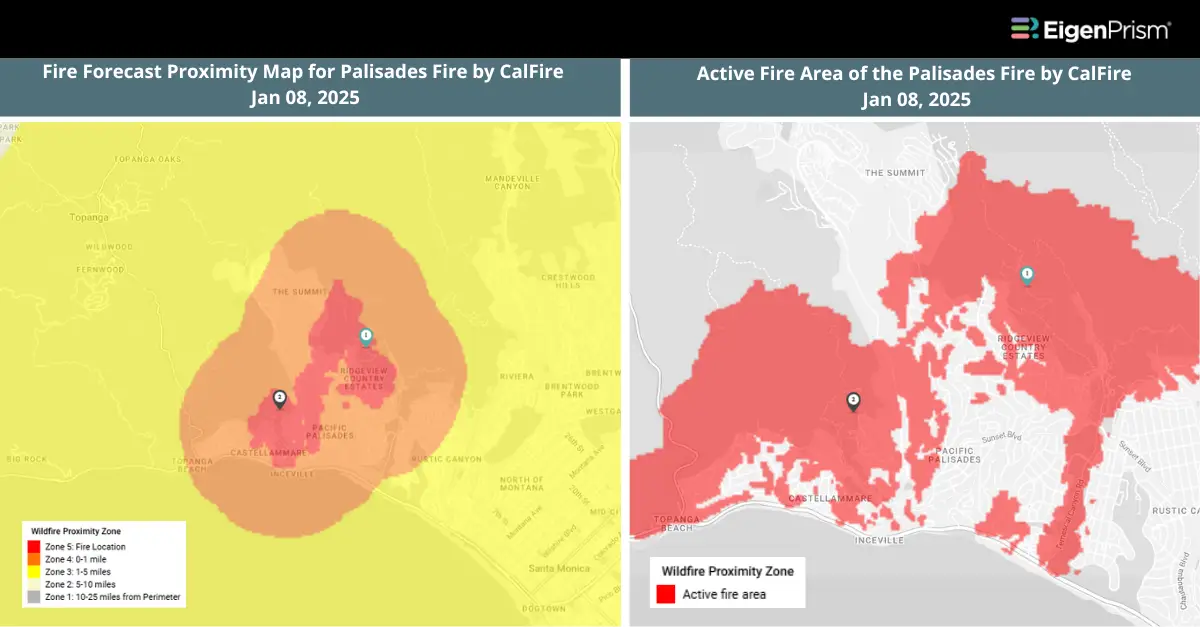 A brush fire quickly intensified into a fierce inferno on Tuesday, propelled by strong winds that pushed the flames toward the Pacific Palisades area. The rapidly spreading Palisades Fire forced the evacuation of at least 30,000 residents from this upscale community. First reported at 10:30 a.m. Pacific Time, on Tuesday, the blaze has expanded to roughly 2,921 acres with 0% containment, according to officials.
The Los Angeles County Fire Department reported that the blaze threatened over 10,300 homes, though the number of damaged or destroyed structures remains unclear. On Tuesday night, Santa Monica issued mandatory evacuation orders for a large city section due to the advancing fire.
Hundreds of firefighters are battling the flames both on the ground in the rugged Santa Monica Mountains, where the fire first started, and from the air, using water and fire retardant drops. The region has been especially vulnerable due to a lack of significant rainfall since last April, leaving dry vegetation that, when combined with strong winds, has raised serious concerns and prompted increased preparations for worsening conditions.
In addition to the Palisades Fire, a second wind-driven blaze erupted in Los Angeles County on Tuesday night. The Eaton Fire, fueled by fierce Santa Ana winds, spread rapidly across 400 acres in the San Gabriel Mountains above Altadena in under two hours. Authorities issued mandatory evacuation orders for several streets in Pasadena and Altadena, warning that the strong winds could accelerate the fire’s spread. Dozens of seniors were evacuated from a Pasadena assisted living facility as the flames drew dangerously close—just one block away.
Meanwhile, more than 200,000 residents across the Los Angeles area were without power late Tuesday due to the intense winds. This figure includes over 34,000 Southern Officials have cautioned that the Santa Ana winds are expected to intensify overnight, with gusts potentially exceeding 100 mph. The National Weather Service issued an urgent warning, describing the situation as “particularly dangerous.”
Palisades and Eaton Fires Trigger Evacuations as Santa Ana Winds Intensify: Actionable Analytics on EigenPrism
All EigenPrism® users can assess the impact on and near the active fire area using the following report template:
California Palisades Fire Jan 2025 Report
- Active Fire Area of the Palisades Fire by CalFire
- Fire Forecast Proximity Map of CA Palisades Fire by CalFire
All EigenPrism® users can also assess the impact on and near the active fire area from Jan 08, 2025, using the following footprint:
- VIIRS Active Fire for US and Hawaii 7-day as of Jan 08 from NASA
Escape the News Cycle | Get Alerts Automatically for Events Impacting Your Assets
With EigenPrism Alerts, you can free yourself from constant event monitoring. Set up personalized alerts based on predefined impact thresholds and choose how you receive them – via email, SMS, or directly within EigenPrism. This way, you can stay informed on your own terms, focusing only on the events that truly matter to your assets.
Set your alerts now.
Don’t have access to EigenPrism®?
Contact us to learn more.[/vc_column_text][/vc_column][/vc_row]