

Tropical Cyclone Jasper Brings Flood Warnings, Queensland Manages Impact
Tropical Cyclone Jasper has been impacting far north Queensland with damaging wind gusts and heavy rainfall. The cyclone, located 125km off Cairns coast, has affected approximately 40,000 homes and businesses due to falling trees and branches.
With no changes in sustained winds near its centre at 95km/hr and gusts up to 130km/hr, Jasper will cross the coast between Hope Vale and Cairns. This has led to flash flooding and destructive winds of up to 140km/hr, particularly in Mossman and the Daintree areas.
Some regions have recorded over 600mm of rain in 24 hours, leading to significant flooding. Flood warnings are in place for several areas, with the Bureau of Meteorology cautioning about the potential for dangerous and life-threatening flash flooding.
The heavy rainfall has also led to road closures, including the Captain Cook Highway between Cairns and Port Douglas. While Jasper has weakened to a category 1 system, there is a possibility that the storm could intensify again in the Gulf of Carpentaria or off the Top End coast early next week.
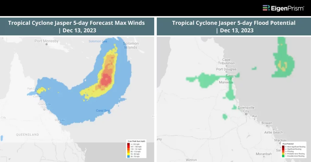
Tropical Cyclone Jasper Brings Flood Warnings: Actionable Insights on EigenPrism
All EigenPrism® users can assess the forecast using the following quick links:
- ANZ 5-day Flood Potential as of 2023-12-13
- ANZ 3-day Flood Potential as of 2023-12-13
- Tropical Cyclone Jasper HindCyc Footprint on 2023-12-15
You can also read about Tropical Cyclone Kirrily, which hit Queensland about a month after Tropical Cyclone Jasper.
December 13 | Tropical Cyclone Jasper Intensifies, Impacting Far North Queensland
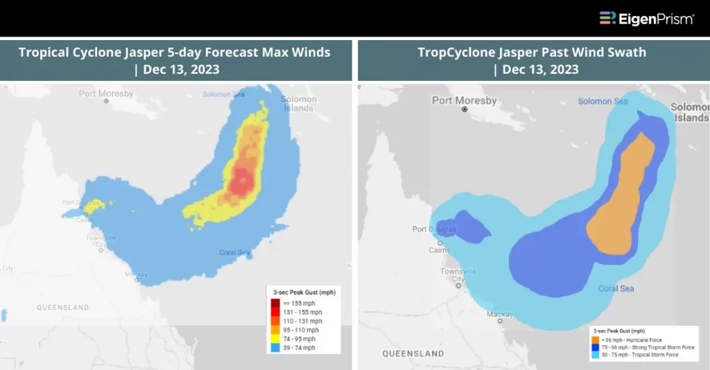
Tropical Cyclone Jasper, having intensified to a category 2, continues to affect far north Queensland with its progression. As of Wednesday, Jasper was positioned 125 km off Cairn’s coast, causing widespread power outages and severe weather conditions, including heavy rain and strong winds.
Currently, Jasper’s sustained winds are at 95km/hr, with gusts reaching up to 130km/hr. The cyclone is anticipated to make landfall between Hope Vale and Cairns, bringing the threat of flash flooding and destructive winds up to 140km/hr. The impact has already been felt with about 15,000 homes losing power, including significant numbers in Cairns and Douglas Shire Council.
Despite its current intensity, Jasper is not expected to escalate to a category 3. However, the risk of flash flooding remains high, with potential rainfall of 250mm to 300mm within six hours, and possibly up to 500mm over 24 hours. However, there is a possibility of the system re-intensifying as it approaches the Gulf by the weekend.
Residents have been advised to prepare for continued severe weather, including potential riverine flooding and storm surges. Jasper is expected to weaken quickly as it moves inland over Cape York Peninsula but may re-intensify as it enters the Gulf at the weekend. This situation remains dynamic, with authorities closely monitoring and responding to the evolving conditions.
Tropical Cyclone Jasper Intensifies: Actionable Insights on EigenPrism
All EigenPrism® users can assess the forecast using the following event footprints:
- Tropical Cyclone Jasper 5-day Forecast Max Winds as of 2023-12-13
- TropCyclone Jasper Forecast Wind Swath as of 2023-12-13
All EigenPrism® users can assess the impact using the following event footprints:
- Tropical Cyclone Jasper Past Max Winds as of 2023-12-13
- TropCyclone Jasper Past Wind Swath as of 2023-12-13
December 12 | Queensland On High Alert As Tropical Cyclone Jasper Approaches
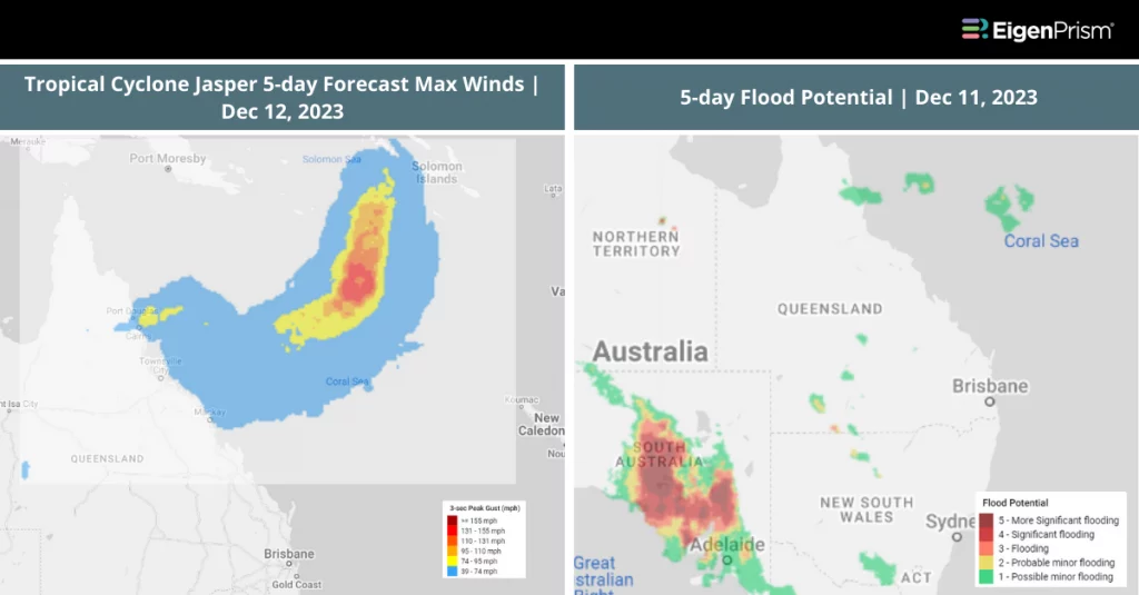
Far north Queensland is gearing up for Tropical Cyclone Jasper, currently a category 1 storm, with expectations of intensifying conditions. Located east of Cairns and northeast of Townsville, Jasper is forecasted to re-intensify to a category 2 as it nears the coast, potentially making landfall between Cape Flattery and Cardwell.
Residents in the path of Jasper, particularly between Cooktown and Ingham, are preparing for damaging winds reaching up to 90km/h from Tuesday. Accompanying these winds, heavy rainfall is expected to develop along the coast, heightening the risk of flooding in the north tropical coast, the Cape York peninsula, and Gulf Country starting Wednesday.
The wind threat may extend to Cape Melville and Townsville. Queensland Fire and Emergency Services have cautioned about the potential impacts of these strong winds, including damage to infrastructure and disruptions to utilities like phone and internet services.
The state’s emergency services are actively monitoring the situation, with residents advised to secure their properties and prepare for potential isolation due to the Tropical Cyclone Jasper. As the cyclone approaches, authorities urge residents to stay informed and adhere to safety guidelines.
Tropical Cyclone Jasper Approaches Queensland: Actionable Insights on EigenPrism
All EigenPrism® users can assess the forecast using the following event footprints:
- Tropical Cyclone Jasper 5-day Forecast Max Winds as of 2023-12-12
- 5-day Flood Potential as of 2023-12-11
- Daily Peak Wind Gust as of 2023-12-11
- TropCyclone Jasper Forecast Wind Swath as of 2023-12-10
Don’t have access to EigenPrism®?
Sign up for a trial account and access full impact reports of all events. Contact us and we’ll set up a trial account for you.






