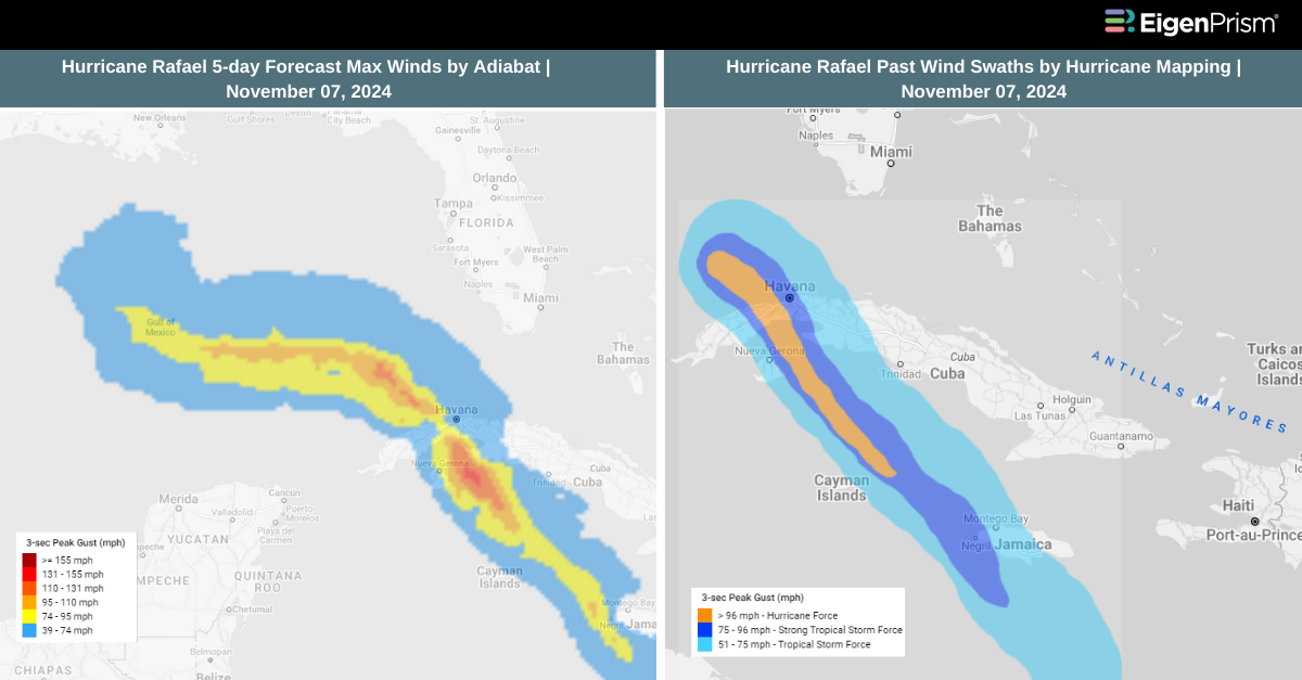
Hurricane Rafael Makes Landfall in Cuba as Category 3, Causing Power Grid Collapse & Widespread Damage
Hurricane Rafael made landfall in Cuba on Wednesday evening as a Category 3 storm before beginning to weaken as it moved toward the southeastern Gulf of Mexico. Despite its diminishing strength, the hurricane continues to batter Cuba with damaging winds, heavy rainfall, and life-threatening storm surges.
As the storm lashed the island, Cuba’s national electrical grid collapsed, plunging 10 million residents into darkness. The national energy company reported that strong winds caused the shutdown of the electricity system. Ahead of Rafael’s arrival, authorities evacuated at least 70,000 people from their homes amid warnings of storm surges, flash flooding, and mudslides.
In the town of Mariel, sustained winds reached 80 mph with peak gusts up to 115 mph as the hurricane’s eye passed nearby. According to the Hurricane Center, a NOAA station at Sand Key in Florida recorded a gust of 66 mph. An additional 2 to 4 inches of rain is expected across western Cuba on Wednesday night, potentially bringing total rainfall accumulations to 12 inches. This heavy rain may lead to flash flooding and mudslides, especially in mountainous regions.
A storm surge of 1 to 3 feet is forecast for the Dry Tortugas National Park area, with 1 to 2 feet predicted in the lower Florida Keys. A Tropical Storm Warning remains in effect for the lower and middle Florida Keys—from Key West to the Channel 5 Bridge—and the Dry Tortugas. Central Cuba is also under a Tropical Storm Warning. The storm is expected to slow down and turn westward on Thursday, maintaining this path through Saturday as it moves across the southern Gulf of Mexico.
Hurricane Rafael Makes Landfall in Cuba as Category 3: Actionable Analytics on EigenPrism
Post-Event
All EigenPrism® users can assess the impact of the tropical storm using the following report template.
Hurricane Rafael 2024 Post-Event Impact Report Template
The report template auto-updates with the latest available footprints, which include
- Hurricane Rafael 2024 Past Max Winds by Adiabat
- Hurricane Rafael 2024 Past Wind Swath – Advisory by Hurricane Mapping
Forecast
All EigenPrism® users can assess the forecast of the tropical storm using the following report template.
Hurricane Rafael 2024 Forecast Impact Report Template
The report template auto-updates with the latest available footprints, which include:
- Hurricane Rafael 2024 5-day Forecast Maximum Winds by Adiabat
- Hurricane Rafael 2024 Forecast Wind Swath by Hurricane Mapping
- Tropical-Storm-Force (greater than 34 kt) Wind Arrival Times by NOAA
- 5-day Tropical-Storm-Force (greater than 34 kt) Wind Probabilities by Hurricane Mapping
- 5-day Hurricane-Force (greater than 64 kt) Wind Probabilities by Wind Hurricane Mapping
- WPC 3-Day Excessive Rainfall Outlook by NWS
- NA 5-day Flood Potential from Adiabat
- US Flood Outlook by NWS
Nov 06 | Rafael Intensifies to Category 1 Hurricane, Brings Severe Weather Threats to Southeastern US
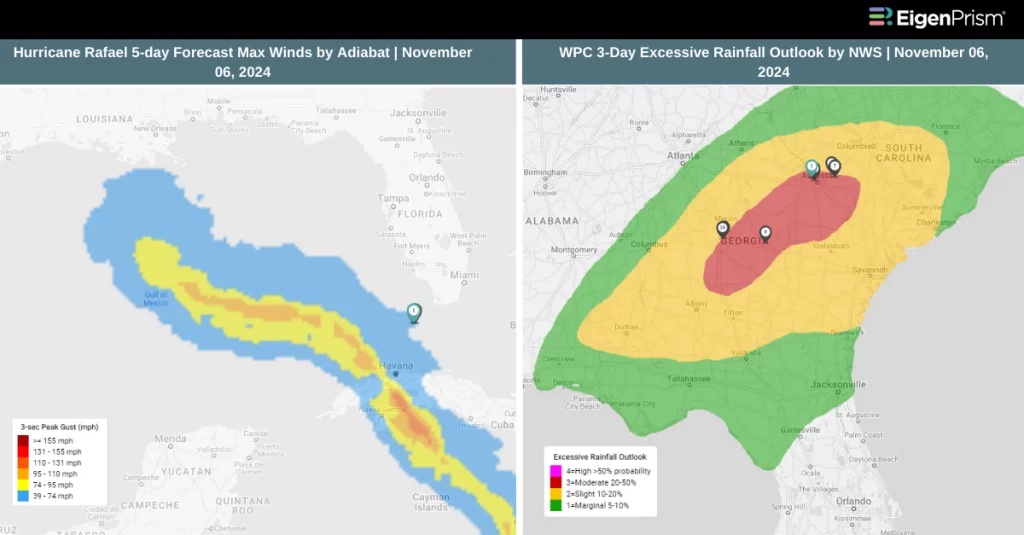 Hurricane Rafael struck the Cayman Islands in the western Caribbean with strong winds and heavy rain. The National Hurricane Center announced that Rafael had intensified into a Category 1 hurricane near the Cayman Islands that evening, with maximum sustained winds increasing from 75 mph to 80 mph in their update.
Forecasters predict that the storm will “rapidly intensify” over the next 12 to 18 hours, potentially reaching Category 2 status—defined by sustained winds of at least 96 mph—before weakening as it makes landfall in Cuba.
A hurricane warning was issued on Tuesday for the Cayman Islands and several Cuban provinces, including Pinar del Rio, Artemisa, Mayabeque, Matanzas, and the Isle of Youth. Havana is also under the warning, which indicates that hurricane conditions such as destructive winds and flooding are expected within 36 hours.
The Cayman Islands can witness damaging winds, torrential rain, storm surges up to 3 feet, and wave heights reaching 15 feet. Federal forecasters warned that a storm surge of 6 to 9 feet along Cuba’s southern coast was possible overnight. Tropical storm conditions were expected in Jamaica on Tuesday afternoon and in the lower and middle Florida Keys on Wednesday.
The storm is anticipated to bring heavy rainfall to the western Caribbean through early Thursday, including 3 to 6 inches across western Cuba. In higher terrain areas of Jamaica and Cuba, isolated totals could reach up to 10 inches, which could lead to flash flooding and mudslides, according to the Hurricane Center.
Heavy rain is then expected to move north into Florida and adjacent areas of the Southeastern US by mid- to late week, with 1 to 3 inches forecasted for the lower and middle Florida Keys. The southwestern corner of Florida, including the Keys, could experience tornadoes starting Wednesday morning and continuing into the afternoon.
Rafael Intensifies to Category 1 Hurricane: Actionable Analytics on EigenPrism
Post-Event
All EigenPrism® users can assess the impact of the tropical storm using the following report template.
Hurricane Rafael 2024 Post-Event Impact Report Template
The report template auto-updates with the latest available footprints, which include
- Hurricane Rafael 2024 Past Max Winds by Adiabat
- Hurricane Rafael 2024 Past Wind Swath – Advisory by Hurricane Mapping
Forecast
All EigenPrism® users can assess the forecast of the tropical storm using the following report template.
Hurricane Rafael 2024 Forecast Impact Report Template
The report template auto-updates with the latest available footprints, which include:
- Hurricane Rafael 2024 5-day Forecast Maximum Winds by Adiabat
- Hurricane Rafael 2024 Forecast Wind Swath by Hurricane Mapping
- Tropical-Storm-Force (greater than 34 kt) Wind Arrival Times by NOAA
- 5-day Tropical-Storm-Force (greater than 34 kt) Wind Probabilities by Hurricane Mapping
- 5-day Hurricane-Force (greater than 64 kt) Wind Probabilities by Wind Hurricane Mapping
- WPC 3-Day Excessive Rainfall Outlook by NWS
- NA 5-day Flood Potential from Adiabat
- US Flood Outlook by NWS
Nov 05 | Tropical Storm Rafael Strengthens in the Caribbean, Set to Become a Hurricane
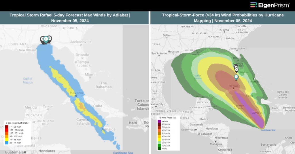 The tropical disturbance in the Caribbean strengthened into Tropical Storm Rafael on Monday afternoon, with forecasters predicting it could reach hurricane status by Tuesday. Rafael is the 17th named storm of this Atlantic hurricane season and is on track to become the 11th hurricane if it continues to intensify.
According to the National Hurricane Center (NHC), Rafael has the potential for rapid intensification as it moves over the warm waters of the northwest Caribbean. The storm is expected to impact Cuba on Wednesday before moving into the Gulf of Mexico.
On Monday afternoon, tropical alerts were extended to include the Florida Keys, adding to existing alerts for Cuba, Jamaica, and the Cayman Islands. Forecasters predict that parts of Florida and nearby southeastern areas could experience heavy rainfall by mid-to-late week. However, the NHC cautioned that it is still too early to determine the specific impacts on the Gulf Coast.
Rafael is expected to bring 3 to 6 inches of rain across much of the western Caribbean, with localized totals reaching up to 9 inches, particularly in Jamaica. Minor coastal flooding is anticipated in Jamaica by Monday evening, while the Cayman Islands could see a storm surge of up to 3 feet on Tuesday. Additionally, flooding and mudslides are possible in areas of Jamaica and Cuba due to the intense rainfall.
Tropical Storm Rafael Strengthens in the Caribbean: Actionable Analytics on EigenPrism
Forecast
All EigenPrism® users can assess the forecast of the tropical storm using the following report template.
Tropical Storm Rafael 2024 Forecast Impact Report Template
The report template auto-updates with the latest available footprints, which include:
- Tropical Storm Rafael 2024 5-day Forecast Maximum Winds by Adiabat
- Tropical Storm Rafael 2024 Forecast Wind Swath by Hurricane Mapping
- Tropical-Storm-Force (greater than 34 kt) Wind Arrival Times by NOAA
- 5-day Tropical-Storm-Force (greater than 34 kt) Wind Probabilities by Hurricane Mapping
- 5-day Hurricane-Force (greater than 64 kt) Wind Probabilities by Wind Hurricane Mapping
- WPC 3-Day Excessive Rainfall Outlook from NWS
- US Flood Outlook from NWS
- NA 5-day Flood Potential from Adiabat
Nov 04 | Potential Tropical Cyclone Eighteen Set to Strengthen into Hurricane, Threatening Cuba and Gulf Coast
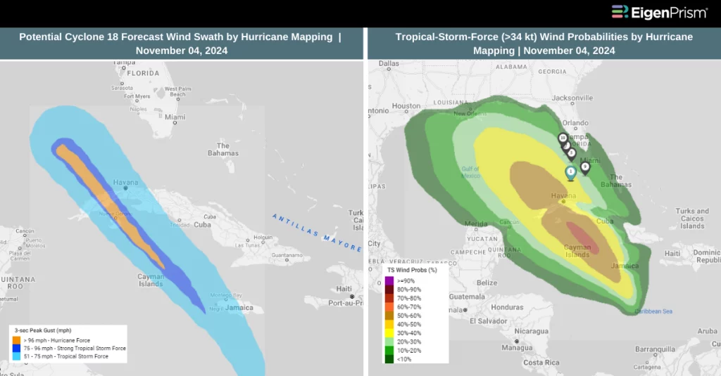 A tropical disturbance in the Caribbean, currently known as Potential Tropical Cyclone Eighteen by the National Hurricane Center (NHC), is likely to strengthen into a hurricane as it moves over Cuba and into the Gulf of Mexico by midweek.
As of 4 a.m. ET update on Monday, the disturbance was located about 260 miles south of Kingston, Jamaica, moving north at a speed of 7 mph with sustained winds of 35 mph. If it intensifies into a tropical storm, it will take the name Rafael, the next on the 2024 Atlantic hurricane list.
The disturbance is expected to reach tropical storm status later today and approach Jamaica by tonight or Tuesday, where a Tropical Storm Warning has been issued. Forecasters anticipate that it could intensify into a hurricane by Tuesday night, posing a serious risk of hurricane-force winds and storm surge in the Cayman Islands and parts of western Cuba.
Even if the system remains a tropical storm, it is forecasted to bring intense rainfall, strong winds, storm surge, and high surf to Jamaica, the Cayman Islands, and southern Cuba over the coming days.
According to the NHC, rainfall totals between 3 to 6 inches, with some areas receiving up to 9 inches, are expected. Flooding is possible across Jamaica and Cuba, with a risk of mudslides in some areas.
Potential Tropical Cyclone Eighteen Set to Strengthen into Hurricane: Actionable Analytics on EigenPrism
Forecast
All EigenPrism® users can assess the forecast of the tropical cyclone using the following report template.
Tropical Cyclone Eighteen 2024 Forecast Impact Report Template
The report template auto-updates with the latest available footprints, which include:
- Tropical Storm Eighteen Forecast Wind Swath – Advisory 03A
- Tropical-Storm-Force (greater than 34 kt) Wind Arrival Times by NOAA
- Tropical-Storm-Force (>34 kt) Wind Probabilities by Hurricane Mapping
- Tropical-Storm-Force (>64 kt) Wind Probabilities by Hurricane Mapping
All EigenPrism® users can assess the forecast of the flooding using the following report template.
US Flood Forecast Report Template
The report template auto-updates with the latest available footprints, which include:
- WPC 3-Day Excessive Rainfall Outlook from NWS
- US Flood Outlook from NWS
- NA 3-day Flood Potential from Adiabat
- NA 5-day Flood Potential from Adiabat
Escape the News Cycle | Get Alerts Automatically for Events Impacting Your Assets
With EigenPrism Alerts, you can free yourself from constant event monitoring. Set up personalized alerts based on predefined impact thresholds and choose how you receive them – via email, SMS, or directly within EigenPrism. This way, you can stay informed on your own terms, focusing only on the events that truly matter to your assets.
Set your alerts now.
Don’t have access to EigenPrism®?
Sign up for a trial account and access full impact reports of all events. Contact us, and we’ll set up a trial account for you.