Millions Evacuated as Typhoon Shanshan Makes Landfall in Southern Japan
Typhoon Shanshan struck southern Japan on Thursday, unleashing record rainfall and powerful winds that killed at least three people, uprooted trees, damaged buildings, and raised concerns of flooding, landslides, and extensive damage.
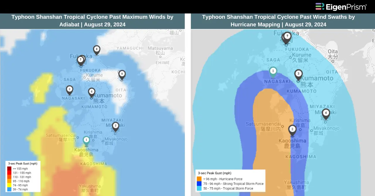
The typhoon made landfall near Satsumasendai in Kagoshima Prefecture, bringing gusts reaching up to 216 kph (134 mph). The intense conditions caused widespread disruption and destruction across the region.
A Level 5 emergency warning, the highest and rarely issued alert was declared on Thursday for the city of Yufu in Oita Prefecture due to severe flooding from the Miyakawa River, which had overflowed its banks under the relentless downpour.
In Miyazaki City, Shanshan’s powerful winds tore through the downtown area, uprooting trees, tossing cars around in parking lots, and shattering windows of several buildings. The prefectural disaster management task force reported damage to 40 buildings.
The storm brought unprecedented rainfall to many areas. Misato, a town in Miyazaki Prefecture, recorded 793 millimeters (31.2 inches) of rain over the past 48 hours, which is approximately 1.4 times its average for the entire month of August. The town of Kinko in Kagoshima Prefecture received 557 millimeters (21.9 inches) of rain, 1.7 times its usual August total, while Saiki in Oita Prefecture saw 537 millimeters (21.1 inches), more than twice its typical monthly average.
By Thursday, over 250,000 households in Kyushu were without power, according to Kyushu Electric. Nearly 220,000 outages were in Kagoshima, with around 16,000 more reported in Miyazaki.
Millions Evacuated as Typhoon Shanshan Makes Landfall in Southern Japan with Severe Weather: Actionable Insights on EigenPrism
Post- Event
All EigenPrism® users can assess the impact of the tropical cyclone using the following report template.
Typhoon Shanshan Post-Event Impact Report
The report template auto-updates with the latest available footprints, which include:
- Typhoon Shanshan 2024 Past Max Winds by Adiabat
- Typhoon Shanshan Past Wind Swath – Advisory by Hurricane Mapping
Forecast
All EigenPrism® users can assess the forecast of the typhoon using the following report template.
Typhoon Shanshan Forecast Impact Report
The report template auto-updates with the latest available footprints, which include:
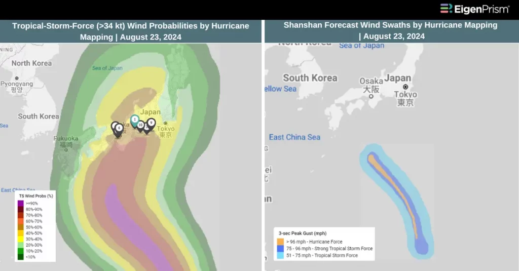
- Typhoon Shanshan Forecast Wind Swath by Hurricane Mapping
- Typhoon Shanshan 2024 5-day Forecast Max Winds by Adiabat
- Tropical-Storm-Force (>34 kt) Wind Probabilities by Hurricane Mapping
- Hurricane-Force (>64 kt) Wind Probabilities by Hurricane Mapping
Aug 23 | Japan Braces for Typhoon Shanshan as It Threatens the Region with Intense Rain, Floods, and Landslides
A tropical depression that initially formed near the Mariana Islands has intensified, becoming Typhoon No. 10, also known as Typhoon Shanshan, by early Thursday morning, August 22.
The Japan Meteorological Agency has warned residents in western Honshu and Shikoku to prepare for intense rainfall and strong winds as Typhoon Shanshan slowly moves west-northwest toward Japan. The storm is projected to gain strength and may reach the southern regions of Japan by Sunday morning. The exact path and timing of the typhoon’s landfall are still uncertain, but there is a considerable chance it could directly impact western Japan by Monday, August 26.
On Friday, Typhoon Shanshan is expected to strengthen further, with maximum sustained winds of about 108 kph and gusts reaching 162 kph. By Sunday afternoon, the storm will likely intensify further, with winds reaching up to 144 kph and gusts as high as 216 kph.
Authorities advise those in the storm’s projected path to brace for severe weather conditions, including strong winds, heavy rainfall, and potential hazards such as lightning strikes, landslides, and flooding. Even areas further east of the storm’s center, not directly in its path, could experience significant adverse weather as Shanshan approaches.
Japan Braces for Typhoon Shanshan as It Threatens the Region with Intense Rain, Floods, and Landslides: Actionable Insights on EigenPrism
Forecast
All EigenPrism® users can assess the forecast of the typhoon using the following report template.
Typhoon Shanshan Forecast Impact Report
The report template auto-updates with the latest available footprints, which include:
- Typhoon Shanshan Forecast Wind Swath by Hurricane Mapping
- Typhoon Shanshan 2024 5-day Forecast Max Winds by Adiabat
- Tropical-Storm-Force (>34 kt) Wind Probabilities by Hurricane Mapping
- Hurricane-Force (>64 kt) Wind Probabilities by Hurricane Mapping
Escape the News Cycle | Get Alerts Automatically For Events Impacting Your Assets
With EigenPrism Alerts, you can set Alerts and free yourself from constant event monitoring. Set up personalized alerts based on predefined impact thresholds and choose how you receive them – via email, SMS, or directly within EigenPrism. This way, you stay informed on your own terms, focusing only on the events that truly matter to your assets.
Set your alerts now.
Don’t have access to EigenPrism®?
Sign up for a trial account and access full impact reports of all events. Contact us, and we’ll set up a trial account for you.