Iowa Ravaged by a Deadly Twister as a Storm Tears Through Des Moines
Millions across Nebraska to Chicago faced the threat of tornadoes on Tuesday, with multiple twisters causing significant damage near Des Moines, Iowa. Over 100 severe storms have been reported from Colorado to Michigan since Monday, indicating a widespread severe weather outbreak. A particularly destructive tornado struck Greenfield, Iowa, southwest of Des Moines, resulting in several fatalities and injuries, as reported by Sgt. Alex Dinkla of the Iowa State Patrol during a Tuesday night news conference.
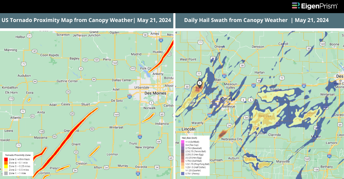
On Thursday, the National Weather Service in Des Moines reported that the tornado striking Greenfield, located approximately 50 miles southwest of Des Moines, reached EF4 intensity. This tornado had peak winds between 175 mph and 185 mph. It stretched over a half-mile in width and traveled a path of 44 miles on the ground.
Tornado watches were issued by the National Weather Service for multiple states, including Nebraska, Iowa, South Dakota, Missouri, Arkansas, Wisconsin, Illinois, Minnesota, Kansas, and Oklahoma, through Tuesday night.
The National Weather Service recorded 20 tornado reports in Iowa and one in Wisconsin on Tuesday. These storms have caused extensive damage, including power outages, structural damage, and flooding. Specific areas like Red Oak, Carbon, Corning, and Greenfield in Iowa reported damages to homes, wind turbines, and power lines. A wind gust reaching 71 mph was seen at the Newton Municipal Airport, east of Des Moines.
On Tuesday, damaging hail was reported from Iowa, Nebraska, and Wisconsin. Golf-ball-sized hail was reported in Mahaska County, Iowa, and tennis-ball-sized hail was reported in Cass County, Nebraska. Additionally, winds exceeding 90 mph were recorded in Dundy County. According to PowerOutage.us, by Tuesday night, power outages had affected nearly 200,000 homes and businesses across Iowa, Wisconsin, and Illinois.
On Wednesday, storms threaten 38 million people from central Texas to upstate New York, with risks including large hail, damaging winds, and possible strong tornadoes. The most severe impacts are expected from central Texas to Missouri. The forecast for Thursday predicts the highest threat of damaging hail and wind will stretch from north Texas across the Ozarks, and tornadoes could occur from Texas to Kentucky. There is also the potential for hail and strong winds throughout the storm-affected regions.
Iowa Ravaged by Deadly Twister as a Storm Tears Through Des Moines: Actionable Insights on EigenPrism
Post- Event
Tornado & Hail
Subscribers of Canopy Weather in EigenPrism can assess the impact of the tornado, hail, and wind from May 21, 2024, using this report template within EigenPrism®
US Tornado, Hail, and Wind From Canopy Weather, May 21, 2024
The report template contains the latest available footprints, which include:
- US Tornado Proximity Map
- Daily Hail Swath Map
- Daily Peak Wind Gusts
All EigenPrism® users can assess the post-event impact of tornado and hail using the following report template:
US Tornado & Hail Post-Event Impact Report
The report template contains the latest available footprints, which include:
- 24-Hr Rotational Track Ending 2024-05-21
- 24-Hr Hail Swath Ending 2024-05-21
Note: Tornado damage survey footprints will be available in Eigen Prism as soon as they are available by NWS
Forecast
All EigenPrism® users can assess the forecast of this multi-peril event using the following report template:
US Severe Weather 2024 Forecast Report
The report template auto-updates with the latest available footprints, which include:
- Significant Tornado Day 1 Outlook
- Significant Hail Day 1 Outlook
- Significant Wind Day 1 Outlook
- WPC 3-Day Excessive Rainfall Outlook
- NA 5-day Flood Potential
- NA 3-day Flood Potential
- US Flood Outlooks
Escape the News Cycle | Get Alerts Automatically For Events Impacting Your Assets
With EigenPrism Alerts, you can set Alerts and free yourself from constant event monitoring. Set up personalized alerts based on predefined impact thresholds and choose how you receive them – via email, SMS, or directly within EigenPrism. This way, you stay informed on your own terms, focusing only on the events that truly matter to your assets.
Set your alerts now.
Don’t have access to EigenPrism®?
Sign up for a trial account and access full impact reports of all events. Contact us, and we’ll set up a trial account for you.