Continued Winter Storm Challenges from Central US to Eastern US
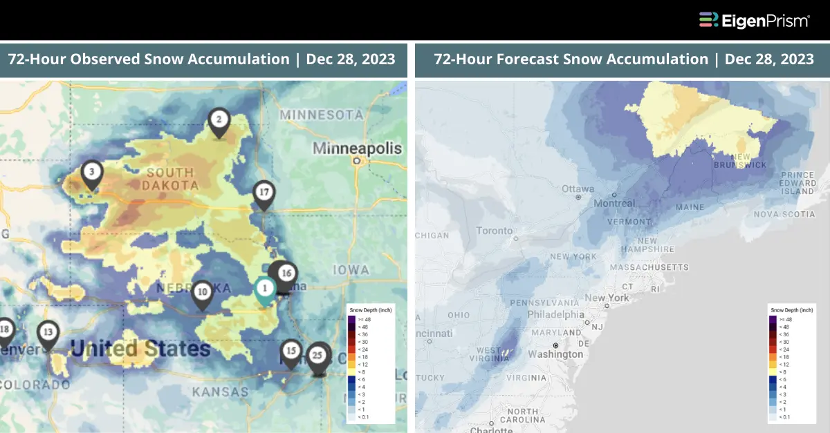
As the Central United States begins to recover from the deadly blizzard that brought heavy snow, freezing rain, and gale-force winds, attention now shifts to the eastern regions, where new weather challenges loom. The aftermath of heavy snow, freezing rain, and gale-force winds continues to be felt, even as a new threat arises in the form of potential flooding.
Cities like Washington, DC, Philadelphia, and New York City are under a Level 1 of 4 flood threat. This may cause travel disruptions due to ponding on roadways and reduced visibility. The legacy of the blizzard that dominated the Plains and upper Midwest remains vivid.
States like Nebraska, South Dakota, Kansas, Colorado, and Wyoming experienced severe conditions, with snow combining with wind gusts of up to 75 mph to create dangerous blizzards. The National Weather Service reported significant snowfall in parts of South Dakota, with Gregory receiving 13.8 inches, and both Deadwood and Spearfish getting 12 inches of snow.
Additionally, Aurora in Colorado saw 7.5 inches, while Norfolk in Nebraska experienced 7 inches of snow accumulation. The weather forecast indicates a gradual easing of conditions. Light-to-moderate snow, along with rain and freezing rain, is expected in parts of the affected region, but should largely subside by Thursday night.
Continued Winter Storm Challenges Across Central US To Eastern US: Actionable Insights on EigenPrism
All EigenPrism® users can assess the impact of the snowfall using the following event footprints:
- 72-hour observed snow accumulation as of 2023-12-28
All EigenPrism® users can assess the forecast using the following event footprints:
- 72-Hr Forecast Freezing Rain Accumulation (90th Percentile) as of 2023-12-28
- 72-Hr Forecast Snow Accumulation (90th Percentile) as of 2023-12-28
- US Flood Outlook as of 2023-12-28
- WPC 3-Day Excessive Rainfall Outlook as of 2023-12-27
- 1-3 Day Potential Winter Storm Overall Impact as of 2023-12-27
- Daily Peak Wind Gust across North America as of 2023-12-27
Dec 28 | Harsh Winter Storm Strikes Central US with Gale Force Winds and Snow
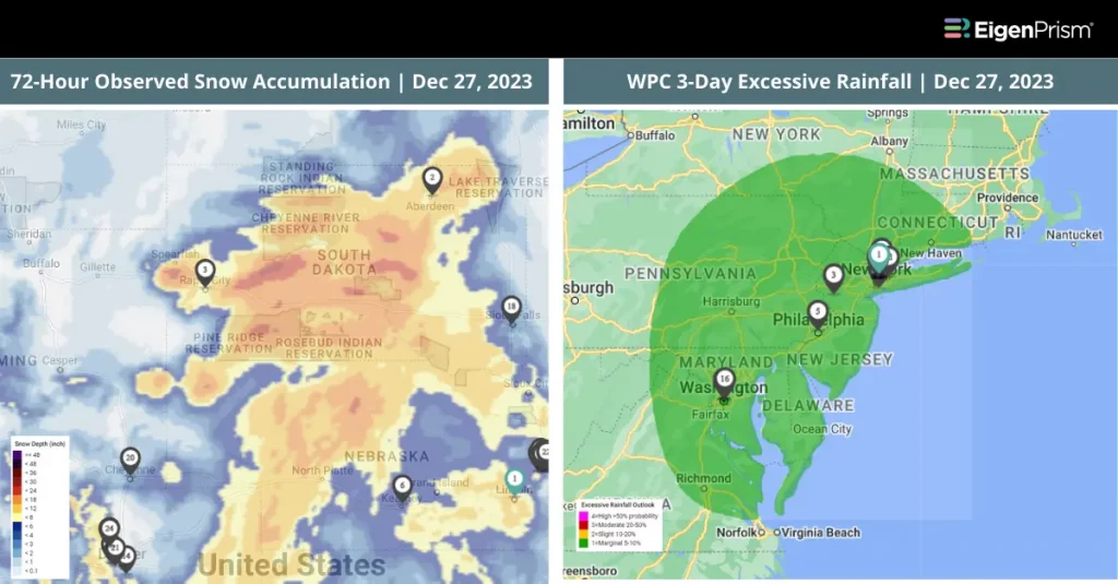
A powerful winter storm has unleashed its fury across the central United States, marking a period of heightened concern and disruption. The storm’s wrath peaked with wind gusts of 50 to 60 mph, occasionally hitting a staggering 75 mph, creating whiteout conditions on Monday and Tuesday.
This storm has brought a harsh combination of snow, ice, and gale-force winds, causing widespread distress and challenging emergency response efforts. Visibility dropped to a perilous quarter-mile or less, making travel near impossible in parts of Nebraska, South Dakota, Kansas, Colorado, and Wyoming, where blizzard warnings were declared.
The heavy snowfall and ice accumulation have raised alarms over potential power outages and structural risks. South Dakota bore the brunt of the snowfall, with regions receiving over a foot of snow. Meanwhile, Aurora, Colorado, and Norfolk, Nebraska, were blanketed under several inches.
As the storm gradually recedes, the focus now shifts to recovery and assessing the full extent of its impact. On Wednesday, the weather across various regions will improve. The Midwest will see an end to its snowfall, while the freezing rain over the Northern Plains should also cease.
Additionally, the Appalachian Mountains are likely to experience a reduction in heavy rainfall. However, there’s a slight risk of excessive rainfall along the I-95 corridor in the northern Mid-Atlantic and Northeast, potentially affecting major cities in flood threats like Washington, DC, Philadelphia, and New York City, which might lead to travel delays.
Harsh Winter Storm Strikes Central US: Actionable Insights on EigenPrism
All EigenPrism® users can assess the impact of the snowfall using the following event footprints:
- 72-hour observed snow accumulation as of 2023-12-27
All EigenPrism® users can assess the forecast using the following event footprints:
- 72-Hr Forecast Freezing Rain Accumulation (90th Percentile) as of 2023-12-27
- 72-Hr Forecast Snow Accumulation (90th Percentile) as of 2023-12-27
- 1-3 Day Potential Winter Storm Overall Impact as of 2023-12-27
- WPC 3-Day Excessive Rainfall Outlook as of 2023-12-27
- Daily Peak Wind Gust across North America as 2023-12-26
Don’t have access to EigenPrism®?
Sign up for a trial account and access full impact reports of all events. Contact us and we’ll set up a trial account for you.