Winds and Torrential Rains Trigger Severe Flooding and Widespread Damage in Houston
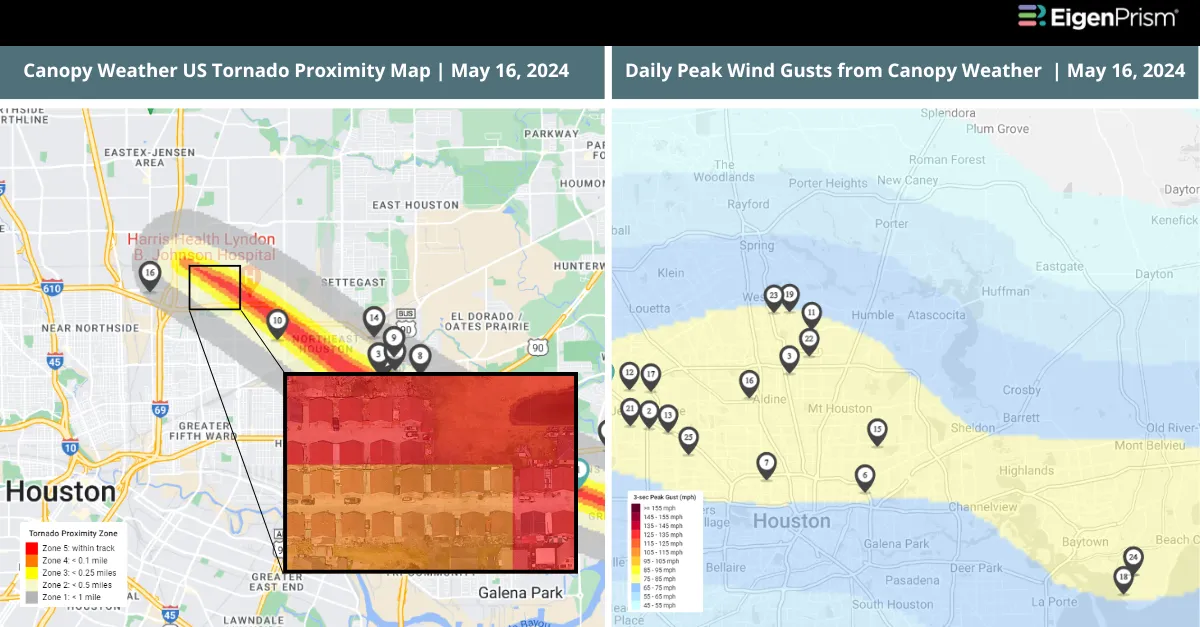
A powerful storm system looming over East Texas unleashed severe thunderstorms in Houston, on Thursday. The storm resulted in at least four deaths and left over a million without electricity. Wind speeds surpassing 70 mph caused extensive damage, including toppling trees, shattering high-rise building windows, and bringing down power line towers.
The violent storm partially collapsed a nightclub, and tore a section of roofing from the Hyatt Regency downtown, resulting in rain and debris falling into the hotel lobby, according to a video posted on social media. Further damage was seen with blown-out windows in several downtown buildings, including the Wells Fargo Plaza.
The storms left nearly one million homes and businesses across Texas without power, and Louisiana also reported significant outages affecting over 100,000 due to the adverse weather. The National Weather Service forecasted 3 to 6 inches of rainfall, possibly more in some areas, and a flood watch was in place until Friday morning.
“Downtown is a mess and dangerous,” stated Houston Mayor John Whitmire. Fallen trees are obstructing roads, and many traffic lights are out of service. Initially, it was uncertain whether the damage in Houston was caused by a tornado or straight-line winds, but it was later confirmed that a twister had struck Jacinto City.
Forecasters had anticipated severe storms for Texas and Louisiana, focusing on flood risks. The National Weather Service issued warnings for “destructive winds” of at least 80 mph and placed a tornado watch for southeast Louisiana, including New Orleans. The Storm Prediction Center reported over 40 instances of damaging winds across Texas.
The National Weather Service in Houston also warned of the potential for tornadoes as severe storms continued to move across coastal counties. It forecasted a few tornadoes and isolated instances of hail up to 2 inches in diameter. In Louisiana, a tornado was spotted in Welcome ( an unincorporated community in St. James Parish, Louisiana) near New Orleans, where a tornado watch is in place until Friday evening.
Winds and Torrential Rains Trigger Severe Flooding and Widespread Damage in Houston: Actionable Insights on EigenPrism
Post- Event
Tornado, Hail, & Wind
Subscribers of Canopy Weather in EigenPrism can assess the impact of the tornado, hail, and wind from May 16, 2024, using these footprints within EigenPrism®
US Tornado, Hail, and Wind From Canopy Weather, May 16, 2024
The report template contains the latest available footprints, which include:
- US Tornado Proximity Map
- Daily Hail Swath Map
- Daily Peak Wind Gusts
All EigenPrism® users can assess the post-event impact of tornado and hail using the following report template:
US Tornado & Hail for May 16 Post-Event Impact
The report template contains the latest available footprints, which include:
- 24-Hr Rotational Track Ending 2024-05-16
- 24-Hr Hail Swath Ending 2024-05-16
Forecast
All EigenPrism® users can assess the forecast of this multi-peril event using the following report template:
US Severe Weather 2024 Forecast Report
The report template auto-updates with the latest available footprints, which include:
- Significant Tornado Day 1 Outlook
- Significant Hail Day 1 Outlook
- Significant Wind Day 1 Outlook
- WPC 3-Day Excessive Rainfall Outlook
- NA 5-day Flood Potential
- NA 3-day Flood Potential
- US Flood Outlooks
May 16 | Severe Weather and Persistent Rainfall Brings Flash Flood in East Texas and Louisiana
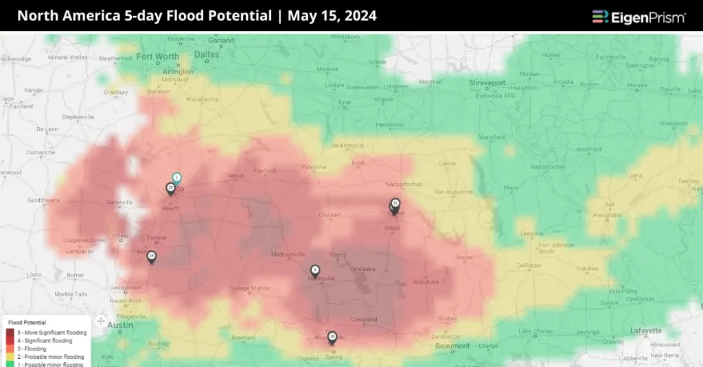 Much of the South is currently facing a critical situation with persistent showers and potentially severe thunderstorms expected to affect East Texas until at least Saturday. Some areas, already soaked with 12-20 inches of rain in recent weeks, may see an additional half-foot of rainfall.
Communities north of Houston are watching for an increased flood threat on Thursday and Friday. Some areas were already reporting a yearly surplus of a foot before the most recent round of rainfall.
NOAA’s Weather Prediction Centre’s latest discussion emphasizes the severity of the situation, calling it a “nightmare scenario” for the southern Plains and Lower Mississippi Valley. It has raised concerns about potential flash flooding across three states, with an anticipated 6 inches or more of rainfall. This has led to a Level 3 out of 4 risk for flash flooding. Additionally, local National Weather Service offices have issued Flood Watches for over 10 million residents in these states, effective from Thursday into early Friday morning.
The ground in the Piney Woods and western Louisiana is already saturated from recent rainfall, leading rivers and streams to swell to levels not seen since Hurricane Harvey in 2017. Any further rain could result in significant flooding.
Severe Weather and Persistent Rainfall Brings Flash Flood in East Texas and Louisiana: Actionable Insights on EigenPrism
Forecast
All EigenPrism® users can assess the forecast of this multi-peril event using the following report template:
US Severe Weather 2024 Forecast Report
The report template auto-updates with the latest available footprints, which include:
- Significant Tornado Day 1 Outlook
- Significant Hail Day 1 Outlook
- Significant Wind Day 1 Outlook
- WPC 3-Day Excessive Rainfall Outlook
- NA 5-day Flood Potential
- NA 3-day Flood Potential
- US Flood Outlook
May 15 | Severe Weather Across the Southeast Brings Hurricane-Force Winds and Flood Risks
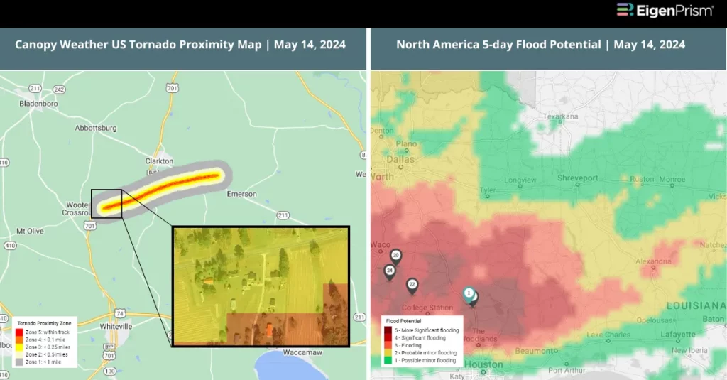
Powerful hurricane-strength winds and a likely tornado struck Louisiana, resulting in three fatalities. A small tornado was spotted in Clarkton, North Carolina. The Southern region is bracing for more severe weather, with heightened risks of flash floods, destructive winds, and hail continuing through Saturday.
The National Weather Service (NWS) warned that the severe weather threat might not be over by Tuesday. There is still the possibility of damaging winds, large hailstones across the Gulf Coast and the Southeast, and possible tornadoes in central and southern Florida and southern Georgia.
The NWS issued a tornado warning for North Carolina on Tuesday, covering Fayetteville, among other areas. Heavy rainfall affected Wake County and neighboring counties, leading to accidents and significant traffic delays for hours in Cumberland County. Near Whiteville, a tornado damaged properties, blowing out windows, collapsing roofs, and knocking down several trees.
On Monday, eastern Texas and Florida experienced powerful winds, hail, and tornadoes. By Tuesday, northern Florida was dealing with the most severe threat of thunderstorms and heavy rainfall, witnessing damaging winds, hail, and rainfall of 3 to 5 inches, with a tornado reported. On Wednesday, Victoria, Texas, 30 miles from the Gulf of Mexico, faced hailstorms with hail as large as golf balls and frequent lightning strikes.
The NOAA’s Weather Prediction Center has issued a Level 3 out of 4 alert for flash flooding in three states. In Texas, state and federal officials are assessing the damage after recent flooding, which has damaged and destroyed hundreds of homes. The biggest concerns are upcoming rounds of heavy rain on Thursday and Friday, particularly in areas between Interstates 10 and 20.
River levels, such as that of the Trinity River in northeast Houston, remain high from prior rains and are still in a major flood stage. On Tuesday, over 100,000 homes and businesses were without power across Texas and Florida, with Louisiana experiencing the most severe outages, over 58,000, according to PowerOutage.us.
Severe Weather Across the Southeast Brings Hurricane-Force Winds and Flood Risks: Actionable Insights on EigenPrism
Post- Event
Tornado & Hail
Subscribers of Canopy Weather in EigenPrism can assess the impact of the tornadoes and hail for May 14, 2024, using this report template within EigenPrism®
US Tornadoes & Hail from Canopy Weather, May 14, 2024
Forecast
All EigenPrism® users can assess the forecast of this multi-peril event using the following report template:
US Severe Weather 2024 Forecast Report
The report template auto-updates with the latest available footprints, which include:
- Significant Tornado Day 1 Outlook
- Significant Hail Day 1 Outlook
- Significant Wind Day 1 Outlook
- WPC 3-Day Excessive Rainfall Outlook
- NA 5-day Flood Potential
- NA 3-day Flood Potential
- US Flood Outlook
May 14 | Florida Faces Devastating Severe Weather as Tornadoes, Winds, and Hail Strike the Gulf Coast
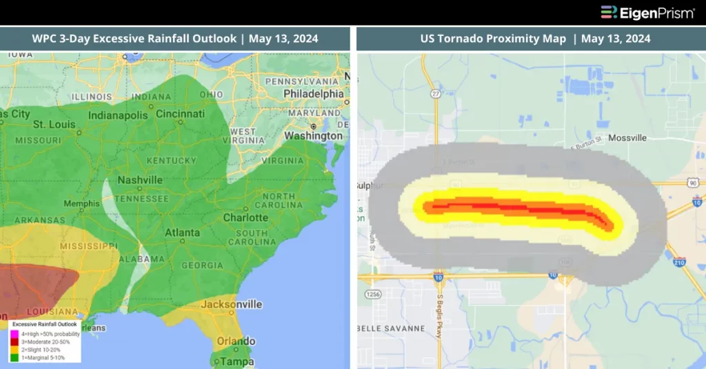 The week started with intense thunderstorms that swept through the Gulf Coast, bringing substantial hail, strong winds, heavy rainfall, and at least one confirmed tornado. Last week, severe weather had wreaked havoc across the South. Now, these storms impacted areas from Texas to Florida, hitting particularly hard along and South of the Interstate 10 corridor. Flooding has become a significant concern, particularly in southeastern Texas, which is grappling with the aftermath of prolonged heavy rainfall.
On Monday afternoon, hailstones as large as golf balls were reported in Victoria, Texas. Florida also experienced similar-sized hail in several locations. The storms have caused widespread damage, including fallen trees and power lines, resulting in over 80,000 power outages across various Gulf Coast states. By early Tuesday, power outages had affected over 140,000 homes and businesses in Texas, Louisiana, and Florida, with Louisiana experiencing most of these disruptions. One of the strongest wind gusts recorded was 82 mph in Milton, Florida, comparable to winds from a Category 1 hurricane.
Additionally, waterspouts formed along the Florida Panhandle coast, with at least one transitioning into a tornado near Santa Rosa Beach. Fortunately, it caused no significant damage. Reports also indicate a tornado may have been responsible for substantial destruction in Lake Charles, Louisiana, including damage at a local Walmart, residential structural issues, and an overturned tractor-trailer on I-10.
Over 9 million people are under flood watches across a region spanning from Central Texas to southeast Georgia, including areas near Houston already impacted by recent storms. Major cities like New Orleans, Shreveport, Mobile, and Tallahassee are at risk of flooding.
This series of severe weather events continues challenging the South, with repeated rain and thunderstorms over the past week. Just on Sunday, another round of severe weather brought tennis ball-sized hail through Texas into Louisiana, prompting the issuance of tornado watches and flash flood warnings.
According to NWS heaviest rainfall, potentially up to 3 inches per hour, to occur from southeastern Louisiana to western Florida, leading to a cumulative rainfall of up to 8 inches. The focus of the severe weather will shift southeast from Tuesday, with the Florida Panhandle to the Carolinas likely to experience the majority of the storms.
Florida Faces Devastating Severe Weather as Tornadoes, Winds, and Hail Strike the Gulf Coast: Actionable Insights on EigenPrism
Tornado & Hail
Subscribers of Canopy Weather in EigenPrism can assess the impact of the tornadoes and hail from May 13, 2024, using these footprints within EigenPrism®
US Tornado Proximity Map as of 2024-05-13
Daily CONUS Hail Swath Map – as of 2024-05-13
All EigenPrism® users can assess the post-event impact of tornadoes and hail using these following report template:
US Tornadoes (EF2+) May 11-13, 2024 Post-Event Impact
The report template contains the latest available footprints, which include:
- EF3 Tornado Track in Mossville
- EF2 Tornado Track in Henderson
- EF2 Tornado Track in Tallahassee
- EF2 Tornado Track in Ochlockonee
US Hail May 11-14, 2024, Post-Event Impact
The report template contains the latest available footprints, which include:
- 24-Hr Hail Swath ending 2024-05-14
- 24-Hr Hail Swath ending 2024-05-13
- 24-Hr Hail Swath ending 2024-05-12
- 24-Hr Hail Swath ending 2024-05-11
Forecast
All EigenPrism® users can assess the forecast of this multi-peril event using the following report template:
US Severe Weather April Forecast Report
The report template auto-updates with the latest available footprints, which include:
- Significant Tornado Day 1 Outlook
- Significant Hail Day 1 Outlook
- Significant Wind Day 1 Outlook
- WPC 3-Day Excessive Rainfall Outlook
- NA 5-day Flood Potential
- NA 3-day Flood Potential
Escape the News Cycle | Get Alerts Automatically For Events Impacting Your Assets
With EigenPrism Alerts, you can set Alerts and free yourself from constant event monitoring. Set up personalized alerts based on predefined impact thresholds and choose how you receive them – via email, SMS, or directly within EigenPrism. This way, you stay informed on your own terms, focusing only on the events that truly matter to your assets.
Set your alerts now.
Don’t have access to EigenPrism®?
Sign up for a trial account and access full impact reports of all events. Contact us, and we’ll set up a trial account for you.