Cyclone Ilsa Hits Western Australia Coast with Record-Breaking Winds: Assess the Impact
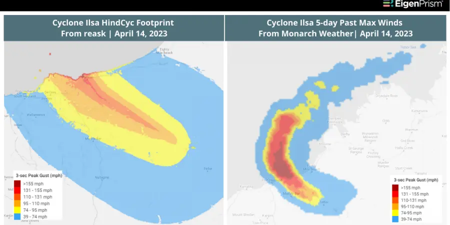
Around midnight on Thursday, Cyclone Ilsa made landfall as a Category 5 storm on a remote stretch of Western Australian coastline between De Grey and Pardoo Roadhouse. The storm shattered previous wind speed records set more than ten years earlier, with sustained winds of 75 miles per hour.
The storm has since weakened, bringing heavy rain as it moves southeast across the state. Although the main population centers were spared, the Pardoo Roadhouse, a local tavern and caravan park, suffered significant damage. The storm has been downgraded to a Category 3, but some inland communities are still under a red alert.
Actionable Insights on EigenPrism
To make timely decisions about this event, EigenPrism® users can assess the impact of the event using the following quick links:
- TropCyclone Ilsa Past Wind Swath – Advisory 21 as of 2023-04-13 – v3 | v4
- Tropical Cyclone Ilsa 2023 Past Max Winds as of 2023-04-14 – v3 | v4
- Daily Peak Wind Gust across ANZ as of 2023-04-13 – v3 | v4
For subscribers of reask, real-time footprints within EigenPrism® are now available for analysis:
April 13, 2023 | Cyclone Ilsa, Likely to Become Category 5 Storm Before Striking Western Australia: Get Actionable Insights
Cyclone Ilsa is projected to strengthen to a Category 5 storm and is likely to make landfall between Port Hedland and Wallal Downson on Thursday evening or Friday morning, with wind gusts of 177 miles per hour. Port Hedland is somewhat sparsely inhabited with a population of 16,000 and is the largest town in the route of the storm.
Isla is currently a Category 4 storm, located north of Port Hedland. Hours before the cyclone’s predicted landfall, strong winds are already affecting coastal areas, and emergency services are urging people to secure anything that may become airborne.
Additionally, Cyclone Ilsa is anticipated to bring heavy rainfall to the region, with estimates of up to 200 to 300 millimeters.
Actionable Insights on EigenPrism
To make timely decisions about this event, EigenPrism® users can assess the impact of the event using the following quick links:
- TropCyclone Ilsa Forecast Wind Swath – Advisory 19 as of 2023-04-13 – v3 | v4
- Tropical Cyclone Ilsa 2023 5-day Forecast Max Winds as of 2023-04-13 – v3 | v4
April 12, 2023 | Cyclone Ilsa, Western Australia Braces as Category 4 Storm Approaches Rapidly: Get Actionable Insights
Cyclone Ilsa is intensifying into a Category 4 storm and heading towards Western Australia. It is expected to make landfall on Thursday and could cause substantial property damage as well as extensive power cuts.
Cyclone Ilsa is presently a Category 3 storm with wind gusts of up to 165km/h and is situated around 370km northwest of Broome. Nevertheless, by the time it reaches landfall between Broome and Port Hedland, it is predicted to have strengthened into a Category 4 storm, with gusts of up to 270km/h. This will be the first time in over a decade that the region will be hit by a storm of such magnitude.
As a precaution, the Bureau of Meteorology has issued evacuation orders for remote Aboriginal communities, mines, pastoral stations, and tourism businesses. Residents in buildings not built to withstand a Category 4 weather event have also been encouraged to follow these orders.
Cyclone Ilsa is expected to weaken and downgrade to a tropical low by early Saturday.
Actionable Insights on EigenPrism
To make timely decisions about this event, EigenPrism® users can assess the impact of the event using the following quick links:
- TropCyclone Ilsa Forecast Wind Swath – Advisory 15 as of 2023-04-12 – v3 | v4
- Tropical Cyclone Ilsa 2023 5-day Forecast Max Winds as of 2023-04-12 – v3 | v4
Don’t have access to EigenPrism?
Sign up for a trial account and access full impact reports of all events. Contact us and we’ll set up a trial account for you.