Levee Failures and Renewed Flooding Escalate Risks Across Washington
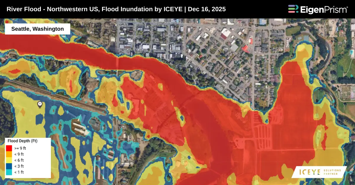
Atmospheric river storms continue to impact Washington state, placing severe strain on flood control infrastructure and transportation networks. Multiple levee failures have been reported, more than a dozen highways remain closed, and authorities have confirmed one fatality linked to the ongoing flooding.
Flooding and landslides have also caused widespread transportation disruptions. As of Tuesday morning, road damage has forced closures on more than a dozen highways across nine counties, limiting access for residents and emergency responders.
In Pacific, Washington, precautionary evacuation orders were issued Tuesday morning for approximately 1,300 residents following a levee breach along the White River. Prolonged heavy rainfall and record-level flooding from last week’s atmospheric river event have left soils saturated and river systems already elevated across western Washington. As a result, several rivers that had begun to recede are now rising again, renewing flood concerns.
Actionable Analytics on EigenPrism
Post Event
ICEYE Flood Dataset
Subscribers of ICEYE in EigenPrism can assess the impact of flood inundation, using the following event footprints:
KatRisk Flood Dataset
Subscribers of Katrisk on EigenPrism can use this footprint to quickly assess the impact of the flood inundation:
Forecast
Flood Dataset
All EigenPrism® users can assess the forecast of the flood using the following report template:
This report template consists of the following flood footprints: WPC 3-Day Excessive Rainfall Outlook & US Flood outlook by NWS and 3-day & 5-day flood potential from Adiabat. The pages auto-update with the latest available data.
Alerts
Users who have alerts set on their exposures for the relevant event sets, like those from NWS and Adiabat, will receive alerts (if the event footprints impact these exposures).
To learn more about how to set an alert on a specific event set, check out this help center article.
Feel free to contact us at Prism.Support@eigenrisk.com or reach out directly to your Customer Success Manager with any questions or concerns. Our team is here to assist you with setting alerts, understanding report templates, and maximizing the actionable insights available through EigenPrism®.
Dec 10 | Atmospheric River Drives Widespread Flooding Risk Across the Pacific Northwest
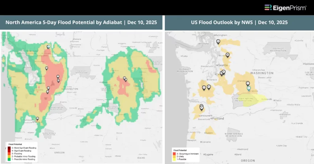
A powerful series of storms driven by an intense atmospheric river system is battering the Pacific Northwest, bringing torrential rainfall, rapidly rising rivers, widespread road closures, and multiple high-water rescues across Washington and Oregon.
The Skagit River near Concrete in Skagit County (north of Seattle) is forecast to crest above 47 feet, exceeding the previous record and major flood threshold. The Snohomish River in Snohomish County near Everett is expected to rise to 33.6 feet within 48 hours, nearly 12 feet above normal, breaking its historic record.
In Oregon, heavy rainfall has triggered urban and river flooding across the Willamette Valley and northwest counties, including parts of the Portland metro area, where storm drains and low-lying roads have been overwhelmed.
Flood watches remain in effect across western Washington through Friday, with additional watches issued for parts of Oregon, Idaho, and western Montana as the atmospheric river continues to bring prolonged rainfall.
Actionable Analytics on EigenPrism
Forecast
Flood Dataset
All EigenPrism® users can assess the forecast of the flood using the following report template:
This report template consists of the following flood footprints: WPC 3-Day Excessive Rainfall Outlook & US Flood outlook by NWS and 3-day & 5-day flood potential from Adiabat. The pages auto-update with the latest available data.
Post-Event
ICEYE Flood Dataset
Subscribers of ICEYE in EigenPrism can assess the impact of flood inundation, using the following event footprints:
Alerts
Users who have alerts set on their exposures for the relevant event sets, like those from NWS and Adiabat, will receive alerts (if the event footprints impact these exposures).
To learn more about how to set an alert on a specific event set, check out this help center article.
Feel free to contact us at Prism.Support@eigenrisk.com or reach out directly to your Customer Success Manager with any questions or concerns. Our team is here to assist you with setting alerts, understanding report templates, and maximizing the actionable insights available through EigenPrism®.
Not an EigenPrism User? Here’s a Quick Way to Check ZIP-Level Impact
For underwriters, brokers, and portfolio managers who need fast visibility into impacted ZIP codes, we’ve built a tool called ZIP Response on our website. It’s a free, no-login tool that highlights the top ZIP codes that are most impacted during active events, such as hurricanes, floods, wildfires, and severe storms.
You can request the complete ZIP list by simply filling out a short form and get it delivered straight to your inbox.
If you’d like to explore the impacted ZIP codes for this event, visit ZIP Response.
Or Contact us, to have more info on this.
Download the EigenAlert Mobile App Today!
With the EigenAlert mobile app, monitor alerts and impacted assets without being tied to your desk.

How to Get Started:
- Scan the QR code using your phone to download the app.
- Log in with your existing EigenPrism credentials.
- Begin accessing your alerts instantly.