Jamaica on High Alert as Hurricane Melissa Reaches Category 5 Strength
As per the latest update from NHC as of Tuesday, 11:00 am EDT
Hurricane Melissa is now Category 5 Storm. Melissa is producing maximum sustained winds of 185 mph (295 km/h), moving north-northeast at 9 mph. The eyewall of Hurricane Melissa has reached Jamaica’s coastline, with landfall expected within the next few hours near Crawford in the island’s southwest region. Powerful outer bands are already battering the area with intense winds and heavy rainfall. Authorities have issued mandatory evacuation orders for vulnerable coastal zones as the storm intensifies. According to the National Hurricane Center, Melissa could bring up to 40 inches of rain, storm surges reaching 13 feet, and sustained winds of 160 mph — conditions likely to cause extensive infrastructure damage and isolate several communities across Jamaica.
Oct 27 | Hurricane Melissa Intensifies to Category 4, Threatens Jamaica and Cuba
Hurricane Melissa has intensified into a powerful Category 4 storm as it moves toward Jamaica and Cuba, bringing the threat of devastating floods, landslides, and storm surges across the Caribbean. The hurricane is currently packing maximum sustained winds of around 150 mph (240 km/h) and is expected to strengthen further, potentially reaching Category 5 intensity within the next 24 hours.
Forecasts indicate that Melissa will make landfall in Jamaica late Monday night or early Tuesday morning, then continue on its path toward southeastern Cuba later Tuesday. Torrential rains will pound Jamaica, Haiti, and the Dominican Republic over the coming days, with rainfall totals expected to range from 15 to 30 inches. In some areas, particularly the southern peninsula of Haiti and parts of Jamaica, accumulations could reach 40 inches.
The storm has already claimed four lives, three in Haiti and one in the Dominican Republic. In Haiti, reports indicate severe flooding, rising river levels, and a collapsed bridge in Sainte-Suzanne following breaches of riverbanks. Meanwhile, in the Dominican Republic, Melissa has damaged nearly 200 homes and disrupted water supply systems, leaving more than half a million residents without access to clean water.
Actionable Analytics on EigenPrism
Forecast
Windstorm & Flood Dataset
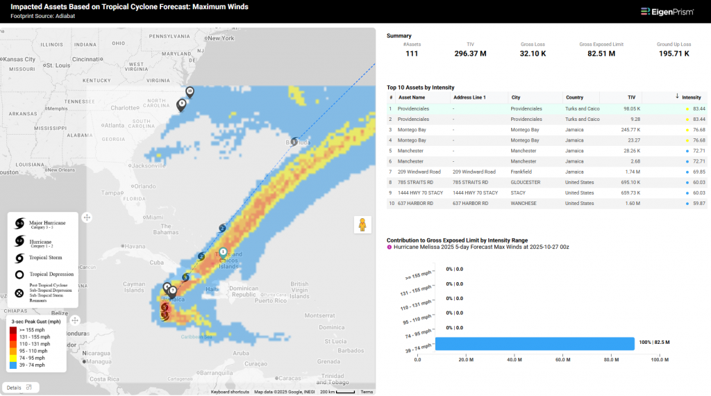
All EigenPrism® users can assess the forecast of Hurricane Melissa using the following report template:
This report template consists of the following wind and flood footprints: Wind Arrival Times from NOAA, Tropical Cyclone Forecast Maximum Winds, 5-Day and 3-Day Flood Potential from Adiabat, and Wind Probabilities (34 kt & 64 kt) from Hurricane Mapping. The pages auto-update with the latest available data.
NHC Tropical Cyclone WMS Layers
EigenPrism users can also view the latest official NHC forecast track alongside event footprints using the Tropical Cyclones WMS layer.
Here’s how you can access the WMS layers:
- On the analysis or report page, click the overlays button in the top right section of the map.
- Click “+Add an Overlay” and choose “Add a WMS layer”
- Search for NHC Tropical Cyclones and then click on Tropical Cyclone Forecast Track
Reask
Subscribers of Reask can use these real-time footprints on EigenPrism® to quickly assess the wind impact:
- Hurricane MELISSA Metryc 50th Percentile Windspeed Intensity Footprint from Reask as of Oct 28, 2025
Post Event
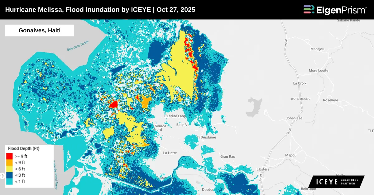
ICEYE
Subscribers of ICEYE in EigenPrism can assess the impact of flood inundation, using the following event footprints:
Windstorm Dataset
All EigenPrism® users can assess the impact of Hurricane Melissa using the following report template:
The report template consists of the following wind footprints: Past max winds by Adiabat and Past wind swath by Hurricane Mapping. The pages auto-update with the latest available data.
Alerts
Users who have alerts set on their exposures for the relevant event sets, like those from NOAA, Adiabat & Hurricane Mapping, will receive alerts (if the event footprints impact these exposures). To learn more about how to set an alert on a specific event set, check out this help center article. Feel free to contact us at Prism.Support@eigenrisk.com or reach out directly to your Customer Success Manager with any questions or concerns. Our team is here to assist you with setting alerts, understanding report templates, and maximizing the actionable insights available through EigenPrism®.
Oct 23 | Tropical Storm Melissa Expected to Become Major Hurricane, Threatens Caribbean Countries
Tropical Storm Melissa is forecast to intensify into a hurricane by the weekend as it moves gradually across the Caribbean on Thursday. Millions across Jamaica, Haiti, and the Dominican Republic are bracing for torrential rain, potential landslides, and powerful winds, with forecasts suggesting Melissa could strengthen into a Category 4 hurricane by Monday.
Between Friday and Sunday, the storm is expected to unleash heavy rainfall, posing a risk of flooding and mudslides across multiple Caribbean countries. According to the latest information from the NHC, Tropical Storm Melissa is currently located about 275 miles to the southwest of Port-au-Prince, Haiti, and about 215 miles to the southeast of Kingston, Jamaica, with maximum sustained winds of around 50 mph.
According to NHC, the Jamaican government has issued a Hurricane Watch for the island, upgrading the earlier Tropical Storm Watch to a warning. Meanwhile, a Hurricane Watch has also been declared for Haiti’s southwestern peninsula, extending from the Dominican Republic border to Port-au-Prince. A direct hit on the mainland US is unlikely, but not impossible. At this time, the storm’s most likely impact to the US could be some rough surf and rip currents along the East Coast next week.
Actionable Analytics on EigenPrism
Windstorm & Flood Datasets
Forecast
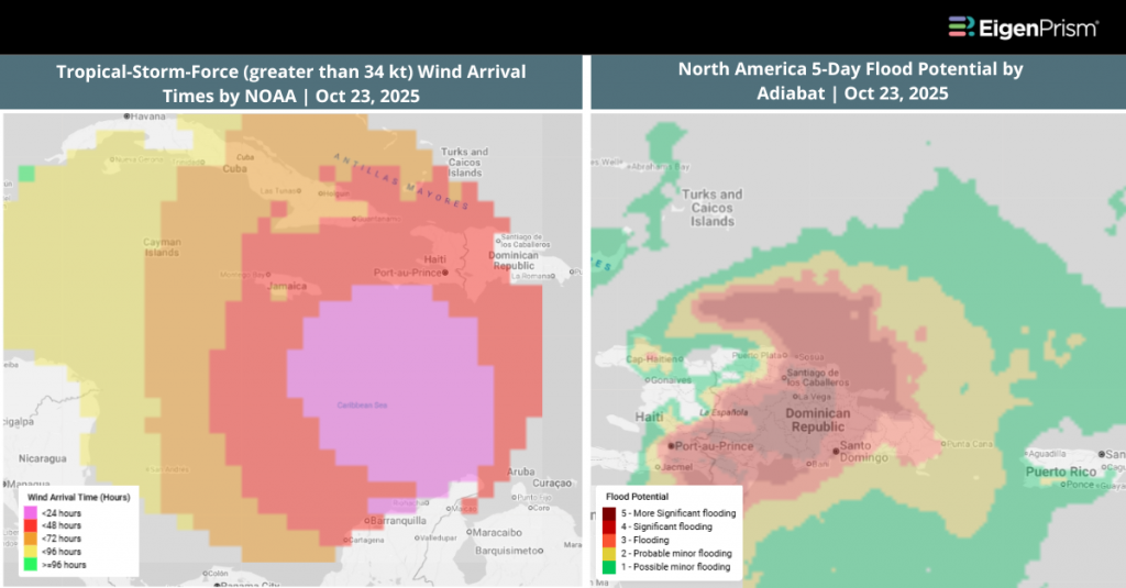
All EigenPrism® users can assess the forecast of the Tropical Storm Melissa using the following report template:
This report template consists of the following wind and flood footprints: Wind Arrival Times from NOAA, Tropical Cyclone Forecast Maximum Winds, 5-Day and 3-Day Flood Potential from Adiabat, and Wind Probabilities (34 kt & 64 kt) from Hurricane Mapping. The pages auto-update with the latest available data.
Alerts
Users who have alerts set on their exposures for the relevant event sets, like those from NOAA, Adiabat & Hurricane Mapping, will receive alerts (if the event footprints impact these exposures). To learn more about how to set an alert on a specific event set, check out this help center article. Feel free to contact us at Prism.Support@eigenrisk.com or reach out directly to your Customer Success Manager with any questions or concerns. Our team is here to assist you with setting alerts, understanding report templates, and maximizing the actionable insights available through EigenPrism®.
Download the EigenAlert Mobile App Today!
With the EigenAlert mobile app, monitor alerts and impacted assets without being tied to your desk.

How to Get Started:
- Scan the QR code using your phone to download the app.
- Log in with your existing EigenPrism credentials.
- Begin accessing your alerts instantly.