Chantal Becomes a Tropical Depression After Landfall, But Flash Floods and Rip Currents Persist
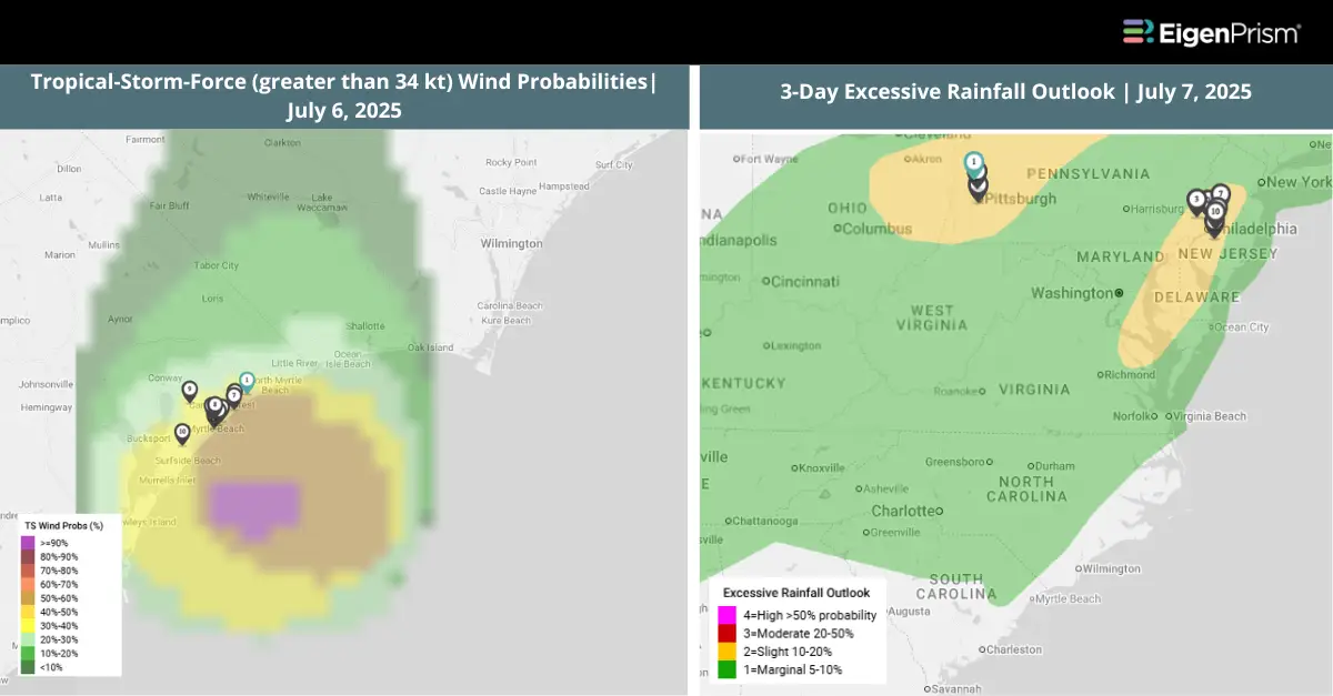
Tropical Storm Chantal weakened to a tropical depression early Sunday after coming ashore in South Carolina. The storm made landfall near Litchfield Beach around 4 a.m. ET, according to the National Hurricane Center (NHC) in Miami. Chantal is forecast to continue weakening as it moves northeast toward southern Virginia by Monday.
Heavy rainfall continues to cause significant flooding, particularly in central North Carolina and southern Virginia. Flash flood concerns continue across portions of south-central and eastern Virginia, southern and eastern Maryland, Delaware, southern New Jersey, and southeastern Pennsylvania. Additionally, dangerous surf and rip currents persist along beaches from northeastern Florida up to the Mid-Atlantic.
Actionable Analytics on EigenPrism
Post-Event
Flood Datasets
Subscribers of ICEYE on EigenPrism can use this footprint to quickly assess the impact of the flood inundation:
Tropical Cyclone Flood – TS Chantal Southeastern US – Flood Inundation as of Jul 09, 2025
Forecast
Windstorm and Flood Dataset
All EigenPrism® users can assess the forecast of the tropical cyclone using the following report template:
Tropical Storm Chantal, July 2025, Forecast Impact Report Template
This report template consists of the following wind and flood footprints:
- 5-day Forecast Maximum Winds by Adiabat
- Forecast Wind Swath by Hurricane Mapping
- Tropical-Storm-Force (greater than 34 kt) Wind Arrival Times by NOAA
- 5-day Tropical-Storm-Force (greater than 34 kt) Wind Probabilities by Hurricane Mapping
- 5-day Hurricane-Force (greater than 64 kt) Wind Probabilities by Wind Hurricane Mapping
- WPC 3-Day Excessive Rainfall Outlook by NWS
- NA 5-day Flood Potential from Adiabat
- US Flood Outlook by NWS
The pages auto-update with the latest available data.
Alerts
Users who have alerts set on their exposures for the relevant event sets, like those from Adiabat & Hurricane Mapping will receive alerts (if the event footprints impact these exposures).
To learn more about how to set an alert on a specific event set, check out this help center article.
Feel free to contact us at Prism.Support@eigenrisk.com or reach out directly to your Customer Success Manager with any questions or concerns. Our team is here to assist you with setting alerts, understanding report templates, and maximizing the actionable insights available through EigenPrism®.
Tropical Storm Chantal Forms Off South Carolina, Poses Flood & Storm-Surge Threat
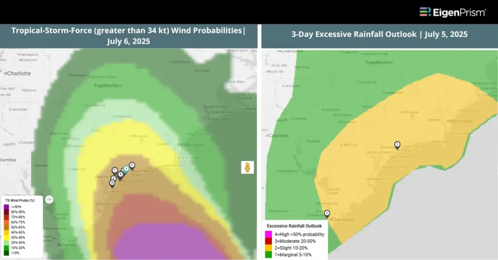
Tropical Chantal formed off the coast of South Carolina on Saturday morning, July 5th. The National Weather Service has issued a tropical storm watch for Charleston County in South Carolina and tropical storm warnings for Georgetown County and Henry County (home to Myrtle Beach) in South Carolina.
Flood warnings have been issued for Dillon County in South Carolina, and Columbus and Brunswick Counties in North Carolina.
The storm has sustained winds of approximately 45mph, with gusts as high as 55mph, as of Saturday evening and is expected to intensify slightly ahead of a landfall between Charleston and Georgetown in the early morning hours of Sunday, July 6th. Rapid weakening is expected shortly after landfall.
The main threat with Chantal is flooding and storm surge. Anywhere from 2-4 inches of rain will fall across portions of the Carolinas on Sunday, with local amounts of up to six inches. Water heights could reach 1-2 feet between Edisto Beach, SC and Surf City, NC if the peak surge occurs during high tide. Isolated tornadoes are possible tonight and Sunday across portions of eastern South Carolina and eastern North Carolina.
Actionable Analytics on EigenPrism
Forecast
Windstorm and Flood Dataset
All EigenPrism® users can assess the forecast of the tropical cyclone using the following report template:
Tropical Storm Chantal, July 2025, Forecast Impact Report Template
This report template consists of the following wind and flood footprints:
- 5-day Forecast Maximum Winds by Adiabat
- Forecast Wind Swath by Hurricane Mapping
- Tropical-Storm-Force (greater than 34 kt) Wind Arrival Times by NOAA
- 5-day Tropical-Storm-Force (greater than 34 kt) Wind Probabilities by Hurricane Mapping
- 5-day Hurricane-Force (greater than 64 kt) Wind Probabilities by Wind Hurricane Mapping
- WPC 3-Day Excessive Rainfall Outlook by NWS
- NA 5-day Flood Potential from Adiabat
- US Flood Outlook by NWS
The pages auto-update with the latest available data.
Alerts
Users who have alerts set on their exposures for the relevant event sets, like those from Adiabat & Hurricane Mapping will receive alerts (if the event footprints impact these exposures).
To learn more about how to set an alert on a specific event set, check out this help center article.
Feel free to contact us at Prism.Support@eigenrisk.com or reach out directly to your Customer Success Manager with any questions or concerns. Our team is here to assist you with setting alerts, understanding report templates, and maximizing the actionable insights available through EigenPrism®.
Download the EigenAlert Mobile App Today!
With the EigenAlert mobile app, monitor alerts and impacted assets without being tied to your desk.

How to Get Started:
- Scan the QR code using your phone to download the app.
- Log in with your existing EigenPrism credentials.
- Begin accessing your alerts instantly.