Tornadoes and Severe Storms Slam Mississippi, Tennessee, and Ohio Valleys
A new wave of tornadoes swept through the Mississippi, Tennessee, and Ohio Valleys on Tuesday afternoon as powerful thunderstorms moved across the region. Tornado touchdowns were confirmed in Alabama, Tennessee, and Illinois by late evening, with numerous Tornado Warnings issued in response to the widespread severe weather.
Forecasters expect thunderstorms to develop from Thursday afternoon into the night, stretching from central and southern Texas into southern Oklahoma and southwestern Arkansas. Meanwhile, rain is forecast to reach major Northeast cities, including Washington, D.C., and New York on Wednesday, followed by Boston on Thursday and Friday.
Actionable Analytics on EigenPrism
Post-Event
Severe Thunderstorm Datasets
All EigenPrism users can assess the impact of these tornadoes that occurred on May 16, 2025, to May 20, 2025 using the following report template:
US Tornadoes – May 16 to May 20, 2025 – Post-Event Impact Report Template
This report template consists of:
- 55 survey footprints from NWS for May 16 to May 20. These are all grouped on a single page. These are available as of May 21. Other tornado damage survey footprints from NWS will be available in EigenPrism as soon as NWS releases them.
- 24-hr Tornado Reports from May 17 to May 20, 2025 1159 GMT from NOAA.
Subscribers of Canopy Weather in EigenPrism can assess the impact of the tornado using the following event footprints from May 20, 2025:
US Tornado Proximity Map as of May 20, 2025 by Canopy Weather
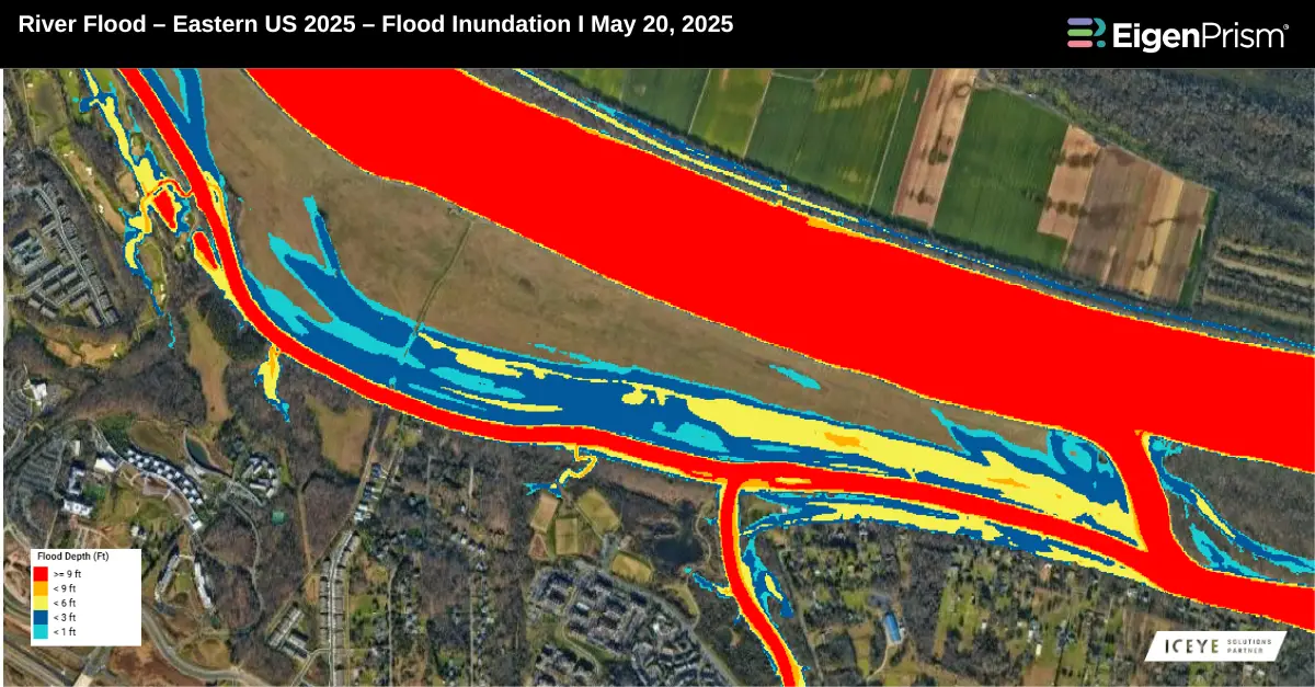
Subscribers of ICEYE in EigenPrism can assess the impact of flood inundation, using the following event footprint:
River Flood – Eastern US 2025 – Flood Inundation by ICEYE as of May 20, 2025
Forecast
Severe Thunderstorm Datasets
All EigenPrism® users can assess the forecast of this severe weather event using the following report template:
US Severe Weather 2025 Forecast Report Template
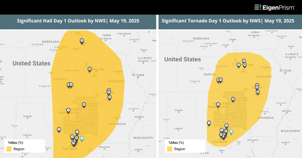
This report template enables you to assess the severe weather forecast based on the data from NWS and Adiabat. The footprints in the template display the following:
- Significant Tornado, Hail, and Wind Day 1 Outlooks
- WPC 3-Day Excessive Rainfall Outlook
- NA 5-Day & 3-Day Flood Potential
- US Flood Outlook
The pages auto-update with the latest available data.
May 19 | Deadly Storms Batter Midwest and South, With More Severe Weather Ahead
At least 28 fatalities have been confirmed following a series of destructive storms that moved across the lower Midwest and southern US over the weekend, with Missouri and Kentucky among the hardest hit. As the region recovers, the National Weather Service (NWS) warns that another round of severe weather could return between Monday and Tuesday.
A slight risk advisory for excessive rainfall remains in place from eastern Kansas and Oklahoma through the Ozark Mountains of Missouri and Arkansas, effective through Monday morning.
Flash flooding remains a concern, particularly on Tuesday, as heavy rain continues. Meanwhile, widespread power outages have compounded recovery efforts, with over 49,000 customers in Missouri and more than 26,000 in Kentucky still without electricity as of Sunday, according to PowerOutage.us.
Actionable Analytics on EigenPrism
Post-Event
Severe Thunderstorm Datasets
All EigenPrism users can assess the impact of these tornadoes that occurred on May 16, and May 17, 2025, using the following report template:
US Tornadoes – May 16 – May 17, 2025 – Post-Event Impact Report Template
This report template consists of:
- Damage survey footprints from NWS for May 16 and May 19. These are all grouped on a single page. These are available as of May 19. Other tornado damage survey footprints from NWS will be available in EigenPrism as soon as they are released by NWS.
- 24-hr Tornado Reports ending 2025-05-17 1159 GMT from NOAA.
Subscribers of Canopy Weather in EigenPrism can assess the impact of the tornado using the following event footprints from May 18, 2024
US Tornado Proximity Map as of May 18, 2025 by Canopy Weather
Rapid Damage Assessment
Vexcel Aerial Imagery
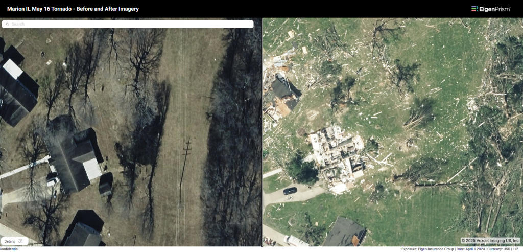
Subscribers of Vexcel can now access the imagery of tornado-damaged areas in St. Louis, MO, Somerset, KY, Marion, IL, Bloomfield, IL, and surrounding areas
Marion, Illinois
St. Louis, Missouri

To view the imagery for your exposure, click here and learn how to use Vexcel* imagery in EigenPrism.
*only available for subscribers of Vexcel in EigenPrism
Forecast
Severe Thunderstorm Datasets
All EigenPrism® users can assess the forecast of this severe weather event using the following report template:
US Severe Weather 2025 Forecast Report Template
This report template enables you to assess the severe weather forecast based on the data from NWS and Adiabat. The footprints in the template display the following:
- Significant Tornado, Hail, and Wind Day 1 Outlooks
- WPC 3-Day Excessive Rainfall Outlook
- NA 5-Day & 3-Day Flood Potential
- US Flood Outlook
The pages auto-update with the latest available data.
May 17 | Deadly Tornado Outbreak Devastates Missouri and Kentucky, Severe Weather Continues
A violent storm system spawned multiple destructive tornadoes across the central US, resulting in at least 21 fatalities in Missouri and southeastern Kentucky. Kentucky alone reported 14 deaths, with extensive devastation in Laurel County and surrounding areas, prompting ongoing rescue operations. In Missouri, a powerful tornado severely impacted the St. Louis area, killing five people, injuring dozens, and damaging approximately 5,000 buildings. Additional fatalities occurred in Scott County, and roughly 560,000 homes and businesses remain without power across multiple states.
While this storm system weakens over the Southeast, another severe weather threat emerges, placing more than 20 million residents in the Southwest and southern Great Plains, particularly around the Dallas-Fort Worth area, at risk through early next week.
Actionable Analytics on EigenPrism
Post-Event
Severe Thunderstorm Datasets
All EigenPrism users can assess the impact of these tornadoes that occurred on May 16, 2025 and May 17, 2025, using the following report template:
US Tornadoes – May 16 – May 17, 2025 – Post-Event Impact Report Template
This report template consists of:
- Damage survey footprints from NWS for May 16 and May 17. These are all grouped on a single page. These are available as of May 19. Other tornado damage survey footprints from NWS will be available in EigenPrism as soon as they are released by NWS.
- 24-hr Tornado Reports ending 2025-05-17 1159 GMT from NOAA.
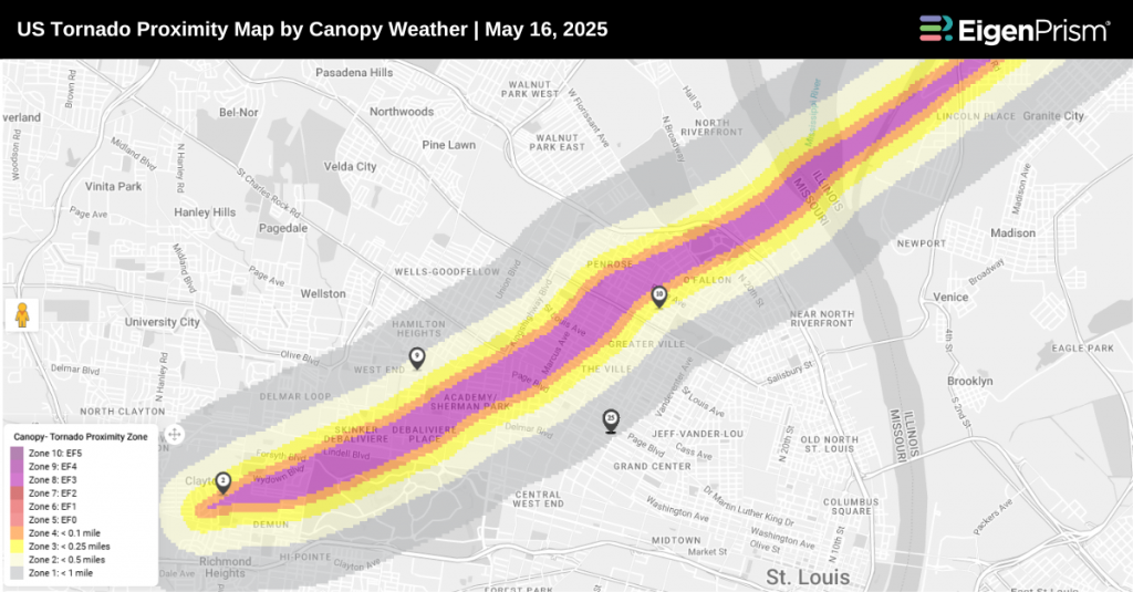
Subscribers of Canopy Weather in EigenPrism can assess the impact of the tornado using the following event footprints from May 16, 2025:
US Tornado proximity map for May 16, 2025 as of 2025-05-17 12:10:04 UTC by Canopy Weather
Forecast
Severe Thunderstorm Datasets
All EigenPrism® users can assess the forecast of this severe weather event using the following report template:
US Severe Weather 2025 Forecast Report Template
This report template enables you to assess the severe weather forecast based on the data from NWS and Adiabat. The footprints in the template display the following:
- Significant Tornado, Hail, and Wind Day 1 Outlooks
- WPC 3-Day Excessive Rainfall Outlook
- NA 5-Day & 3-Day Flood Potential
- US Flood Outlook
The pages auto-update with the latest available data.
Rapid Damage Assessment
Vexcel Aerial Imagery
Vexcel aerial imagery will be made available in EigenPrism as soon as the imagery is available from them.
Vexcel’s Gray Sky team is preparing to begin aerial imagery collection over St. Louis, as soon as weather conditions allow. For the latest updates on Vexcel’s coverage of the St Louis tornado, you can check their blog.
Tornadoes Strike Wisconsin as Severe Storm Outbreak Expands Into Ohio Valley
At least nine tornadoes touched down across Minnesota and Wisconsin on Thursday evening. The Storm Prediction Center received nearly 400 reports of severe weather.
The Storm Prediction Center has issued a Moderate Risk (level 4 of 5) from the Missouri Bootheel through southern Illinois, southern Indiana and central Kentucky, with an Enhanced Risk (level 3) extending to St Louis, Indianapolis, Louisville, and Nashville.
More than six million people face the potential for strong tornadoes, destructive straight-line winds, very large hail and flash flooding as afternoon supercells merge into an overnight bow-echo.
Actionable Analytics on EigenPrism
Post-Event
Severe Thunderstorm Datasets
All EigenPrism® users can assess the Maximum Expected Size of Hail (MESH) over the past 24 hours using the following footprint:
Forecast
Severe Thunderstorm Datasets
All EigenPrism® users can assess the forecast of this severe weather event using the following report template:
US Severe Weather 2025 Forecast Report Template
This report template enables you to assess the severe weather forecast based on the data from NWS and Adiabat. The footprints in the template display the following:
- Significant Tornado, Hail, and Wind Day 1 Outlooks
- WPC 3-Day Excessive Rainfall Outlook
- NA 5-Day & 3-Day Flood Potential
- US Flood Outlook
The pages auto-update with the latest available data.
Severe Storm Threat Looms Over Midwest — Tornadoes and Flash Flooding Possible
The National Weather Service (NWS) has issued a warning for potentially severe weather across the Midwest this week, with multiple states at risk including Michigan, Wisconsin, Illinois, Indiana, and Ohio. Forecasts indicate the possibility of large hail, damaging wind gusts, and isolated tornadoes. In addition, heavy rainfall associated with these storms could result in localized or scattered flash flooding. Southwest Michigan is currently considered the area of highest concern.
According to the Storm Prediction Center, areas from Manistee to Lansing in West Michigan are currently under an Enhanced Risk (level 3 of 5) for severe weather. Meanwhile, the eastern part of the state is under a Slight Risk (level 2 of 5) as the storm system progresses eastward
Actionable Analytics on EigenPrism
Forecast
Severe Thunderstorm Datasets
All EigenPrism® users can assess the forecast of this severe weather event using the following report template:
US Severe Weather 2025 Forecast Report Template
This report template enables you to assess the severe weather forecast based on the data from NWS and Adiabat. The footprints in the template display the following:
- Significant Tornado, Hail, and Wind Day 1 Outlooks
- WPC 3-Day Excessive Rainfall Outlook
- NA 5-Day & 3-Day Flood Potential
- US Flood Outlook
The pages auto-update with the latest available data.
Alerts
Users who have alerts set on their exposures for the relevant event sets, like those from NWS, Adiabat, & Canopy Weather will receive alerts (if the event footprints impact these exposures).
To learn more about how to set an alert on a specific event set, check out this help center article.
Feel free to contact us at Prism.Support@eigenrisk.com or reach out directly to your Customer Success Manager with any questions or concerns. Our team is here to assist you with setting alerts, understanding report templates, and maximizing the actionable insights available through EigenPrism®.
Download the EigenAlert Mobile App Today!
With the EigenAlert mobile app, monitor alerts and impacted assets without being tied to your desk.

How to Get Started:
- Scan the QR code using your phone to download the app.
- Log in with your existing EigenPrism credentials.
- Begin accessing your alerts instantly.