Torrential Rain, Damaging Winds, and Tornado Threat Slam Gulf Coast States
Severe weather wreaked havoc across parts of the Gulf Coast on Wednesday morning, bringing torrential rains, damaging wind gusts, and even reports of a tornado. Storm damage was reported near New Orleans in Jefferson Parish on Wednesday, a possible tornado tore across the region.
In New Orleans, a line of storms continues to deliver repeated rounds of heavy rainfall. Metairie, just outside New Orleans, received 4.56 inches, according to the National Weather Service in New Orleans.
Torrential rain led to numerous Flash Flood Warnings in Texas and Louisiana from Tuesday night into Wednesday morning. Flood Watches remain in effect along the southeastern Louisiana coast, including New Orleans, and into the Gulf Coast of Mississippi and Alabama into Thursday.
Actionable Analytics on EigenPrism
Post-Event
Flood Datasets
ICEYE
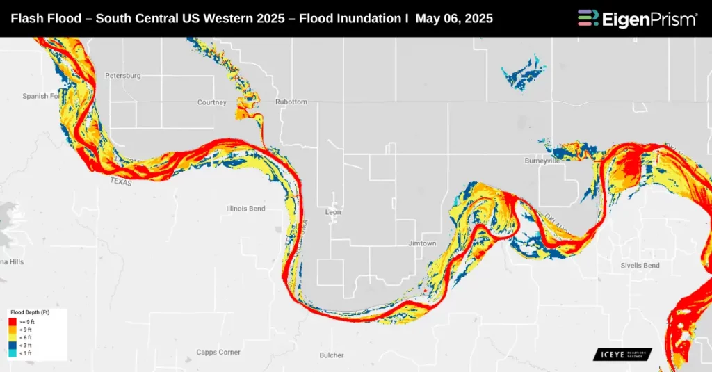
Subscribers of ICEYE can use these footprints on EigenPrism® to quickly assess the impact of flood inundation:
Flash Flood – South Central US Western 2025 – Flood Inundation as of May 07, 2025
Canopy Weather
Tornado
Subscribers of Canopy Weather in EigenPrism can assess the impact of the tornado using the following event footprints from May 07, 2025:
US Tornado Proximity Map by Canopy Weather as of May 07, 2025
Hail
Subscribers of Canopy Weather in EigenPrism can assess the impact of the hail using the following event footprints from May 07, 2025:
Daily CONUS Hail-Prelim 3 Swath Map as of May 07, 2025
Wind
Subscribers of Canopy Weather in EigenPrism can assess the impact of the wind using the following event footprints from May 07, 2025:
Daily CONUS Peak Wind Gusts-Prelim 3 as of May 07, 2025
Forecast
Severe Thunderstorm Datasets
All EigenPrism® users can assess the forecast of this severe weather event using the following report template:
US Severe Weather 2025 Forecast Report Template
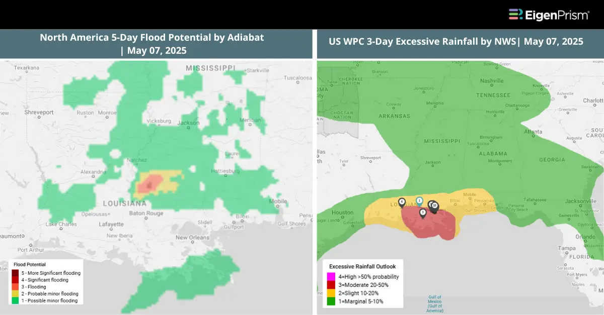
This report template enables you to assess the severe weather forecast based on the data from NWS and Adiabat. The footprints in the template display the following:
- Significant Tornado, Hail, and Wind Day 1 Outlooks
- WPC 3-Day Excessive Rainfall Outlook
- NA 5-Day & 3-Day Flood Potential
- US Flood Outlook
The pages auto-update with the latest available data.
Alerts
Users who have alerts set on their exposures for the relevant event sets, like those from NWS, Adiabat, & Canopy Weather will receive alerts (if the event footprints impact these exposures).
To learn more about how to set an alert on a specific event set, check out this help center article.
Feel free to contact us at Prism.Support@eigenrisk.com or reach out directly to your Customer Success Manager with any questions or concerns. Our team is here to assist you with setting alerts, understanding report templates, and maximizing the actionable insights available through EigenPrism®
May 07 | Severe Storms Slam the South with Flash Flooding, Hail, and Tornadoes
A slow-moving storm system continues to batter the southern US this week, particularly across Texas, Louisiana, and Mississippi. It consists of a dangerous combination of flash flooding, large hail, damaging winds, and tornadoes.
Heavy rain is expected through Wednesday, falling on ground already soaked by recent storms. This increases the risk of rapid flooding across low-lying and urban areas.
On Tuesday, severe thunderstorms unleashed torrential rain and hail as large as Ping-Pong balls in parts of Texas and Louisiana. Tornadoes were also reported, tearing roofs from homes, toppling trees, and knocking out power. The threat of more severe weather, including additional tornadoes, remains in the forecast through the coming days.
Actionable Analytics on EigenPrism
Forecast
Severe Thunderstorm Datasets
All EigenPrism® users can assess the forecast of this severe weather event using the following report template:
US Severe Weather 2025 Forecast Report Template
This report template enables you to assess the severe weather forecast based on the data from NWS and Adiabat. The footprints in the template display the following:
- Significant Tornado, Hail, and Wind Day 1 Outlooks
- WPC 3-Day Excessive Rainfall Outlook
- NA 5-Day & 3-Day Flood Potential
- US Flood Outlook
The pages auto-update with the latest available data.
Post-Event
Flood Datasets
ICEYE
Subscribers of ICEYE can use these footprints on EigenPrism® to quickly assess the impact of flood inundation:
Flash Flood – South Central US Western 2025 – Flood Inundation as of May 06, 2025
Canopy Weather
Tornado
Subscribers of Canopy Weather in EigenPrism can assess the impact of the tornado using the following event footprints from May 06, 2025:
US Tornado Proximity Map by Canopy Weather as of May 06, 2025
Hail
Subscribers of Canopy Weather in EigenPrism can assess the impact of the hail using the following event footprints from May 06, 2025:
Daily CONUS Hail-Prelim 3 Swath Map as of May 06, 2025
Wind
Subscribers of Canopy Weather in EigenPrism can assess the impact of the wind using the following event footprints from May 06, 2025:
Daily CONUS Peak Wind Gusts-Prelim 3 as of May 06, 2025
Alerts
Users who have alerts set on their exposures for the relevant event sets, like those from NWS, Adiabat, & Canopy Weather will receive alerts (if the event footprints impact these exposures).
To learn more about how to set an alert on a specific event set, check out this help center article.
Feel free to contact us at Prism.Support@eigenrisk.com or reach out directly to your Customer Success Manager with any questions or concerns. Our team is here to assist you with setting alerts, understanding report templates, and maximizing the actionable insights available through EigenPrism®.
Download the EigenAlert Mobile App Today!
With the EigenAlert mobile app, monitor alerts and impacted assets without being tied to your desk.

How to Get Started:
- Scan the QR code using your phone to download the app.
- Log in with your existing EigenPrism credentials.
- Begin accessing your alerts instantly.