Arctic Blast Brings Blizzard Conditions and Tornado Alerts While Blanketing Kansas with 18 Inches of Snow
An arctic blast is sweeping through the southern US as a powerful winter storm moves from the Ohio River Valley to the mid-Atlantic, causing widespread travel disruptions and power outages. The storm shut down interstates in Kentucky, closed an airport in Kansas, and left nearly 100,000 customers without power from Missouri to Kentucky.
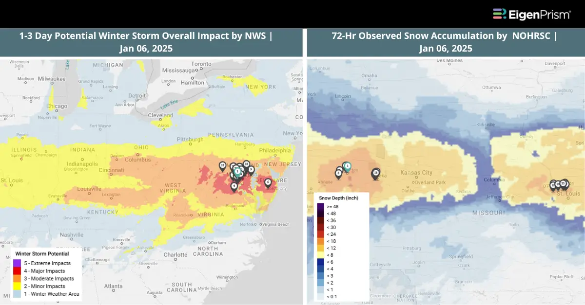
Snow, freezing rain, and sleet are spreading from the Missouri Valley to the mid-Atlantic, with Wichita experiencing thundersnow. Chapman, Kansas, recorded 18 inches of snowfall—the highest so far—while areas from eastern Kansas to southern Missouri reported over half an inch of ice.
Winter storm warnings stretch from the mid-Mississippi and Ohio valleys to the mid-Atlantic, affecting cities like Baltimore, Cincinnati, and Washington, D.C. Wind gusts up to 50 mph in the Central Plains are creating whiteout conditions, making travel extremely dangerous.
As a result of the winter storm system, severe thunderstorms impacted the South. The threat of severe weather began Sunday afternoon and continued overnight, sweeping from the Sabine River Valley in East Texas into the mid-South and lower Mississippi Valley. The NOAA Storm Prediction Center issued a Tornado Watch for eastern Arkansas, southeastern Louisiana, and much of Mississippi through Sunday night.
NOAA’s SPC classified this region as Level 3 out of 5 on the severe weather scale on Sunday, indicating a heightened risk of strong storms. The affected areas also had the potential for EF-2 or stronger tornadoes.
Arctic Blast Brings Blizzard Conditions and Tornado Alerts: Actionable Analytics on EigenPrism
Post-Event
All EigenPrism® users can assess the post-event impact of the snow accumulation using the following event footprint:
72-hour observed snow accumulation as of Jan 06, 2025, by NOHRSC
Canopy Weather
Subscribers of Canopy Weather can assess the impact of winds and hail from Jan 05- 06, 2025, using this footprint within EigenPrism®:
Daily CONUS Peak Wind Gusts- Prelim 3 as of Jan 05, 2025
Daily CONUS Hail Swath Map-Final as of Jan 05, 2025
Forecast
All EigenPrism® users can assess the forecasts associated with this event using the following report templates:
US Winter Storm Forecast Template
The report template auto-updates with the latest available forecasts, which include:
- 72-hr Forecast Freezing Rain Accumulation
- 72-hr Forecast Snow Accumulation
- Potential Winter Storm Overall Impact
Tornado
All EigenPrism® users can assess the forecast of the tornado using the following event footprint:
Significant Tornado Day 1 Outlook as of Jan 05, 2025 by NWS
Winter Severity Component Report Template
This report template consists of the summary level (Potential Overall Winter Storm Impact) and all six component WSSI datasets from NWS:
- Potential Snow Amount Impact
- Potential Snow Load Impact
- Potential Ground Blizzard Impact
- Potential Ice Accumulation Impact
- Potential Blowing Snow Impact
- Potential Winter Storm Flash Freeze Impact
The report template auto-updates with the latest available datasets.
Jan 04 | Winter Storm Triggers Warnings Across Central US to Midwest with Heavy Snow and Freezing Rain
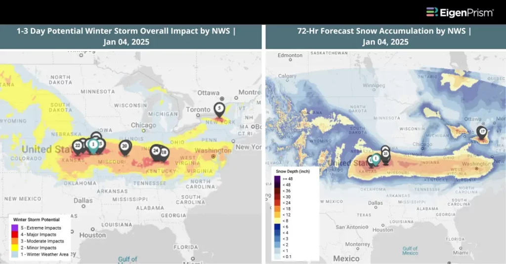
A massive winter storm, tracked by the National Weather Service, is gearing up to unleash a powerful mix of heavy snow, sleet, freezing rain, and ice across the central United States this weekend. As it barrels toward the mid-Atlantic by Monday, a polar vortex looms in its wake, threatening to plunge temperatures to record-breaking lows—possibly marking this January as the coldest in a decade.
A winter storm warning has been issued for large portions of Illinois, Kansas, Missouri, and Nebraska. Heavy snowfall or a wintry mix is anticipated to begin late Saturday. Cities like Kansas City and St. Louis are included in the warning area, where travel is expected to become hazardous, and power outages are likely. In Montana, gusty winds and blowing snow have prompted winter storm warnings due to reduced visibility.
Southern Missouri is under an ice storm warning, with significant icing predicted from late Saturday through early Monday. Icy roads in the region will likely become impassable, and widespread power outages are expected.
The northern and central Rockies will also see significant snowfall, with the wintry weather extending into the Plains by evening and continuing into the mid-Mississippi Valley overnight. Forecasters predict at least 6 inches of snow in the Central Plains and Midwest, particularly in areas from northeastern Kansas through parts of Missouri, central Illinois, southern Indiana, Ohio, and possibly northern Kentucky. Some locations could see over a foot of snow where heavier bands persist.
Winter Storm Triggers Warnings Across Central US to Midwest with Heavy Snow and Freezing Rain: Actionable Analytics on EigenPrism
Forecast
All EigenPrism® users can assess the forecasts associated with this event using the following report templates:
US Winter Storm Forecast Template
The report template auto-updates with the latest available forecasts, which include:
- 72-hr Forecast Freezing Rain Accumulation
- 72-hr Forecast Snow Accumulation
- Potential Winter Storm Overall Impact
Winter Severity Component Report Template
This report template consists of the summary level (Potential Overall Winter Storm Impact) and all six component WSSI datasets from NWS:
- Potential Snow Amount Impact
- Potential Snow Load Impact
- Potential Ground Blizzard Impact
- Potential Ice Accumulation Impact
- Potential Blowing Snow Impact
- Potential Winter Storm Flash Freeze Impact
The report template auto-updates with the latest available datasets.
Escape the News Cycle | Get Alerts Automatically for Events Impacting Your Assets
With EigenPrism Alerts, you can free yourself from constant event monitoring. Set up personalized alerts based on predefined impact thresholds and choose how you receive them – via email, SMS, or directly within EigenPrism. This way, you can stay informed on your own terms, focusing only on the events that truly matter to your assets.
Set your alerts now.
Don’t have access to EigenPrism®?
Sign up for a trial account and access full impact reports of all events. Contact us, and we’ll set up a trial account for you.