Mountain Fire Ravages Ventura County, Thousands Under Evacuation Orders and Over 130 Structures Destroyed
A wildfire in Southern California has destroyed 132 structures—mostly homes—in less than two days, fire officials reported on Thursday, as forecasts predict that the raging winds will soon diminish. The blaze ignited on Wednesday morning in Ventura County and has expanded to about 32 square miles (83 square kilometers) with only 5% containment. The cause of the fire has yet to be determined.
According to Cal Fire, wildfire has scorched more than 20,400 acres, propelled by powerful winds gusting over 60 mph. The extreme weather conditions led forecasters to issue a rare “particularly dangerous situation” red flag warning, highlighting the potential for “life-threatening” fire behavior.
Ten people have been injured during the fire, most suffering from smoke inhalation or other non-life-threatening injuries. Fire officials also noted that 88 additional structures have been damaged, although they did not specify whether the damage was from flames, water, or smoke.
As of Thursday, approximately 10,000 residents remain under evacuation orders as the Mountain Fire continues to threaten around 3,500 structures in suburban neighborhoods, ranches, and agricultural areas near Camarillo in Ventura County. In response to the heightened risk, power has been shut off to nearly 70,000 customers across five counties. Throughout the region, wind gusts up to 40 mph are still possible through Friday morning but are expected to decrease in the afternoon. Winds are likely to drop to 20-30 mph and increasing humidity levels are anticipated to assist firefighting efforts.
Mountain Fire Ravages Ventura County: Actionable Analytics on EigenPrism
ICEYE
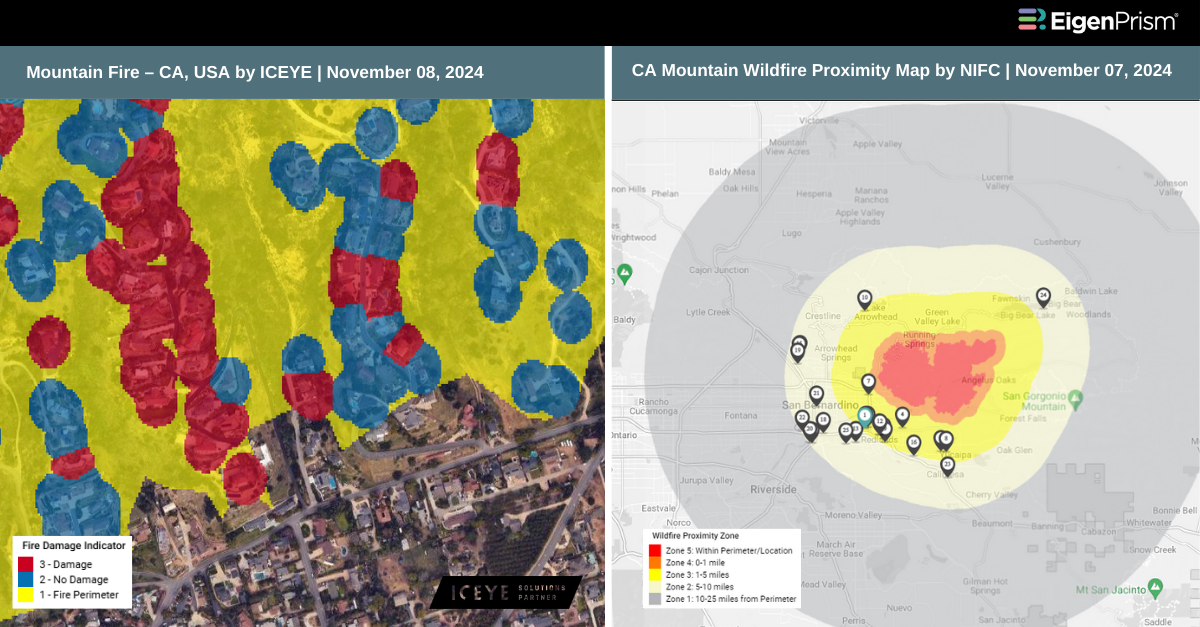
Subscribers of ICEYE can use the following real-time footprints on EigenPrism®, to quickly assess the impact of wildfire:
Mountain Fire – CA, USA as of 2024-11-08
Canopy Weather
Subscribers of Canopy Weather can assess the impact of Winds from Nov 07, 2024 using this footprint within EigenPrism®:
Daily CONUS Peak Wind Gusts- Prelim 3 as of 2024-11-07
All EigenPrism® users can assess the impact of AQI using this footprint within EigenPrism®:
Daily Air Quality Index (AQI) across North America as of 2024-11-07
All EigenPrism® users can assess the impact on and near the active fire area from Nov 07, 2024 using the following report template:
California Mountain Wildfire 2024 Report Template
The report template has the latest available footprints, which include:
- CA Mountain Wildfire Proximity Map from NIFC
- CA Mountain Wildfire from NIFC
Nov 07 | Mountain Fire Forces Evacuations as Wildfire Rages in Southern California
 Wildfire season remains intense as gusty winds up to 60 miles per hour fuel a rapidly moving blaze in Southern California. The Mountain Fire has scorched thousands of acres in Ventura County, affecting homes and businesses near Camarillo. Several people were injured when the fire broke out on Wednesday morning. The blaze quickly expanded, prompting evacuation orders for more than 10,000 residents as it threatened approximately 3,500 structures in suburban communities, ranches, and agricultural areas around Camarillo.
According to the Ventura County Fire Department, the fire ignited around 8:50 a.m. near the 7900 block of Balcom Canyon Road and Bradley Road on South Mountain in the Moorpark area. Within an hour, it had grown from 25 acres to 1,000 acres. The Mountain Fire continued to rage throughout the night, burning more than 14,100 acres while remaining at 0% containment.
Aerial footage from local television networks showed numerous homes engulfed in flames across several neighbourhoods as embers spread from one property to another. Other videos captured horses trotting alongside evacuating vehicles. On Wednesday, over 65,000 customers in Southern California were without power as a preventative measure, with upwards of 20,000 affected in Northern California.
Forecasters issued red flag warnings until Thursday for areas from California’s central coast through the San Francisco Bay Area and into northern counties, where strong winds were also expected.
Mountain Fire Forces Evacuations as Wildfire Rages in Southern California: Actionable Analytics on EigenPrism
ICEYE
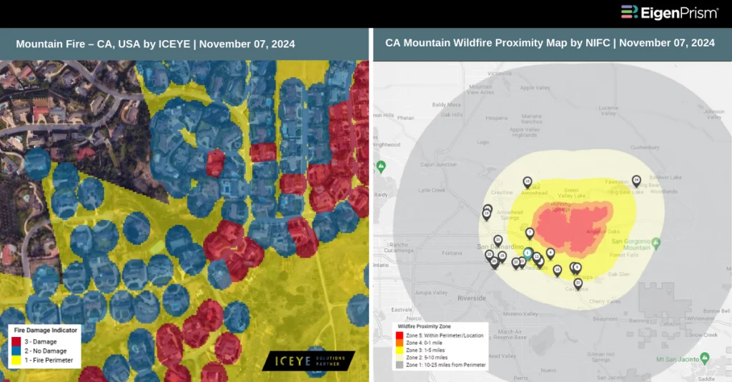
Subscribers of ICEYE can use the following real-time footprints on EigenPrism®, to quickly assess the impact of wildfire:
Mountain Fire – CA, USA as of 2024-11-07
All EigenPrism® users can assess the impact on and near the active fire area using the following report template:
California Mountain Wildfire 2024 Report Template
The report template has the latest available footprints, which include:
- CA Mountain Wildfire Proximity Map from NIFC
- CA Mountain Wildfire from NIFC
Escape the News Cycle | Get Alerts Automatically for Events Impacting Your Assets
With EigenPrism Alerts, you can free yourself from constant event monitoring. Set up personalized alerts based on predefined impact thresholds and choose how you receive them – via email, SMS, or directly within EigenPrism. This way, you can stay informed on your own terms, focusing only on the events that truly matter to your assets.
Set your alerts now.
Don’t have access to EigenPrism®?
Sign up for a trial account and access full impact reports of all events. Contact us, and we’ll set up a trial account for you.