Hurricane Milton Brings Devastating Floods, Tornadoes, and Power Outages to Florida
Hurricane Milton made landfall as a Category 3 storm near Siesta Key, battering Florida with torrential rain and powerful winds. As the storm moved across the state, it weakened to Category 1 but still caused extensive flooding, especially in St. Petersburg, due to 16 inches of rain in just a few hours. This extreme weather has left over 3 million people without power.
particularly in St. Lucie County, where a tornado devastated a mobile home community, destroying 125 homes and causing multiple fatalities. Rescue efforts are ongoing as authorities navigate dangerous conditions caused by downed power lines and trees.
In Tampa, emergency services were halted due to the storm’s high winds and dangerous conditions, while St. Petersburg experienced additional devastation when a crane collapsed, and water services were cut off following a water main break. Residents have been urged to stay indoors as recovery efforts get underway, and authorities warn of continued risks of flooding and storm surge.
Despite Milton’s weakening, officials caution that hazards remain, especially as the storm continues offshore. The widespread damage from flooding and strong winds has left much of the state grappling with blocked roads and power outages, while recovery teams work tirelessly to clear debris and restore essential services.
Hurricane Milton: Actionable Analytics on EigenPrism
Post- Event
All EigenPrism users can assess the post-event impact of Hurricane Milton on the assets alongthe path using the following report template.
Hurricane Milton 2024 Post-Event Impact Report – Template
The report template auto-updates with the latest available footprints, which include:
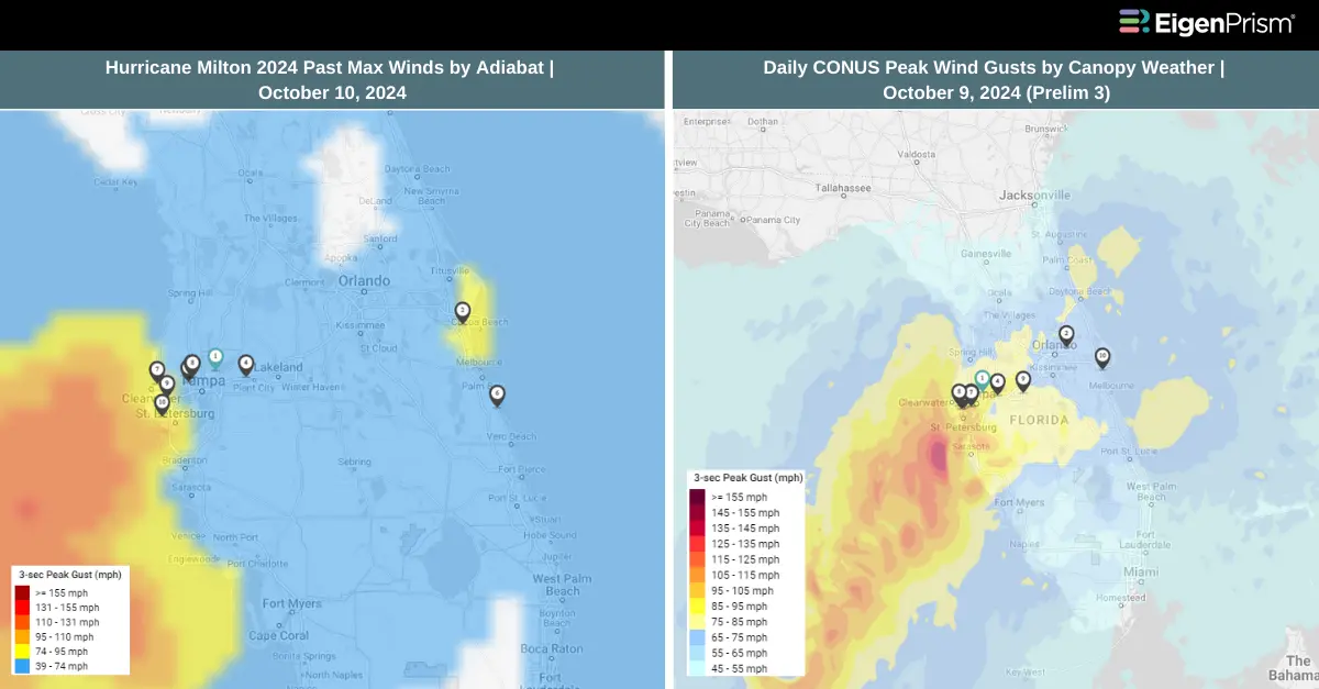
- Hurricane Milton 2024 Past Max Winds by Adiabat
- Hurricane Milton Past Wind Swath – Advisory by Hurricane Mapping
- 24-hr Tornado Reports ending 2024-10-10 1159Z by NOAA
- EF3 Milton Palm Beach Gardens Tornado track on 2024-10-09 by NWS
- EF2 Dixie Acres Tornado track on 2024-10-09 by NWS
- EF1 Cocoa Beach Tornado track on 2024-10-09 by NWS
KatRisk
Subscribers of KatRisk can assess the impact of wind, storm surge & flood using the following report template:
Hurricane Milton 2024 by KatRisk Impact Report Template
The report template auto-updates with the latest available footprints, which include:
- Hurricane Milton Wind Speed Footprint by KatRisk
- Hurricane Milton Storm Surge Footprint by KatRisk
- Hurricane Milton Flood Inundation Footprint by KatRisk
ICEYE
Subscribers of ICEYE can use this footprint on EigenPrism® to quickly assess the impact of flood inundation:
Hurricane Milton Flood Inundation- ICEYE Footprint as of Oct 10
Canopy Weather
Subscribers of Canopy Weather in EigenPrism can use this footprint to quickly assess the wind impact:
Daily CONUS Peak Wind Gusts for Oct 09, 2024 – Prelim 3
For the latest footprint, check the event set Daily Peak Wind Gusts for CONUS from Canopy Weather in the model catalog in EigenPrism
Subscribers of Canopy Weather in EigenPrism can use this footprint to quickly assess the impact of tornadoes:
US Tornado proximity map for Oct 09, 2024 as of 2024-10-10 06:10:03 UTC
Reask
Subscribers of Reask in EigenPrism can use this footprint to quickly assess the impact of the wind:
Hurricane MILTON Metryc 50th Percentile Windspeed Intensity Footprint on 20241010
Vexcel Imagery
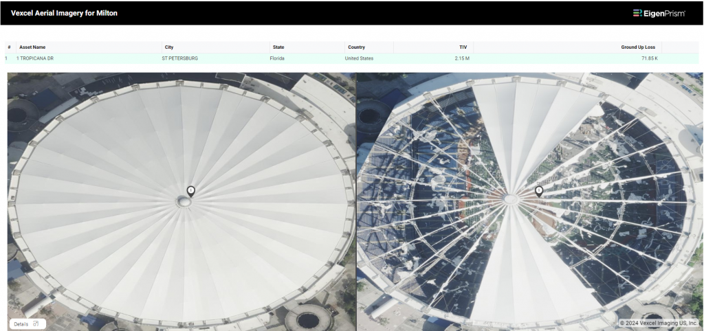
Subscribers of Vexcel in EigenPrism can access imagery associated with Milton.
NOAA Imagery
NOAA aerial imagery for Hurricane Milton is available in EigenPrism as WMS layers.
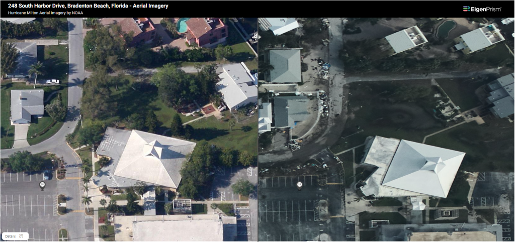
Here’s how you can access the WMS layers:
- On the analysis or report page, click the overlays button in the top right section of the map.
- Click “+Add an Overlay” and choose “Add a WMS layer”.
- Type Milton in the search box and choose the relevant layers.
Forecast
All EigenPrism® users can assess the forecast of the tropical cyclone using the following report template.
Hurricane Milton 2024 Forecast Impact Report Template
The report template auto-updates with the latest available footprints, which include:
- Hurricane Milton 5-day Forecast Maximum Winds by Adiabat
- Hurricane Milton Forecast Wind Swath by Hurricane Mapping
- Tropical-Storm-Force (greater than 34 kt) Wind Arrival Times by NOAA
- 5-day Tropical-Storm-Force (greater than 34 kt) Wind Probabilities by Hurricane Mapping
- 5-day Hurricane-Force (greater than 64 kt) Wind Probabilities by Wind Hurricane Mapping
- Hurricane Milton Storm Surge Potential by NOAA
- WPC 3-Day Excessive Rainfall Outlook from NWS
- US Flood Outlook from NWS
- NA 5-day Flood Potential from Adiabat
Subscribers of KatRisk can assess the wind, storm surge & flood forecast using the following report template:
Hurricane Milton KatRisk Forecast Report Template
This report template includes the following:
- Milton 2024 Max Wind Footprint as of Oct 09
- Milton 2024 Storm Surge footprint as of Oct 09
- Milton 2024 Inland Flood inundation footprint as of Oct 09
Oct 9 | Milton Regains Category 5 Strength, with Tampa Bay in the Bull’s Eye for a Direct Hit
Hurricane Milton is rapidly approaching Tampa Bay, where mass evacuations are already underway. Forecasters predict that the storm could bring a storm surge of up to 15 feet to the Tampa Bay area, which includes the cities of Tampa and St. Petersburg. For Tampa, this could be a rare, once-in-a-century direct hit. According to the U.S. Census Bureau, about 5.9 million people live in the 11 Florida counties currently under mandatory evacuation orders.
On Tuesday evening, Hurricane Milton regained its Category 5 strength, with sustained winds of 160 mph (260 kph). This comes just one day after it became one of the most powerful hurricanes ever recorded in the Atlantic basin. The storm is expected to make landfall on Wednesday night, threatening the Tampa Bay area, which has a population of over 3.3 million people.
Residents in the storm’s path are taking precautions by placing sandbags around properties, boarding up windows and doors, and moving boats to safer areas. Emergency orders, issued over the weekend, now cover 51 counties as the state braces for Milton’s impact.
Meteorologists are also warning of the potential for “several tornadoes,” including some that could be rated EF2 or higher. The Storm Prediction Center has indicated that the storm will likely trigger scattered thunderstorms and tornado clusters in the area to the west and north of Lake Okeechobee.
By Thursday, tropical storm conditions are expected to reach parts of the northwestern Bahamas, with possible impacts extending to the coasts of Georgia and South Carolina, according to the National Hurricane Center (NHC).
Florida Division of Emergency Management issued an evacuation map based on the current evacuation order for Florida Counties. You can click here to view the map.
Milton Regains Category 5 Strength Threatening Tampa Bay: Actionable Insights on EigenPrism
Forecast
All EigenPrism® users can assess the forecast of the tropical cyclone using the following report template.
Hurricane Milton 2024 Forecast Impact Report Template
The report template auto-updates with the latest available footprints, which include:
- Hurricane Milton 5-day Forecast Maximum Winds by Adiabat
- Hurricane Milton Forecast Wind Swath by Hurricane Mapping
- Tropical-Storm-Force (greater than 34 kt) Wind Arrival Times by NOAA
- 5-day Tropical-Storm-Force (greater than 34 kt) Wind Probabilities by Hurricane Mapping
- 5-day Hurricane-Force (greater than 64 kt) Wind Probabilities by Wind Hurricane Mapping
- Hurricane Milton Storm Surge Potential by NOAA
- WPC 3-Day Excessive Rainfall Outlook from NWS
- US Flood Outlook from NWS
- NA 5-day Flood Potential from Adiabat
All EigenPrism® users can assess the tornado outlook using the following footprint:
Significant Tornado Day 1 Outlook as of Oct 09 from NWS
NHC Tropical Cyclones WMS layer
EigenPrism users can also view the latest official NHC forecast track alongside event footprints using the Tropical Cyclones WMS layer.
Reask
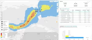
Subscribers of Reask can use these real-time footprints on EigenPrism® to quickly assess the wind impact:
Hurricane Milton 90th percentile wind speed footprints from Reask LiveCyc as of Oct 08, 2024
Hurricane Milton 50th percentile wind speed footprints from Reask LiveCyc as of Oct 08, 2024
Reask’s LiveCyc Scenarios
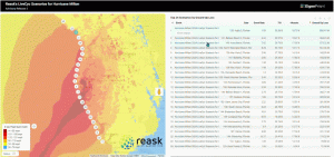
Reask subscribers in EigenPrism can use the LiveCyc ensemble scenarios for Milton to generate a range of potential loss estimates with more confidence.
Here’s how:
- Start an EigenRover Analysis and select your exposure dataset.
- When the Model Catalog opens automatically, open the event set‘Tropical Cyclone Forecast: Windspeed Footprint Ensembles from Reask LiveCyc’, type in ‘Milton’ in the search box, and choose the footprints for the latest release.
- Click ‘Run’ to generate loss estimates based on the different ensemble scenarios.
Post- Event
All EigenPrism users can assess the post-event impact of Hurricane Milton on the assets in the path it has taken so far using the following report template.
Hurricane Milton 2024 Post-Event Impact Report – Template
The report template auto-updates with the latest available footprints, which include:
- Hurricane Milton 2024 Past Max Winds by Adiabat
- Hurricane Milton Past Wind Swath – Advisory by Hurricane Mapping
Oct 08 | Hurricane Milton’s Explosive Intensification: From Category 1 to Category 5 in Just 24 Hours
Florida’s Gulf Coast is bracing for a life-threatening storm surge this week as Hurricane Milton approaches. Mandatory evacuations are already in place across the west coast of Florida, with millions of residents preparing for the storm’s devastating effects.
On Monday, Hurricane Milton intensified into a powerful Category 5 storm, packing winds of 180 mph. As of early Tuesday morning, the storm slightly weakened to Category 4, with sustained winds of 155 mph, down from 165 mph. However, the storm is forecasted to regain Category 5 strength and increase in size as it moves closer to land. Currently, the storm is located approximately 585 miles southwest of Tampa, Florida, moving east at 9 mph, according to the National Hurricane Center.
Although Milton briefly dipped into Category 4 status, forecasts predict it will regain Category 5 strength by Tuesday morning and maintain that intensity throughout the day. The storm is expected to fluctuate in strength but will likely make landfall as a Category 3 hurricane on Wednesday.
Hurricane Milton continues to be a powerful and potentially historic storm. With winds of 180 mph, it became the strongest Atlantic hurricane in the last five years, surpassing Hurricane Dorian in 2019. It also ranks as the fourth-strongest storm on record since monitoring began.
The storm surge forecast for Tampa Bay is particularly alarming, with predictions of up to 15 feet if the peak surge coincides with high tide. This is significantly higher than the surge seen during Hurricane Helene, which brought 7-8 feet of flooding to the area. A Hurricane Warning has been issued for Florida’s west coast from Bonita Beach to the mouth of the Suwannee River, including Tampa Bay.
Hurricane Milton’s Explosive Intensification: Actionable Insights on EigenPrism
Forecast
All EigenPrism® users can assess the forecast of the tropical cyclone using the following report template.
Hurricane Milton 2024 Forecast Impact Report Template
The report template auto-updates with the latest available footprints, which include:
- Hurricane Milton 5-day Forecast Maximum Winds by Adiabat
- Hurricane Milton Forecast Wind Swath by Hurricane Mapping
- Tropical-Storm-Force (greater than 34 kt) Wind Arrival Times by NOAA
- 5-day Tropical-Storm-Force (greater than 34 kt) Wind Probabilities by Hurricane Mapping
- 5-day Hurricane-Force (greater than 64 kt) Wind Probabilities by Wind Hurricane Mapping
- Hurricane Milton Storm Surge Potential by NOAA
- WPC 3-Day Excessive Rainfall Outlook from NWS
- US Flood Outlook from NWS
- NA 5-day Flood Potential from Adiabat
NHC Tropical Cyclones WMS layer
EigenPrism users can also view the latest official NHC forecast track alongside event footprints using the Tropical Cyclones WMS layer.
Reask
Subscribers of Reask can use this real-time footprint on EigenPrism® to quickly assess the impact of windspeed:
Hurricane Milton 90th percentile wind speed footprints from Reask LiveCyc as of Oct 07, 2024
Hurricane Milton 50th percentile wind speed footprints from Reask LiveCyc as of Oct 07, 2024
Reask’s LiveCyc Scenarios
Reask subscribers in EigenPrism can use the LiveCyc ensemble scenarios for Milton to generate a range of potential loss estimates with more confidence
Here’s how:
- Start an EigenRover Analysis and select your exposure dataset.
- When the Model Catalog opens automatically, open the event set‘Tropical Cyclone Forecast: Windspeed Footprint Ensembles from Reask LiveCyc’, type in ‘Milton’ in the search box, and choose the footprints for the latest release.
- Click ‘Run’ to generate loss estimates based on the different ensemble scenarios.
Post- Event
All EigenPrism users can assess the post-event impact of Hurricane Milton on the assets in the path it has taken so far using the following report template.
Hurricane Milton 2024 Post-Event Impact Report – Template
The report template auto-updates with the latest available footprints, which include:
- Hurricane Milton 2024 Past Max Winds by Adiabat
- Hurricane Milton Past Wind Swath – Advisory by Hurricane Mapping
Oct 07 | Hurricane Milton Races Toward Florida, Forecast to Intensify to Category 4 Before Landfall as Category 3
Less than two weeks after Hurricane Helene ravaged Florida, the state is now bracing for another potentially catastrophic storm, Hurricane Milton. A state of emergency has already been declared in several areas as Milton rapidly approaches the storm-battered Gulf Coast, threatening to deliver even more destruction. A Hurricane Watch is in effect for Florida’s Gulf Coast from Chokoloskee to the mouth of the Suwanee River, including Tampa Bay.
Tropical Storm Milton quickly strengthened into a Category 1 hurricane on Sunday, with its path aimed directly at Florida. The storm is forecasted to intensify to a Category 4 hurricane. According to federal forecasters, Milton is expected to make landfall on Wednesday evening on the Gulf Coast of Florida as a Category 3 hurricane with 120 mph winds.
As of the latest update from the National Hurricane Center, Hurricane Milton’s sustained winds have reached 90 mph and continue to intensify rapidly. The storm’s winds increased by 40 mph in just 15 hours, and further strengthening is expected over the next 48 hours.
Rainfall across the Florida Peninsula and the Keys is forecasted to range between 5 to 8 inches (127 to 203 mm), with some areas potentially receiving up to 12 inches (304 mm). This amount of rain could lead to flash flooding and minor-to-moderate river flooding, particularly along the state’s west coast, according to the NHC.
In addition, strong onshore winds along Florida’s Atlantic coast will pose a rip current threat throughout the weekend and into the early week. These dangerous rip currents can occur even without rainfall. Along the Gulf Coast, the risk of rip currents is expected to develop by early week, particularly in areas from Tampa southward.
Hurricane Milton Rapidly Intensifies, Expected to Reach Category 4: Actionable Insights on EigenPrism
All EigenPrism® users can assess the forecast of the tropical cyclone using the following report template.
Hurricane Milton 2024 Forecast Impact Report Template
The report template auto-updates with the latest available footprints, which include:
- Hurricane Milton 5-day Forecast Maximum Winds by Adiabat
- Hurricane Milton Forecast Wind Swath by Hurricane Mapping
- Tropical-Storm-Force (greater than 34 kt) Wind Arrival Times by NOAA
- 5-day Tropical-Storm-Force (greater than 34 kt) Wind Probabilities by Hurricane Mapping
- 5-day Hurricane-Force (greater than 64 kt) Wind Probabilities by Wind Hurricane Mapping
- Hurricane Milton Storm Surge Potential by NOAA
- WPC 3-Day Excessive Rainfall Outlook from NWS
- US Flood Outlook from NWS
- NA 5-day Flood Potential from Adiabat
Reask
Subscribers of Reask can use this real-time footprint on EigenPrism® to quickly assess the forecasted impact:
Hurricane Milton wind speed footprints from Reask LiveCyc as of Oct 07, 2024
Reask’s LiveCyc Scenarios
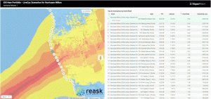
Reask subscribers in EigenPrism can use the LiveCyc ensemble scenarios for Milton to generate a range of potential loss estimates with more confidence
Here’s how:
1. Start an EigenRover Analysis and select your exposure dataset.
2. When the Model Catalog opens automatically, open the event set ‘Tropical Cyclone Forecast: Windspeed Footprint Ensembles from Reask LiveCyc’, type in ‘Milton’ in the search box, and choose the footprints for the latest release.
3. Click ‘Run’ to generate loss estimates based on the different ensemble scenarios.
Escape the News Cycle | Get Alerts Automatically For Events Impacting Your Assets
With EigenPrism Alerts, you can free yourself from constant event monitoring. Set up personalized alerts based on predefined impact thresholds and choose how you receive them – via email, SMS, or directly within EigenPrism. This way, you stay informed on your own terms, focusing only on the events that truly matter to your assets.
Set your alerts now.
Don’t have access to EigenPrism®?
Sign up for a trial account and access full impact reports of all events. Contact us, and we’ll set up a trial account for you.