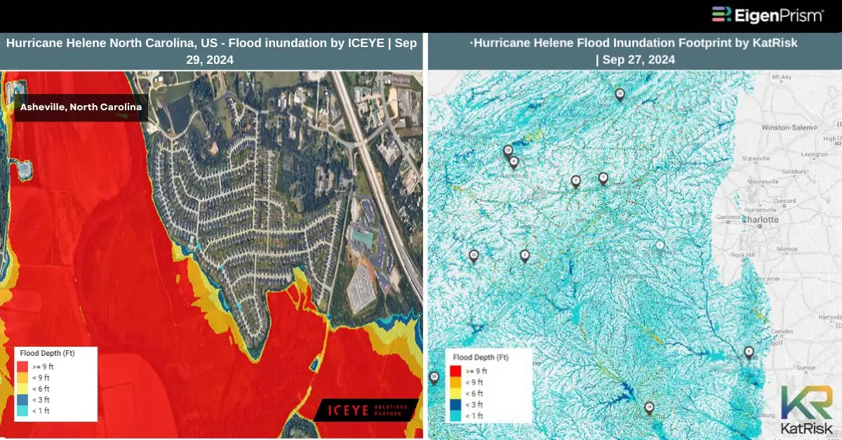
Hurricane Helene Tears Through North Carolina with Powerful Tornadoes, and Flooding
Hurricane Helene caused catastrophic flooding, powerful storm surge, and tornado damages, in multiple places leaving a devastating impact on many lives. The storm made landfall as a Category 4 hurricane in Florida’s Big Bend, prompting flash flood emergencies that stretched into Appalachia.
95 people have died because of Helene’s destructive path, with 30 fatalities in Buncombe County, North Carolina, according to CNN. The damage from the storm is estimated at between $95bn and $110bn (£71bn-£82bn) nationwide. The scale of the destruction will become clearer in the coming days.
As of Monday morning, more than 2 million homes and businesses were still without power, according to PowerOutage.us. Most of the fatalities occurred in North and South Carolina, where the storm weakened to a tropical storm but still brought deadly conditions. Helene initially began as a hurricane before moving north into Georgia, the Carolinas, and Tennessee.
The storm also spawned numerous tornadoes, with the majority occurring in the Carolinas. One particularly destructive tornado, which traveled the length of just five football fields, wreaked havoc in a North Carolina community along I-95 on Friday, destroying vehicles and heavily damaging buildings.
The strongest tornado spawned by Helene was an EF3 that struck Rocky Mount, North Carolina. Although Helene has significantly weakened, forecasters are still warning of high winds, continued flooding, and the potential for more tornadoes in affected areas.
Some parts of western North Carolina have been completely cut off by mudslides and flooding, forcing officials to airlift supplies, food, and water into these isolated communities. Across the Southeast, many towns and cities remain in recovery mode, grappling with significant damage to homes and infrastructure.
Florida’s Big Bend region, where Helene initially made landfall, was also among the hardest hit. Many residents returned to find their homes and roads washed away by storm surge flooding, with some coastal areas like Cedar Key enduring water levels 15 feet above ground. Meanwhile, cities such as Tampa and Clearwater Beach experienced their highest storm surge levels in decades.
Hurricane Helene Tears Through North Carolina: Actionable Insights on EigenPrism
Post- Event
All EigenPrism® users can assess the impact of the tropical cyclone using the following report template.
Hurricane Helene Post-Event Impact Template
The report template auto-updates with the latest available footprints, which include:
- Hurricane Helene 2024 Past Max Winds by Adiabat
- Hurricane Helene Past Wind Swath – Advisory by Hurricane Mapping
ICEYE
Subscribers of ICEYE can assess the impact of flooding using the following report template:
Hurricane Helene Post-Event Flood by ICEYE Impact Report Template
The report template auto-updates with the latest available footprints, which include:
- Hurricane Helene Southeast (USA) Florida 2024 – Flood Inundation
- Hurricane Helene Southeast (USA) North Carolina Tennessee 2024 – Flood Inundation
KatRisk
Subscribers of KatRisk can assess the impact of wind, storm surge & flood using the following report template:
Hurricane Helene 2024 by KatRisk Impact Report Template
The report template auto-updates with the latest available footprints, which include:
- Hurricane Helene Storm Surge Footprint by KatRisk
- Hurricane Helene Flood Inundation Footprint by KatRisk
- Hurricane Helene Wind Speed Footprint by KatRisk
Reask
Subscribers of Reask can use this real-time footprint on EigenPrism® to quickly assess the impact of windspeed:
Hurricane Helene Windspeed Intensity- Metryc Footprint as of Sep 28
Canopy Weather
Subscribers of Canopy Weather can use this real-time footprint on EigenPrism® to quickly assess the impact of tornadoes:
US Tornado Proximity Map as of Sep 28
Sep 27 | Helene Makes Catastrophic Landfall in Florida as Category 4 Hurricane, Currently a Tropical Storm over Georgia
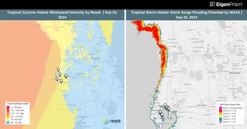 Hurricane Helene made landfall in Florida’s Big Bend region near Perry as a catastrophic storm, unleashing devastating winds exceeding 130 mph and threatening a potentially deadly storm surge of up to 20 feet, along with torrential rainfall.
Helene is now the strongest hurricane on record to strike Florida’s Big Bend, surpassing 2023’s Hurricane Idalia, which made landfall as a Category 3 storm with winds of 115 mph. Power outages have surged, with 1.3 million customers in Florida without electricity as of early Friday morning, as wind gusts in some areas reached or exceeded hurricane-force strength.
Waffle House had closed all its locations around Tallahassee and Crawfordville, about 18 miles south. In the southern United States, the closure of a Waffle House is often seen as a sign of a serious storm.
The hurricane came ashore with maximum sustained winds of 140 mph, landing just east of the mouth of the Aucilla River, about 10 miles west-southwest of Perry. The extreme winds prompted an “extreme wind warning” for several southern Georgia cities, including Valdosta, Thomasville, and Quitman.
Six states are now under states of emergency as Hurricane Helene ravages the Southeast after slamming into Florida as a Category 4 storm. While it has weakened to a tropical storm, the storm continues to bring torrential rain and damaging winds, causing widespread destruction to homes and infrastructure across the region.
Life-threatening flash and urban flooding, along with significant landslides, is expected to impact parts of the southern Appalachians through Friday. Northwestern and northern Florida, along with the Southeast, are likely to face severe to potentially catastrophic flash flooding. Widespread river flooding is also anticipated, with some areas possibly seeing major or even record-breaking levels
Helene Makes Catastrophic Landfall in Florida as Category 4 Hurricane: Actionable Insights on EigenPrism
Post- Event
All EigenPrism® users can assess the impact of the tropical cyclone using the following report template.
Hurricane Helene Post-Event Impact Template
The report template auto-updates with the latest available footprints, which include:
- Hurricane Helene 2024 Past Max Winds by Adiabat
- Hurricane Helene Past Wind Swath – Advisory by Hurricane Mapping
All EigenPrism® users can assess the forecast of the tropical cyclone using the following report template:
Tropical Cyclone Helene 2024 Forecast Impact Report template
The report template auto-updates with the latest available footprints, which include:
- Hurricane Helene Forecast Wind Swath by Hurricane Mapping
- Helene Forecast Maximum Winds by Adiabat
- Tropical-Storm-Force (greater than 34 kt) Wind Arrival Times by NOAA
- 5-day Tropical-Storm-Force (greater than 34 kt) Wind Probabilities by Hurricane Mapping
- 5-day Hurricane-Force (greater than 64 kt) Wind Probabilities by Wind Hurricane Mapping
- Tropical Cyclone Forecast Storm Surge by NOAA
All EigenPrism® users can access the forecast of the flooding using the following report template.
US Flood Forecast Report Template
The report template auto-updates with the latest available footprints, which include:
- WPC 3-Day Excessive Rainfall Outlook from NWS
- US Flood Outlook from NWS
- NA 3-day Flood Potential from Adiabat
- NA 5-day Flood Potential from Adiabat
Sep 26 | Hurricane Helene Strengthens, Bringing Deadly Storm Surge Threats to Florida
Helene is gaining strength as it approaches the U.S. Gulf Coast, having intensified into a Category 1 hurricane today. It is expected to make landfall in Florida’s Big Bend region late tomorrow. Forecasts predict that Helene will escalate to a powerful Category 4 hurricane before hitting the coast on Thursday, bringing with it a potentially devastating storm surge with up to 20 feet possible in some areas.
Nearly the entire state of Florida is under tropical weather alerts, with Tropical Storm Warnings extending far north into Georgia and the Carolinas, affecting major cities like Atlanta. A storm surge warning is also in effect for the Florida Keys and most of Florida’s west coast, warning of life-threatening flooding. As of the latest advisory, Helene is packing maximum sustained winds of 85 mph and is located about 425 miles southwest of Tampa, moving northward at 9 mph.
According to the National Hurricane Center (NHC), Helene is expected to intensify into a major hurricane, defined by sustained winds of at least 115 mph, as it nears the northeastern Gulf Coast on Thursday. The forecasted peak intensity of 130 mph would classify Helene as a Category 4 hurricane on the Saffir-Simpson Scale.
Once Helene makes landfall, it is expected to slow down and shift northwest, bringing widespread heavy rain, strong winds, and the potential for tornadoes across the Southeast through Friday and Saturday.
Tampa Bay is projected to experience storm surges of 5 to 8 feet, while Charlotte Harbor could see surges between 3 and 5 feet. Torrential rainfall from Helene is expected to cause significant flash and urban flooding across the Southeast, with rainfall totals ranging from 4 to 8 inches and isolated amounts reaching up to 12 inches. Additionally, there is a significant risk of river flooding across the region.
Hurricane Helene Strengthens, Bringing Deadly Storm Surge Threats to Florida: Actionable Insights on EigenPrism
Subscribers of Reask can use this real-time footprint on EigenPrism® to quickly assess the forecasted impact:
Tropical Cyclone wind speed footprint from Reask LiveCyc as on September 25
All EigenPrism® users can assess the forecast of the tropical cyclone using the following report template:
Tropical Cyclone Helene 2024 Forecast Impact Report template
The report template auto-updates with the latest available footprints, which include:
- Hurricane Helene Forecast Wind Swath by Hurricane Mapping
- Helene Forecast Maximum Winds by Adiabat
- Tropical-Storm-Force (greater than 34 kt) Wind Arrival Times by NOAA
- 5-day Tropical-Storm-Force (greater than 34 kt) Wind Probabilities by Hurricane Mapping
- 5-day Hurricane-Force (greater than 64 kt) Wind Probabilities by Wind Hurricane Mapping
- Tropical Cyclone Forecast Storm Surge by NOAA
All EigenPrism® users can access the forecast of the flooding using the following report template.
US Flood Forecast Report Template
The report template auto-updates with the latest available footprints, which include:
- WPC 3-Day Excessive Rainfall Outlook from NWS
- US Flood Outlook from NWS
- NA 3-day Flood Potential from Adiabat
- NA 5-day Flood Potential from Adiabat
Subscribers of Reask in EigenPrism can also use LiveCyc ensemble footprints for Helene.
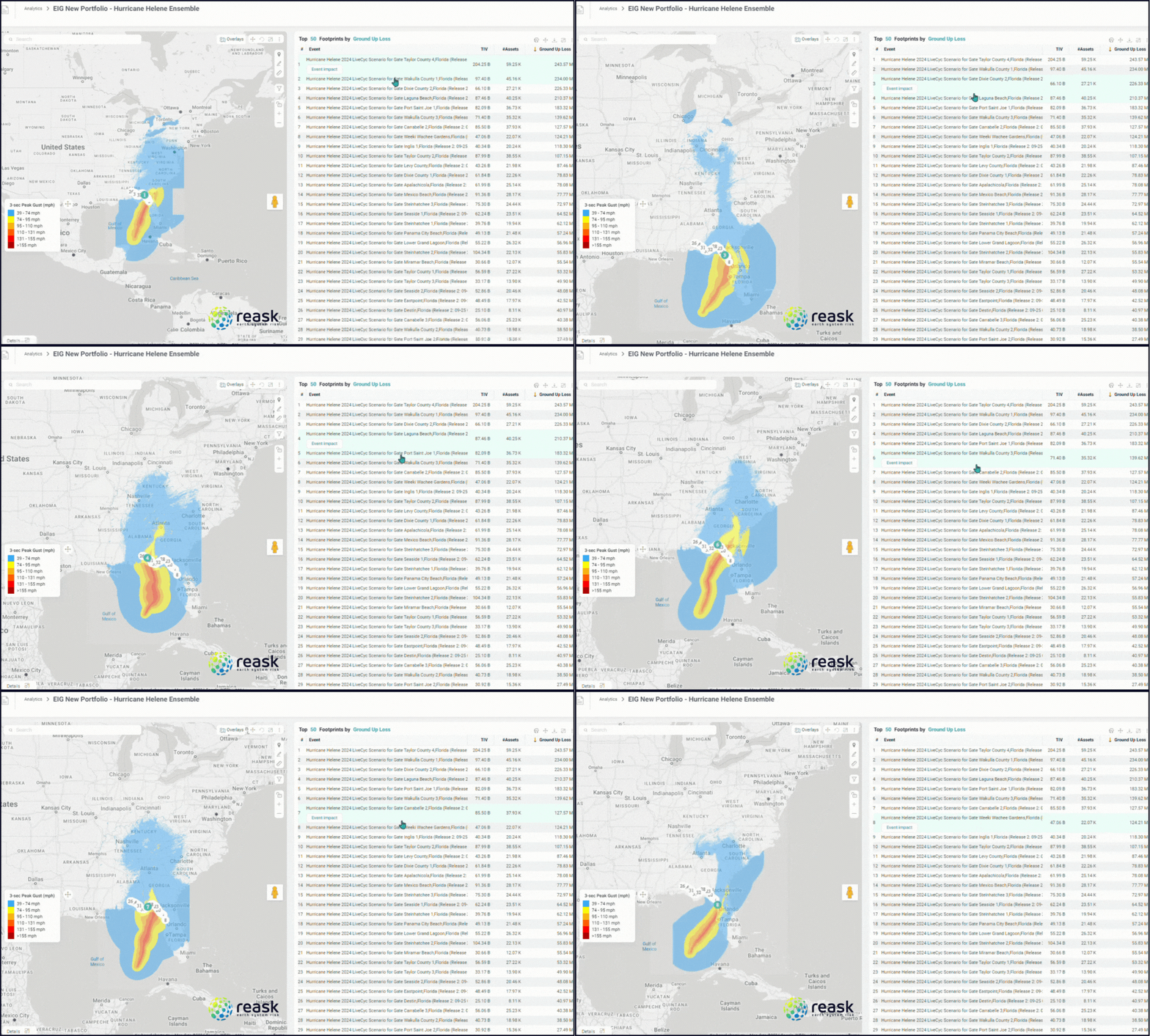
To view multiple scenarios at once, you can run Eigen Rover.
Here’s how:
- Start an EigenRover Analysis and select your exposure dataset.
- When the Model Catalog opens automatically, choose the relevant events in the “Tropical Cyclone Forecast: Windspeed Footprint Ensembles from Reask LiveCyc” event set. You can type in the release number in the search box to further filter the footprints.
- Click “Run” to generate loss estimates based on the different ensemble scenarios. For more information on the scenarios, you can add additional columns like the event rate and gate to the table by clicking on the ellipsis of the table and choosing the fields.
Sep 24 | Potential Tropical Cyclone Nine Set to Strengthen, Threatening the U.S. Gulf Coast with Flooding and Storm Surge
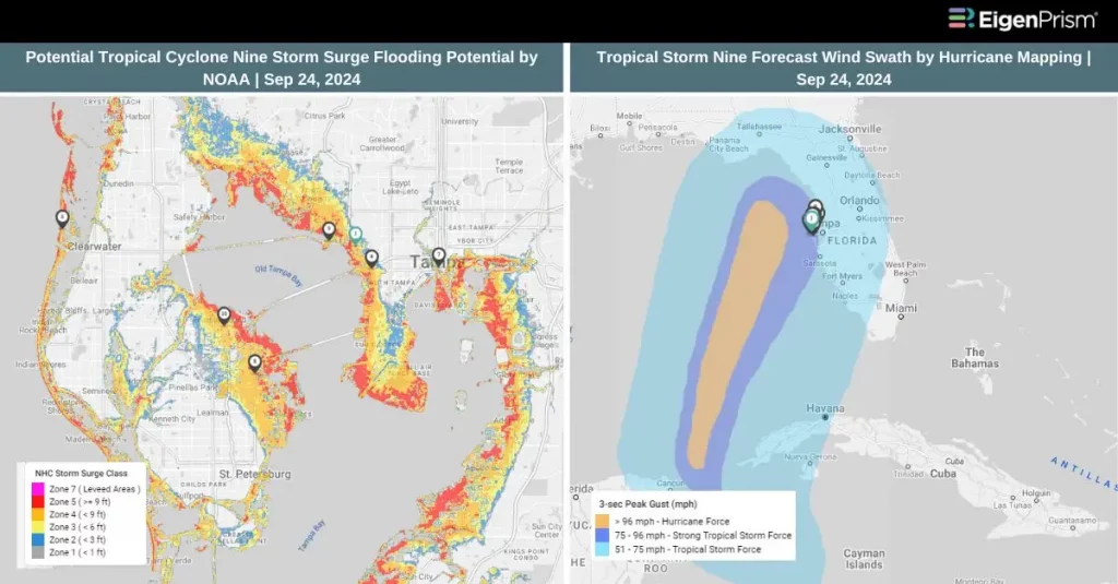 Florida is preparing for what could become the most powerful hurricane to hit the United States this season as a developing system of thunderstorms in the Caribbean Sea gains strength. If the storm continues to intensify, it could bring life-threatening storm surges and hurricane-force winds to the southeastern U.S. later this week.
Currently identified as Potential Tropical Cyclone Nine, the system will be named Helene if it reaches tropical storm status. As of the latest advisory from the National Hurricane Center (NHC), the storm is located 105 miles southwest of Grand Cayman and 315 miles southeast of the western tip of Cuba, with maximum sustained winds of 35 mph. It is moving north-northwest at 7 mph.
The system is expected to bring heavy rainfall, with 4 to 12 inches forecasted for western Cuba and the Cayman Islands, and 2 to 6 inches for the eastern Yucatán Peninsula, posing risks of flash flooding and urban flooding. In Florida, storm surge could rise between 1 to 3 feet, particularly affecting the Dry Tortugas and the Florida Keys.
The disturbance is projected to strengthen into a hurricane by Wednesday and continue intensifying as it moves through the eastern Gulf of Mexico. Strong winds, storm surges, and significant damage are anticipated near its eventual landfall. Additionally, the system is likely to cause rough seas, hazardous surf, and dangerous rip currents throughout the Gulf later in the week.
As the storm system continues to organize, it will bring potentially flooding rains to parts of Central America, Mexico, Cuba, and Jamaica. Hurricane and tropical storm watches have already been issued for areas in Mexico and Cuba. By Friday, Helene could bring strong winds and heavy rainfall to Georgia and the Carolinas, potentially resulting in dangerous flooding and widespread power outages.
Potential Tropical Cyclone Nine Set to Strengthen, Threatening the U.S. Gulf Coast: Actionable Insights on EigenPrism
All EigenPrism® users can assess the forecast of the tropical cyclone using the following report template.
Tropical Cyclone Helene 2024 Forecast Impact Report
The report template auto-updates with the latest available footprints, which include:
- TropStorm Nine Forecast Wind Swath – Advisory 04 by Hurricane Mapping
- Tropical-Storm-Force (greater than 34 kt) Wind Arrival Times by NOAA
- 5-day Tropical-Storm-Force (greater than 34 kt) Wind Probabilities by Hurricane Mapping
- 5-day Hurricane-Force (greater than 64 kt) Wind Probabilities by Wind Hurricane Mapping
- Tropical Cyclone Forecast Storm Surge by NOAA
All EigenPrism® users can assess the forecast of the flooding using the following report template.
US Flood Forecast Report Template
The report template auto-updates with the latest available footprints, which include:
- WPC 3-Day Excessive Rainfall Outlook from NWS
- US Flood Outlook from NWS
- NA 3-day Flood Potential from Adiabat
- NA 5-day Flood Potential from Adiabat
Escape the News Cycle | Get Alerts Automatically For Events Impacting Your Assets
With EigenPrism Alerts, you can free yourself from constant event monitoring. Set up personalized alerts based on predefined impact thresholds and choose how you receive them – via email, SMS, or directly within EigenPrism. This way, you stay informed on your own terms, focusing only on the events that truly matter to your assets.
Set your alerts now.
Don’t have access to EigenPrism®?
Sign up for a trial account and access full impact reports of all events. Contact us, and we’ll set up a trial account for you.