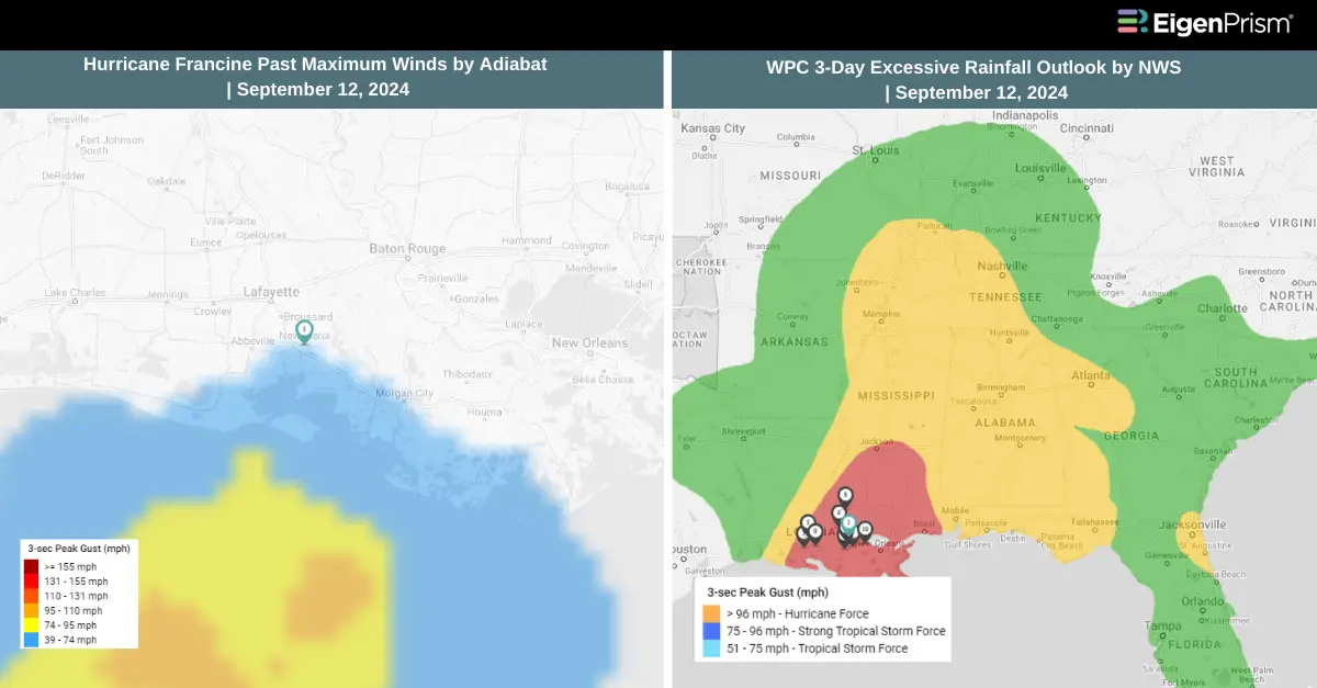
Francine Makes Landfall as Category 2 Hurricane in Louisiana
Hurricane Francine has caused widespread power outages and severe flooding after making landfall on the Louisiana coast and moving further inland. The storm struck Morgan City as a Category 2 hurricane on Wednesday, bringing sustained winds of 100 mph, according to the National Hurricane Center (NHC).
A flash flooding emergency was declared in New Orleans after the city received between six and eight inches (15-20 cm) of rain. While Francine has since weakened to a tropical storm, it maintained winds of up to 70 mph as it moved northwest of New Orleans late Wednesday, the NHC reported. During the storm’s passage, New Orleans recorded wind gusts of 78 and 76 mph, while Dulac reported a peak gust of 97 mph.
The number of power outages across Louisiana continued to rise, with over 300,000 customers without electricity by Wednesday evening, according to PowerOutage.us.
Both Louisiana and neighboring Mississippi have declared states of emergency, urging residents to take shelter and prepare for the storm’s impact. Although Francine is expected to “rapidly” lose strength as it moves further across the state, it has already caused significant damage and disruption.
Francine Makes Landfall as Category 2 Hurricane in Louisiana: Actionable Insights on EigenPrism
Post- Event
All EigenPrism® users can assess the impact of the tropical cyclone using the following report template.
Hurricane Francine Post-Event Impact Report
The report template auto-updates with the latest available footprints, which include:
- Hurricane Francine 2024 Past Max Winds by Adiabat
- Hurricane Francine Past Wind Swath – Advisory by Hurricane Mapping
All EigenPrism® users can assess the forecast of the tropical cyclone using the following report template.
Tropical Cyclone Francine 2024 Forecast Impact Report
The report template auto-updates with the latest available footprints, which include:
- Tropical Storm Francine Forecast Wind Swath – Advisory 07 by Hurricane Mapping
- Tropical-Storm-Force (greater than 34 kt) Wind Arrival Times by NOAA
- 5-day Tropical-Storm-Force (greater than 34 kt) Wind Probabilities by Hurricane Mapping
- 5-day Hurricane-Force (greater than 64 kt) Wind Probabilities by Wind Hurricane Mapping
- Tropical Cyclone Francine Forecast Storm Surge by NOAA
All EigenPrism® users can assess the forecast of the flooding using the following report template.
US Flood Forecast Report Template
The report template auto-updates with the latest available footprints, which include:
- WPC 3-Day Excessive Rainfall Outlook from NWS
- US Flood Outlook from NWS
- NA 3-day Flood Potential from Adiabat
- NA 5-day Flood Potential from Adiabat
Sep 11 | Francine Strengthens to Category 1 Hurricane, Threatening Louisiana with Devastating Storm Surge and Flooding
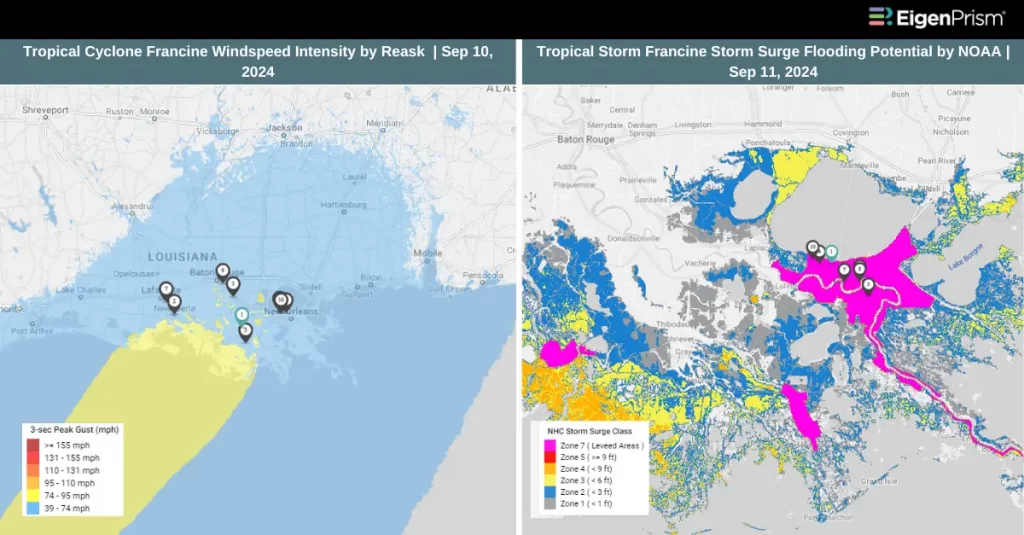 Hurricane Francine has intensified into a Category 1 hurricane, with maximum sustained winds of 75 mph, and is expected to continue strengthening as it approaches the Louisiana coast on Wednesday. The storm poses a severe threat to the U.S. Gulf Coast, with significant flooding, dangerous storm surge, and damaging winds anticipated.
As of early Wednesday, Francine was approximately 275 miles from Morgan City, Louisiana, according to the National Hurricane Center. A hurricane watch has been issued for the New Orleans area due to a slight eastward shift in the forecasted track.
Forecasters predict that the hurricane will continue to intensify over the warm waters of the Gulf of Mexico through Wednesday morning and make landfall by Wednesday afternoon or evening. Louisiana is expected to face the most severe impacts, including up to 10 inches of rain, damaging hurricane-force winds, and a life-threatening storm surge that could reach up to 10 feet along the coast.
Parts of Louisiana could receive up to 12 inches of rain, with New Orleans expected to be among the hardest-hit areas. Storm surges along the Louisiana coast could reach up to 10 feet, with 2 to 5 feet of surges possible in the New Orleans area. Baton Rouge is currently under a hurricane warning. Meanwhile, the Texas coast is already experiencing heavy rain and strong winds as the storm moves closer.
The primary threat for Louisiana and Mississippi on Wednesday and Wednesday night will be flash flooding, as torrential rains inundate the region. By Thursday, the risk of heavy flooding will extend further north into Arkansas, Tennessee, Missouri, and Kentucky as Francine continues its path inland.
Francine Strengthens to Category 1 Hurricane: Actionable Insights on EigenPrism
Post- Event
All EigenPrism® users can assess the impact of the tropical cyclone using the following report template.
Hurricane Francine Post-Event Impact Report
The report template auto-updates with the latest available footprints, which include:
- Hurricane Francine 2024 Past Max Winds by Adiabat
- Hurricane Francine Past Wind Swath – Advisory by Hurricane Mapping
Forecast
Subscribers of Reask can use this real-time footprint on EigenPrism® to quickly assess the forecasted impact:
Tropical Cyclone wind speed footprint from Reask LiveCyc as on September 10
All EigenPrism® users can assess the forecast of the tropical cyclone using the following report template.
Tropical Cyclone Francine 2024 Forecast Impact Report
The report template auto-updates with the latest available footprints, which include:
- Tropical Storm Francine Forecast Wind Swath – Advisory 07 by Hurricane Mapping
- Tropical-Storm-Force (greater than 34 kt) Wind Arrival Times by NOAA
- 5-day Tropical-Storm-Force (greater than 34 kt) Wind Probabilities by Hurricane Mapping
- 5-day Hurricane-Force (greater than 64 kt) Wind Probabilities by Wind Hurricane Mapping
- Tropical Cyclone Francine Forecast Storm Surge by NOAA
All EigenPrism® users can assess the forecast of the flooding using the following report template.
US Flood Forecast Report Template
The report template auto-updates with the latest available footprints, which include:
- WPC 3-Day Excessive Rainfall Outlook from NWS
- US Flood Outlook from NWS
- NA 3-day Flood Potential from Adiabat
- NA 5-day Flood Potential from Adiabat
Sep 10 | Tropical Storm Francine Set to Intensify into a Hurricane, Threatening Texas and Louisiana Coastlines
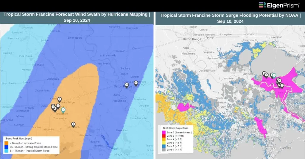
Potential Tropical Cyclone Six was upgraded to Tropical Storm Francine on Monday morning and is forecasted to intensify into a hurricane well before reaching the Louisiana coast on Wednesday. The storm can reach hurricane status by Tuesday and may further strengthen to a Category 2 hurricane by the time it makes landfall. As of early Tuesday, Francine was located about 125 miles from the Texas-Mexico border, with maximum sustained winds of 65 mph—just 9 mph shy of hurricane strength, according to the National Hurricane Center.
Francine poses a significant threat to the upper Texas and Louisiana coastlines with heavy rainfall, damaging winds, and potentially life-threatening storm surges as it moves through. The most severe impacts are expected in southern Louisiana around the time of landfall.
Currently, over 5 million people along the Gulf Coast are under flood watches. Rainfall amounts are expected to range from 4 to 8 inches from the northeastern coast of Mexico to southern Mississippi, with some areas potentially receiving up to 12 inches.
Alongside a hurricane warning in Louisiana, tropical storm warnings and watches have been issued for parts of the Louisiana and Texas coasts. A storm surge warning is also in effect from High Island, Texas, to the mouth of the Mississippi River, highlighting the risk of coastal flooding.
While Francine is forecasted to weaken quickly after moving inland on Wednesday, it is still expected to bring heavy rainfall to parts of the lower and middle Mississippi River Valley throughout the week.
Tropical Storm Francine Set to Intensify into a Hurricane: Actionable Insights on EigenPrism
Subscribers of Reask can use this real-time footprint on EigenPrism® to quickly assess the forecasted impact:
Tropical Cyclone wind speed footprint from Reask LiveCyc as on September 09
All EigenPrism® users can assess the forecast of the tropical cyclone using the following report template.
Tropical Cyclone Francine 2024 Forecast Impact Report
The report template auto-updates with the latest available footprints, which include:
- Tropical Storm Francine Forecast Wind Swath – Advisory 07 by Hurricane Mapping
- Tropical-Storm-Force (greater than 34 kt) Wind Arrival Times by NOAA
- 5-day Tropical-Storm-Force (greater than 34 kt) Wind Probabilities by Hurricane Mapping
- 5-day Hurricane-Force (greater than 64 kt) Wind Probabilities by Wind Hurricane Mapping
- Tropical Cyclone Francine Forecast Storm Surge by NOAA
All EigenPrism® users can assess the forecast of the flooding using the following report template.
US Flood Forecast Report Template
The report template auto-updates with the latest available footprints, which include:
- WPC 3-Day Excessive Rainfall Outlook from NWS
- US Flood Outlook from NWS
- NA 3-day Flood Potential from Adiabat
- NA 5-day Flood Potential from Adiabat
Sep 09 | Potential Tropical Cyclone Six Forms in Gulf, Forecasted to Track Toward Texas and Louisiana by Wednesday
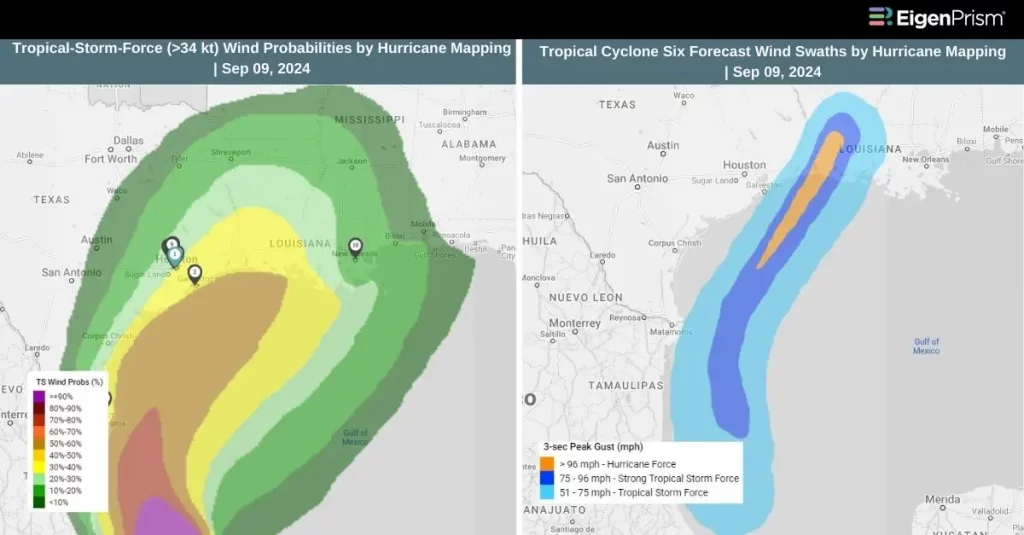
Potential Tropical Cyclone Six has developed over the Gulf of Mexico, prompting the National Hurricane Center (NHC) to issue tropical storm watches for parts of Mexico. The system is to strengthen into a tropical storm by Monday as it moves northward along the western Gulf coast. Further intensification can happen on Tuesday and could develop into a hurricane before reaching the northwestern Gulf Coast by midweek.
The next Atlantic named storm would be called Francine.
The NHC has indicated that additional watches or warnings may be issued for sections of the Texas and Louisiana coastlines later on Sunday night or Monday. As of the latest update, the system was positioned about 320 miles south of the mouth of the Rio Grande, with maximum sustained winds of 50 mph. It is currently moving northwest at a speed of 5 mph.
The NHC warns that Potential Tropical Cyclone Six could bring heavy rainfall and a significant risk of flash flooding from northeastern Mexico to parts of coastal Texas and Louisiana through Thursday. Rainfall totals are expected to range from 4 to 8 inches, with some areas potentially receiving up to 12 inches. Additionally, minor coastal flooding is anticipated along Mexico’s coastline.
Potential Tropical Cyclone Six Forms in the Gulf: Actionable Insights on EigenPrism
All EigenPrism® users can assess the forecast of the tropical cyclone using the following report template.
Tropical Cyclone Six 2024 Forecast Impact Report
The report template auto-updates with the latest available footprints, which include:
- Tropical Cyclone Six Forecast Wind Swath – Advisory 07 by Hurricane Mapping
- Tropical-Storm-Force (greater than 34 kt) Wind Arrival Times by NOAA
- 5-day Tropical-Storm-Force (greater than 34 kt) Wind Probabilities by Hurricane Mapping
- 5-day Hurricane-Force (greater than 64 kt) Wind Probabilities by Wind Hurricane Mapping
- Tropical Cyclone Forecast Storm Surge by NOAA
All EigenPrism® users can assess the forecast of the flooding using the following report template.
US Flood Forecast Report Template
The report template auto-updates with the latest available footprints, which include:
- WPC 3-Day Excessive Rainfall Outlook from NWS
- US Flood Outlook from NWS
- NA 3-day Flood Potential from Adiabat
- NA 5-day Flood Potential from Adiabat
Escape the News Cycle | Get Alerts Automatically For Events Impacting Your Assets
With EigenPrism Alerts, you can set Alerts and free yourself from constant event monitoring. Set up personalized alerts based on predefined impact thresholds and choose how you receive them – via email, SMS, or directly within EigenPrism. This way, you stay informed on your own terms, focusing only on the events that truly matter to your assets.
Set your alerts now.
Don’t have access to EigenPrism®?
Sign up for a trial account and access full impact reports of all events. Contact us, and we’ll set up a trial account for you.