Tropical Storm Debby’s Destructive Journey Across Eastern US
Hurricane Debby may have exited the U.S. over the weekend, but the destruction. It left behind continues to affect thousands. Debby, a slow-moving and unpredictable Category 1 hurricane, brought widespread flooding across the Southeastern United States. The storm was officially named Debby when its sustained wind speeds reached 39 mph, marking it as a tropical storm. As the winds intensified to 74 mph, Debby was classified as a hurricane.
On August 5, Hurricane Debby made landfall near Steinhatchee, Florida, in the state’s Big Bend region. Although it quickly weakened to a tropical storm after moving inland, Debby still caused significant damage, resulting in four fatalities. The storm’s slow pace unleashed heavy rain and severe flooding across Florida, rescuing hundreds of stranded residents. After crossing the state, Tropical Storm Debby moved into the Atlantic before making a second landfall, continuing her destructive journey toward the Eastern U.S.
Despite being categorized as a Category 1 hurricane, Debby’s slow movement across Florida and itspath through Georgia and the Carolinas brought days of relentless rainfall. The storm’s impact included severe flooding and several tornadoes. Debby’s outer bands began impacting Central and South Florida as early as August 3, bringing gusty winds and heavy rainfall. Multiple tornado warnings were issued across the state, and as Debby made landfall, nearly 250,000 power outages were reported.
In coastal Georgia, residents were placed under storm surge and tropical storm warnings, with around 47,000 customers losing power. South Carolina experienced seven confirmed tornadoes, four of which were rated EF1, while the remaining three were rated EF0. Flash flood alerts extended into Westfield, Pennsylvania as well.
As Debby continued to weaken and moved inland on August 10, parts of New England’s coastal region faced dangerous rip currents and large swells. The National Weather Service issued rip current statements for the entire coastlines of Maine, Massachusetts, New Hampshire, and Rhode Island, highlighting the ongoing threats posed by Debby even after she had passed.
Debby’s Destructive Journey Across Eastern US: Actionable Insights on EigenPrism
Post-Event
Subscribers of ICEYE can use this real-time footprint on EigenPrism® to quickly assess the impact of flooding:
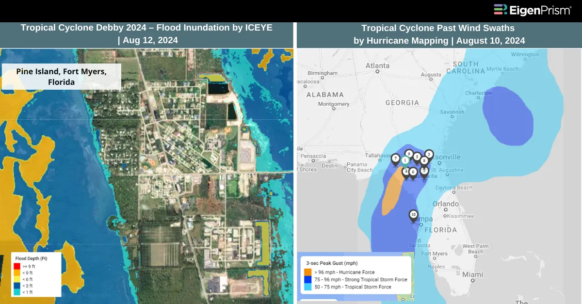
Tropical Cyclone Debby 2024 – Flood Inundation footprint from ICEYE as of August 12
Subscribers of KatRisk can assess the post-event impact of the tropical cyclone using the following report template.
Hurricane Debby 2024 KatRisk Post-Event Impact Report
The report template auto-updates with the latest available footprints, which include:
- Debby 2024 Inland Flood inundation by KatRisk
- Debby 2024 Max Wind Footprint by KatRisk
- Debby 2024 Storm Surge Footprint by KatRisk
All EigenPrism® users can assess the impact of the tropical cyclone using the following report template.
Hurricane Debby 2024 Post-Event Impact Report
The report template auto-updates with the latest available footprints, which include:
- Hurricane Debby 2024 Past Max Winds by Adiabat
- Hurricane Debby Past Wind Swath – Advisory by Hurricane Mapping
- Damage Survey Footprints of 20 Tornadoes Between Aug 07- Aug 09, 2024 from NWS Potentially Triggered by Tropical Storm Debby
Aug 09 | Debby Now Extends Flooding and Tornado Threats Across the Eastern US
As Debby raced northward toward the Northeast on Friday, its heavy rains, flooding, and tornado threats extended across hundreds of miles of the eastern United States. Although Debby lost its tropical storm status on Friday morning, it remains a powerful storm, triggering tornado and flood warnings in Washington, DC, and causing a flash flood emergency with water rescues in South Carolina.
Flood warnings and watches are in effect from the Carolinas to New England. The National Weather Service reported early Friday that rainfall in some areas had reached 15 to 25 inches. Over 40 million people are currently under some level of flood alert, covering more than 900 miles from Georgia to New York and northern New England.
Although rainfall totals on Friday will be lower than earlier in the week—when Debby dropped more than a foot of rain in parts of the Southeast—the Northeast faces a significant flood threat, especially in high-terrain areas. This threat is exacerbated by already saturated ground from a previous flooding event earlier in the week.
A tornado watch is in effect until 2 p.m. EDT for over 26.1 million people across Virginia, Maryland, Delaware, Pennsylvania, New Jersey, and New York, including major cities like Washington, DC, Baltimore, and Philadelphia, according to the Storm Prediction Center.
Debby Now Extends Flooding and Tornado Threats Across the Eastern US: Actionable Insights on EigenPrism
Post-Event
Subscribers of ICEYE can use this real-time footprint on EigenPrism® to quickly assess the impact of flooding:
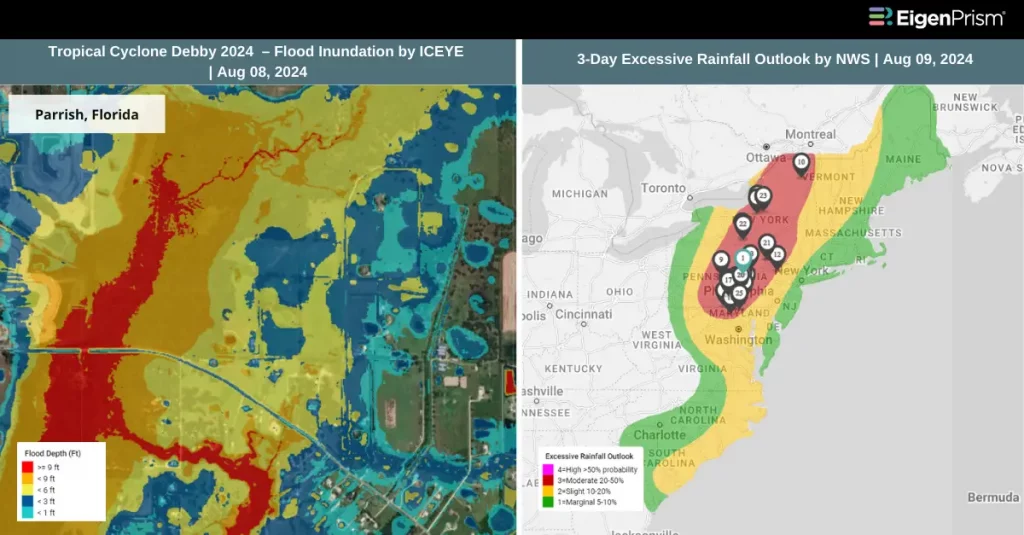
Tropical Cyclone Debby 2024 – Flood Inundation footprint from ICEYE as of August 08
Subscribers of KatRisk can assess the post-event impact of the tropical cyclone using the following report template.
Hurricane Debby 2024 KatRisk Post-Event Impact Report
The report template auto-updates with the latest available footprints, which include:
- Debby 2024 Inland Flood inundation by KatRisk
- Debby 2024 Max Wind Footprint by KatRisk
- Debby 2024 Storm Surge Footprint by KatRisk
All EigenPrism® users can assess the impact of the tropical cyclone using the following report template.
Hurricane Debby 2024 Post-Event Impact Report
The report template auto-updates with the latest available footprints, which include:
- Hurricane Debby 2024 Past Max Winds by Adiabat
- Hurricane Debby Past Wind Swath – Advisory by Hurricane Mapping
Forecast
Tropical Cyclone Debby 2024 Forecast Impact Report
The report template auto-updates with the latest available footprints, which include:
- Tropical-Storm-Force (greater than 34 kt) Wind Arrival Times by NOAA
- Tropical Cyclone Forecast: Wind Swaths by Hurricane Mapping
- Tropical Cyclone Forecast: Maximum Winds by Adiabat
- 5-day Tropical-Storm-Force (greater than 34 kt) Wind Probabilities by Hurricane Mapping
- 5-day Hurricane-Force (greater than 64 kt) Wind Probabilities by Wind Hurricane Mapping
Aug 08 | Tropical Storm Debby Makes Landfall in South Carolina, Bringing Torrential Rains
 Tropical Storm Debby made a second landfall in the U.S. early Thursday, dumping more than a foot of rain and threatening more severe weather. The storm is expected to bring additional torrential rains, tornadoes, and destructive flooding as it moves northward through the week.
Debby made landfall near Bulls Bay, South Carolina, about 20 miles northeast of Charleston, with maximum sustained winds of 50 mph. The storm is moving inland slowly at 5 mph, according to the National Hurricane Center.
It is expected to move into North Carolina by Thursday evening and northern Virginia by Friday morning. The storm will then accelerate through Pennsylvania by Friday evening and reach New England by Saturday morning, bringing heavy rains and flash flooding to areas already drenched by storms earlier this week.
Tropical Storm Warnings remain in effect for the South Carolina and southeastern North Carolina coasts. Winds will gradually increase through the day, with gusts of 40-60 mph expected, particularly from Myrtle Beach through Cape Fear, North Carolina.
A tornado watch has been issued for eastern North Carolina. Rainfall totals could reach up to 15 inches in North Carolina, with South Carolina seeing up to 25 inches. Dangerous rip currents and storm surges of up to 3 feet are possible along the coasts of the Carolinas.
In Bulloch County, Georgia, a dam is in danger of “imminent failure” due to Debby’s torrential rainfall, according to the National Weather Service in Charleston, South Carolina. A few tornadoes are also likely along and east of Interstate 95 in North Carolina and southeastern Virginia.
Tropical Storm Debby Makes Landfall in South Carolina, Bringing Torrential Rains: Actionable Insights on EigenPrism
Post-Event
Subscribers of ICEYE can use this real-time footprint on EigenPrism® to quickly assess the impact of flooding:
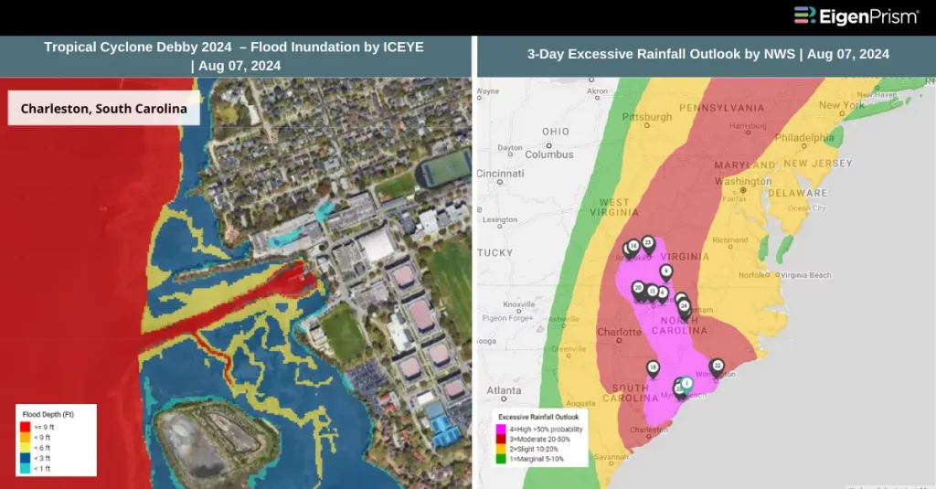
Tropical Cyclone Debby 2024 – Flood Inundation footprint from ICEYE as of August 07
Subscribers of KatRisk can assess the post-event impact of the tropical cyclone using the following report template.
Hurricane Debby 2024 KatRisk Post-Event Impact Report
The report template auto-updates with the latest available footprints, which include:
- Debby 2024 Inland Flood inundation by KatRisk
- Debby 2024 Max Wind Footprint by KatRisk
- Debby 2024 Storm Surge Footprint by KatRisk
All EigenPrism® users can assess the impact of the tropical cyclone using the following report template.
Hurricane Debby 2024 Post-Event Impact Report
The report template auto-updates with the latest available footprints, which include:
- Hurricane Debby 2024 Past Max Winds by Adiabat
- Hurricane Debby Past Wind Swath – Advisory by Hurricane Mapping
Forecast
Subscribers of Reask can use this real-time footprint on EigenPrism® to quickly assess the impact:
Tropical Cyclone wind speed footprint from Reask LiveCyc as on August 06
All EigenPrism® users can assess the forecast of the tropical cyclone using the following report template.
Tropical Cyclone 2024 Forecast Impact Report (2024)
The report template auto-updates with the latest available footprints, which include:
- Tropical-Storm-Force (greater than 34 kt) Wind Arrival Times by NOAA
- Tropical Cyclone Forecast: Wind Swaths by Hurricane Mapping
- Tropical Cyclone Forecast: Maximum Winds by Adiabat
- 5-day Tropical-Storm-Force (greater than 34 kt) Wind Probabilities by Hurricane Mapping
- 5-day Hurricane-Force (greater than 64 kt) Wind Probabilities by Wind Hurricane Mapping
- 3-Day Excessive Rainfall Outlook by NWS
- 5-day Flood Potential by Adiabat
- 3-day Flood Potential by Adiabat
- Tropical Cyclone Forecast: Storm Surge Flooding Potential by NOAA
Aug 07 | Tropical Storm Debby Moves Toward Georgia and South Carolina, Likely to Strengthen
 Tropical Storm Debby is causing significant disruption along the East Coast, bringing torrential rains and dangerous flooding to South Carolina while contributing to another major flood threat in the Northeast.
Hurricane Debby made landfall in Steinhatchee, a town in Florida’s Big Bend region on August 05 (Monday). Parts of Southwest Florida, including Naples, Bonita Beach, and Sarasota, were flooded by the tropical storm.
Currently moving slowly offshore toward the waters off Georgia and South Carolina, Debby is expected to strengthen before making a second landfall later this week. The storm is producing sustained winds of 40 mph, extending up to 205 miles from its center.
Debby is forecasted to linger in the Atlantic until it makes landfall again between Charleston and Myrtle Beach, South Carolina, on Thursday. In the meantime, it will continue to batter the state with heavy rain, severe flooding, and occasional tornadoes. A tornado watch along the Carolinas coastline has been extended until 1 a.m. Wednesday.
The NOAA Weather Prediction Center has issued a Level 4 flood risk, the highest threat level, for parts of southeastern Georgia, eastern South Carolina, and southeastern North Carolina on Wednesday and Thursday. Storm surges of 2 to 4 feet are possible from the South Santee River, South Carolina, to Cape Fear, North Carolina, with up to 25 inches of rain expected in some areas of the Carolinas through Friday.
Debby is likely to strengthen as it hovers over the warm Atlantic waters, though its proximity to land should prevent it from regaining hurricane strength. After making landfall again in the Southeast, Debby is expected to move up the entire East Coast starting Friday. The storm is anticipated to weaken to a tropical depression by Saturday morning and remain at that strength as it reaches Maine by Sunday.
Tropical Storm Debby Moves Toward Georgia and South Carolina, Likely to Strengthen: Actionable Insights on EigenPrism
Post-Event
Subscribers of ICEYE can use this real-time footprint on EigenPrism® to quickly assess the impact of flooding:
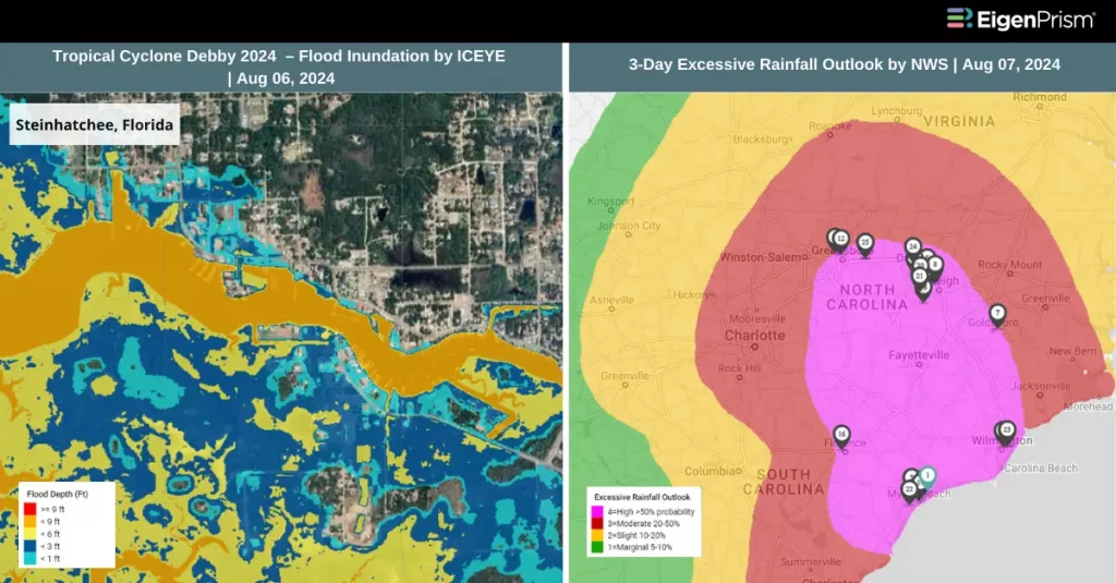
Tropical Cyclone Debby 2024 – Flood Inundation footprint from ICEYE as of August 06
Subscribers of KatRisk can assess the post-event impact of the tropical cyclone using the following report template.
Hurricane Debby 2024 KatRisk Post-Event Impact Report
The report template auto-updates with the latest available footprints, which include:
- Debby 2024 Inland Flood inundation by KatRisk
- Debby 2024 Max Wind Footprint by KatRisk
- Debby 2024 Storm Surge Footprint by KatRisk
All EigenPrism® users can assess the impact of the tropical cyclone using the following report template.
Hurricane Debby 2024 Post-Event Impact Report
The report template auto-updates with the latest available footprints, which include:
- Hurricane Debby 2024 Past Max Winds by Adiabat
- Hurricane Debby Past Wind Swath – Advisory by Hurricane Mapping
Forecast
Subscribers of Reask can use this real-time footprint on EigenPrism® to quickly assess the impact:
Tropical Cyclone wind speed footprint from Reask LiveCyc as on August 06
All EigenPrism® users can assess the forecast of the tropical cyclone using the following report template.
Tropical Cyclone Forecast Impact Report (2024)
The report template auto-updates with the latest available footprints, which include:
- Tropical-Storm-Force (greater than 34 kt) Wind Arrival Times by NOAA
- Tropical Cyclone Forecast: Wind Swaths by Hurricane Mapping
- Tropical Cyclone Forecast: Maximum Winds by Adiabat
- 5-day Tropical-Storm-Force (greater than 34 kt) Wind Probabilities by Hurricane Mapping
- 5-day Hurricane-Force (greater than 64 kt) Wind Probabilities by Wind Hurricane Mapping
- 3-Day Excessive Rainfall Outlook by NWS
- 5-day Flood Potential by Adiabat
- 3-day Flood Potential by Adiabat
- Tropical Cyclone Forecast: Storm Surge Flooding Potential by NOAA
Aug 06 | Hurricane Debby Causes Flooding and Power Outages in Florida, Georgia, and South Carolina
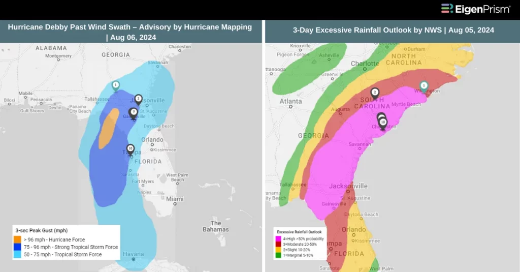 Tropical Storm Debby is currently moving across northern Florida and southeastern Georgia after making landfall on Florida’s Big Bend coast as a Category 1 hurricane. Although the storm has slightly weakened, it continues to bring dangerous storm surges and torrential rain to parts of the Gulf Coast. Tragically, at least five people have lost their lives due to the storm.
This week, multiple storm watches and warnings have been issued for Debby’s projected path through Florida, Georgia, and South Carolina. As Debby travels across the Southeast, it is expected to deliver heavy rainfall, gusty winds, and isolated tornadoes. The Storm Prediction Center has extended a tornado watch for the greater Charleston area in South Carolina. Flooding remains a significant concern as the slow-moving storm may dump torrential rainfall over several areas.
In Charleston, South Carolina, some roads are already flooding, according to the city’s police department, as heavy rain precedes Debby’s extended deluge. The NOAA has issued a high-risk flood outlook for the next few days. Late Monday night, a rain-wrapped tornado caused damage in Edisto Beach, South Carolina, downing trees, power lines, and damaging structures.
Portions of southeast Georgia, the coastal plains of South Carolina, and southeast North Carolina could see 10 to 20 inches of rainfall as Debby continues its path, with maximum amounts reaching up to 30 inches in some areas.
In Florida, approximately 150,000 homes and businesses were without power on Monday night, according to PowerOutage.com. Additionally, 36,000 residents in Georgia and South Carolina were experiencing outages.
Hurricane Debby Downgraded but Continues to Wreak Havoc Across the Southeastern US: Actionable Insights on EigenPrism
Post-Event
Subscribers of KatRisk can use these real-time footprints on EigenPrism® to quickly assess the impact:
Debby 2024 Inland Flood inundation footprint as of August 05
Debby Wind Speed Footprint from KatRisk as of August 05
Subscribers of ICEYE can use this real-time footprint on EigenPrism® to quickly assess the impact of flooding:
Tropical Cyclone Debby 2024 – Flood Inundation footprint from ICEYE as of August 05
All EigenPrism® users can assess the post-event of the tropical cyclone using the following report template.
Hurricane Debby 2024 Post-Event Impact Report
The report template auto-updates with the latest available footprints, which include:
- Hurricane Debby 2024 Past Max Winds by Adiabat
- Hurricane Debby Past Wind Swath – Advisory by Hurricane Mapping
Forecast
Subscribers of Reask can use this real-time footprint on EigenPrism® to quickly assess the impact:
Tropical Cyclone wind speed footprint from Reask LiveCyc as on August 05
All EigenPrism® users can assess the forecast of the tropical cyclone using the following report template.
Tropical Cyclone Forecast Impact Report (2024)
The report template auto-updates with the latest available footprints, which include:
- Tropical-Storm-Force (greater than 34 kt) Wind Arrival Times by NOAA
- Tropical Cyclone Forecast: Wind Swaths by Hurricane Mapping
- Tropical Cyclone Forecast: Maximum Winds by Adiabat
- 5-day Tropical-Storm-Force (greater than 34 kt) Wind Probabilities by Hurricane Mapping
- 5-day Hurricane-Force (greater than 64 kt) Wind Probabilities by Wind Hurricane Mapping
- 3-Day Excessive Rainfall Outlook by NWS
- 5-day Flood Potential by Adiabat
- 3-day Flood Potential by Adiabat
- Tropical Cyclone Forecast: Storm Surge Flooding Potential by NOAA
Aug 05 | Tropical Storm Debby Intensifies to Category 1 Hurricane, Threatens Florida with Heavy Rain and Flooding
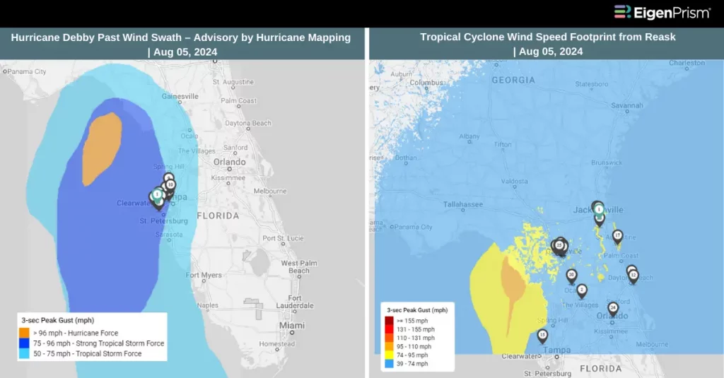 Hurricane Debby, the fourth named storm of the Atlantic hurricane season, and the second named hurricane has intensified into a Category 1 storm. According to a special update from the National Hurricane Center, Debby’s has made landfall in the Florida Big Bend area.
Debby is currently sustaining maximum winds of 80 mph, with stronger gusts. The hurricane is located about 40 miles west-northwest of Cedar Key and 80 miles south-southeast of Tallahassee, Florida, moving north-northeast at 12 mph.
The primary concern with this storm is flooding caused by heavy rainfall. While the highest rain totals will depend on the storm’s path, much of Florida is expected to experience significant rainfall.
Tropical storm conditions are already impacting Florida, with some areas receiving more than 10 inches of rain and over 100,000 residents losing power. The National Hurricane Center has warned that the storm could also produce tornadoes in Florida today.
A vast area of the coastal southeastern United States is under extreme, potentially life-threatening weather warnings. The National Hurricane Center’s 5 a.m. ET update extended the tropical storm warning southward to St. Augustine, Florida, from South Santee, South Carolina. Additionally, a hurricane warning is in effect along Florida’s Big Bend, from Yankeetown to Indian Pass.
Florida Under Threat as Hurricane Debby Nears Landfall: Actionable Insights on EigenPrism
Post-Event
All EigenPrism® users can assess the post-event of the tropical cyclone using the following report template.
Hurricane Debby 2024 Post-Event Impact Report
The report template auto-updates with the latest available footprints, which include:
- Hurricane Debby 2024 Past Max Winds by Adiabat
- Hurricane Debby Past Wind Swath – Advisory by Hurricane Mapping
Forecast
Subscribers of Reask can use this real-time footprint on EigenPrism® to quickly assess the impact:
Tropical Cyclone wind speed footprint from Reask LiveCyc as on August 05
All EigenPrism® users can assess the forecast of the tropical cyclone using the following report template.
Tropical Cyclone Forecast Impact Report (2024)
The report template auto-updates with the latest available footprints, which include:
- Tropical-Storm-Force (greater than 34 kt) Wind Arrival Times by NOAA
- Tropical Cyclone Forecast: Wind Swaths by Hurricane Mapping
- Tropical Cyclone Forecast: Maximum Winds by Adiabat
- 5-day Tropical-Storm-Force (greater than 34 kt) Wind Probabilities by Hurricane Mapping
- 5-day Hurricane-Force (greater than 64 kt) Wind Probabilities by Wind Hurricane Mapping
- 3-Day Excessive Rainfall Outlook by NWS
- 5-day Flood Potential by Adiabat
- 3-day Flood Potential by Adiabat
- Tropical Cyclone Forecast: Storm Surge Flooding Potential by NOAA
Aug 02 | Tropical Depression Near Florida to Intensify and become Tropical Storm Debby
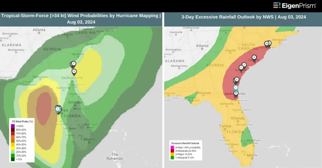 A tropical depression heading toward the Florida coast is forecasted to strengthen into Tropical Storm Debby by Saturday, bringing heavy rainfall and dangerous storm surges to the state starting this weekend.
As of late Friday, the storm’s maximum sustained winds were 30 mph, just below the 39 mph threshold required for tropical storm status. However, the National Hurricane Center predicts it will continue strengthening as it enters the eastern Gulf of Mexico on Saturday, becoming Tropical Storm Debby.
The Weather Prediction Center has issued a level 2 of 4 risk of flooding rainfall for much of South Florida on Saturday. Rainfall rates of 2.5 to 3 inches per hour are expected in the heaviest storms within the system’s outer rain bands.
The National Weather Service has issued a tropical storm warning for Florida’s west coast, from its southern tip to Boca Grande. This area, including Tampa Bay, is also under a storm surge watch, indicating the potential for life-threatening flooding as coastal waters surge inland.
As the storm approaches, rainfall will intensify and spread from south to north across much of Florida throughout the weekend. Rainfall totals of 4-8 inches, with isolated amounts up to 12 inches, are expected in some areas. The heavy rain will continue to affect the southeastern U.S. coast, potentially bringing rain and wind to Georgia, South Carolina, and North Carolina by Monday morning.
By Monday, the storm is predicted to move into the Atlantic Ocean or near the Southeast coast, but this forecast may change. Heavy rain is likely to impact coastal areas of Georgia, South Carolina, and North Carolina through Wednesday.
Tropical Depression Expected to Intensify into Tropical Storm Debby: Actionable Insights on EigenPrism
All EigenPrism® users can assess the forecast of the tropical cyclone using the following report template.
Tropical Cyclone Forecast Impact Report (2024)
The report template auto-updates with the latest available footprints, which include:
- Tropical-Storm-Force (greater than 34 kt) Wind Arrival Times by NOAA
- Tropical Cyclone Forecast: Wind Swaths by Hurricane Mapping
- Tropical Cyclone Forecast: Maximum Winds by Adiabat
- 5-day Tropical-Storm-Force (greater than 34 kt) Wind Probabilities by Hurricane Mapping
- 5-day Hurricane-Force (greater than 64 kt) Wind Probabilities by Wind Hurricane Mapping
- 3-Day Excessive Rainfall Outlook by NWS
- 5-day Flood Potential by Adiabat
- 3-day Flood Potential by Adiabat
- Tropical Cyclone Forecast: Storm Surge Flooding Potential by NOAA
Escape the News Cycle | Get Alerts Automatically For Events Impacting Your Assets
With EigenPrism Alerts, you can set Alerts and free yourself from constant event monitoring. Set up personalized alerts based on predefined impact thresholds and choose how you receive them – via email, SMS, or directly within EigenPrism. This way, you stay informed on your own terms, focusing only on the events that truly matter to your assets.
Set your alerts now.
Don’t have access to EigenPrism®?
Sign up for a trial account and access full impact reports of all events. Contact us, and we’ll set up a trial account for you.