Salt Fire and South Fork Fire Continue to Ravage, Burning 23,000+ Acres
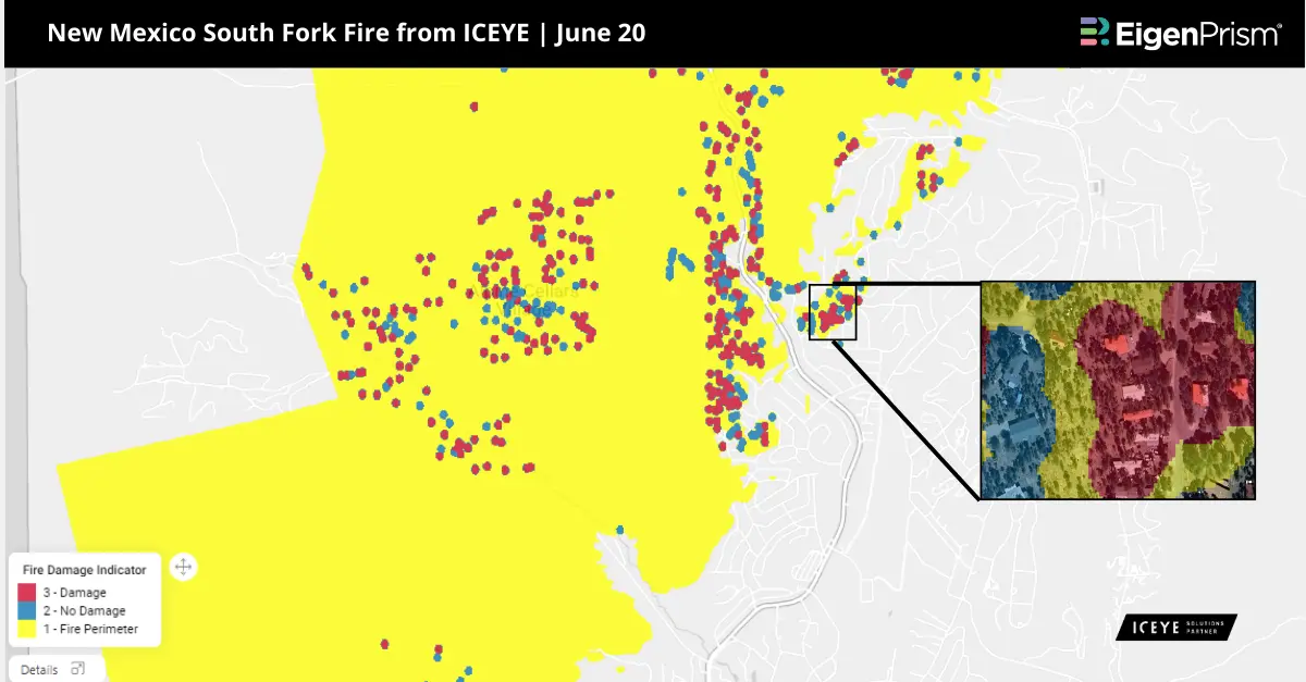
The South Fork and Salt Fires continue to ravage the Ruidoso, New Mexico area, with over 23,000 acres affected. As of June 21, 2024, the South Fork Fire has burned over 16335 acres , while the Salt Fire has burned over 7,071 acres. Approximately 1,400 structures have been destroyed, with an estimated 50% being homes. Whole communities have been reduced to ashes, leaving only foundations and charred trees behind. Both fires remain at zero containment, with intense heat and long-range spotting observed across the affected areas. Firefighters are battling the blazes amid challenging weather conditions while trying to contain the spread of the fires.
Salt Fire and South Fork Fire In New Mexico: Actionable Insights on EigenPrism
Subscribers of ICEYE can use the report template on EigenPrism®, to quickly assess the impact of wildfire:
New Mexico Wildfire June 2024 Building Damage Assessment from ICEYE
The report template auto-updates with the latest available footprints, which include:
- South Fork Fire – NM
- Salt Fire – NM
All EigenPrism® users can assess the impact using the following report template:
New Mexico Active Wildfire June 2024 Report
The report template auto-updates with the latest available footprints, which include:
- NM Encerrita Wildfire Proximity Map from NIFC
- NM Salt Wildfire Proximity Map from NIFC
- NM South Fork Wildfire Proximity Map from NIFC
_____________________________________
Salt Fire and South Fork Fire burn 20,000+ Acres in New Mexico – June 20,2024
Two devastating wildfires are engulfing the Mescalero Apache tribal reservation and threatening the village of Ruidoso in New Mexico.
The South Fork fire, which started on June 17, 2024, has rapidly grown to 15,276 acres and is currently one percent contained. It has led to the evacuation of roughly 5,000 residents from the Ruidoso village. Over 500 structures have been damaged, 2 reportedly dead and the entire village, with a population of 7,000, has been evacuated due to the extreme fire activity.
The Salt Fire began on June 19, 2024 in Otero County, New Mexico, southwest of the village of Ruidoso. As of June 20, the Salt Fire had burned over 7,000 acres and was 0% contained. The situation remains critical, with the fire exhibiting intense heat and long-range spotting.
The area around Ruidoso could see rainfall totals of 1 to 3 inches and rainfall rates of over an inch per hour, according to the National Weather Service, which could help with fire relief, though heavy rains can also cause flash flooding and debris flows over recent burn scars. The National Weather Service issued a flash flood warning for Lincoln County on Wednesday afternoon.
Salt Fire and South Fork Fire In New Mexico: Actionable Insights on EigenPrism
Subscribers of ICEYE can use the report template on EigenPrism®, to quickly assess the impact of wildfire:
New Mexico Wildfire June 2024 Building Damage Assessment from ICEYE
All EigenPrism® users can assess the impact using the following report template:
New Mexico Active Wildfire June 2024 Report
The report template auto-updates with the latest available footprints, which include:
- NM Encerrita Wildfire Proximity Map from NIFC
- NM Salt Wildfire Proximity Map from NIFC
- NM South Fork Wildfire Proximity Map from NIFC
Escape the News Cycle | Get Alerts Automatically For Events Impacting Your Assets
With EigenPrism Alerts, you can set Alerts and free yourself from constant event monitoring. Set up personalized alerts based on predefined impact thresholds and choose how you receive them – via email, SMS, or directly within EigenPrism. This way, you stay informed on your own terms, focusing only on the events that truly matter to your assets.
Set your alerts now.
Don’t have access to EigenPrism®?
Sign up for a trial account and access full impact reports of all events. Contact us, and we’ll set up a trial account for you.