After Ravaging Japan, Typhoon Khanun Heads to South Korea with Destructive Force: Get Actionable Insights on EigenPrism
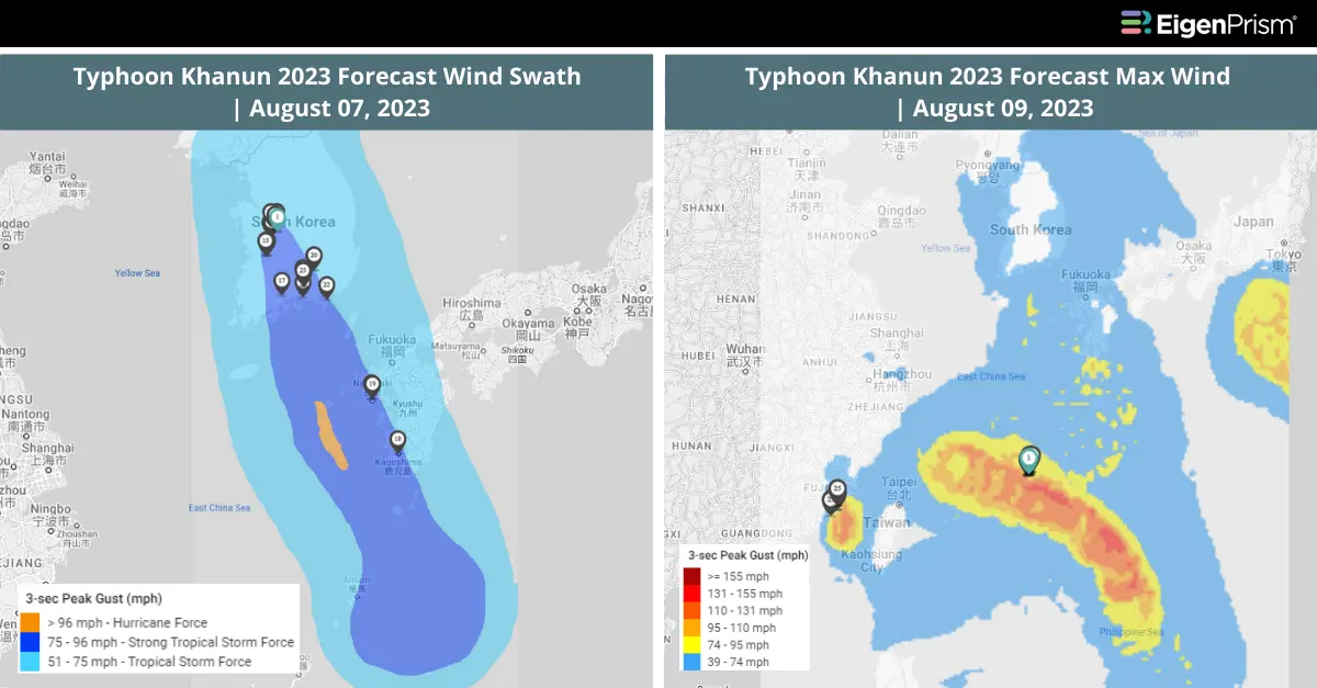
Typhoon Khanun has already inflicted significant damage in southern Japan and, as of Tuesday afternoon it was advancing toward South Korea. The typhoon is carrying torrential rain and winds reaching speeds of up to 78 mph.
On Monday afternoon, Typhoon Khanun sustained winds of 67 mph, accompanied by stronger gusts. Tragically, the storm resulted in one fatality and 70 injuries on Okinawa, a southern Japanese island.
Anticipated to make landfall in the southern regions of South Korea on Wednesday afternoon, Typhoon Khanun has prompted the government to elevate its typhoon alert to the highest level. In preparation for the storm’s approach, certain roads, mountain trails, and beaches have been closed. In an effort to ensure their safety in light of the approaching typhoon, South Korea evacuated the majority of teenage scouts from their campsite on Tuesday.
Typhoon Khanun, South Korea: Actionable Insights on EigenPrism
To make timely decisions about this event, EigenPrism® users can assess the forecast of the event using the following quick links:
- Typhoon Khanun Forecast Wind Swath – Advisory 47 as of 2023-08-07
- Typhoon Khanun 2023 5-day Forecast Max Winds as of 2023-08-09
Don’t have access to EigenPrism?
Sign up for a trial account and access complete impact reports of all events. Contact us and we’ll set up a trial account for you.
August 3, 2023 | Typhoon Khanun Impacts Okinawa, Japan, Leaving Over 600,000 Without Power: Assess the Impact
On Thursday, Typhoon Khanun moved close to northeast Taiwan, prompting warnings of floods and high winds. On Wednesday, the typhoon came within a few miles of the southwest Okinawa islands of Japan, with winds of 137 mph (equivalent to a Category 4 Atlantic hurricane). The region experienced heavy rainfall of 6 to 8 inches, leading to evacuation orders for over 600,000 residents and power outages for more than 200,000 households.
The center of Typhoon Khanun is expected to linger in the East China Sea for the next 48 hours. It may turn toward Japan’s northern Ryukyu Islands over the weekend, avoiding a direct impact on China’s eastern coast, which has already been affected by the remnants of Typhoon Doksuri.
Typhoon Khanun is gradually weakening due to its slow movement, but in the next few days, its outer bands may still bring heavy rain and high gusts to China’s eastern Zhejiang province and the coastal regions close to Shanghai.
Actionable Insights on EigenPrism
To make timely decisions about this event, EigenPrism® users can assess the impact using the following quick links:
- Typhoon Khanun Past Wind Swath – Advisory 29 as of 2023-08-03
- Typhoon Khanun 2023 5-day Past Max Winds as of 2023-08-03
Subscribers of ICEYE can use these real-time footprints on EigenPrism®, to quickly assess the impact of flooding:
- TyphoonKhanun – Okinawa (Japan) 2023 – Flood Extent Footprint from ICEYE as of 2023-08-02
- TyphoonKhanun – Okinawa (Japan) 2023 – Flood Inundation Footprint from ICEYE as of 2023-08-02
To make timely decisions about this event, EigenPrism® users can assess the forecast of the event using the following quick links:
- Typhoon Khanun Forecast Wind Swath – Advisory 29 as of 2023-08-03
- Typhoon Khanun 2023 5-day Forecast Max Winds as of 2023-08-03
Don’t have access to EigenPrism?
Sign up for a trial account and access complete impact reports of all events. Contact us and we’ll set up a trial account for you.