Typhoon Doksuri Triggers Intense Rainfall in Beijing: Assess the Impact
On Sunday, the Chinese capital of Beijing experienced its most intense rainfall of the year as the remnants of Typhoon Doksuri passed through the city. The average rainfall in Beijing reached 5.5 inches, with the Fangshan area recording a maximum of 19.7 inches. This led to the evacuation of more than 31,000 residents from high-risk areas.
The storm, known as Typhoon Egay in the Philippines, affected five regions and resulted in numerous rain-induced landslides prior to making landfall in China. Typhoon Egay also caused considerable flooding in the Philippines.
Typhoon Doksuri is one of the strongest storms to hit China in years. Millions of people in the northern areas of the country, including Beijing and Tianjin, were placed on the highest level of red alert for severe rain. The alert also covered parts of Hebei, Shanxi, Shandong, and Henan provinces. The southern and western regions were expected to face even heavier rains on Monday morning.
Actionable Insights on EigenPrism
To make timely decisions about this event, EigenPrism® users can assess the impact using the following quick links:
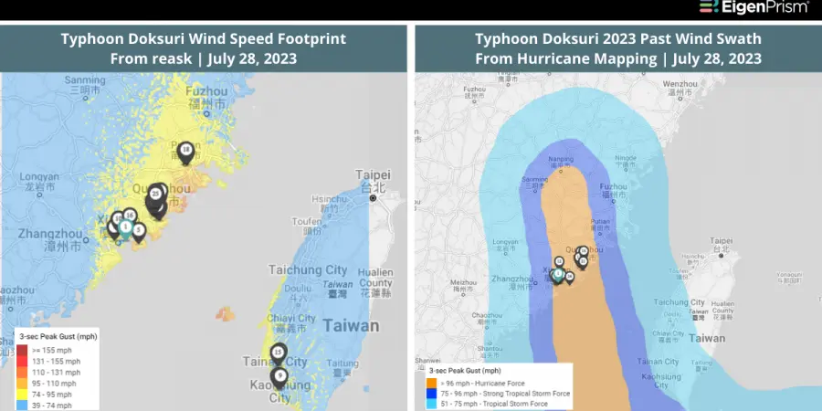
- Typhoon Doksuri Past Wind Swath – Advisory 28 as of 2023-07-28
- Typhoon Doksuri 2023 5-day Past Max Winds as of 2023-07-29
- Landslide Potential as of 2023-07-30
Subscribers of reask can use these real-time footprints on EigenPrism®, to quickly assess the impact:
- Typhoon Doksuri HindCyc Footprint as of 2023-07-28
Don’t have access to EigenPrism?
Sign up for a trial account and access complete impact reports of all events. Contact us and we’ll set up a trial account for you.
July 24, 2023 | Typhoon Doksuri Threatens Taiwan, Hong Kong, and Mainland China: Actionable Insights on EigenPrism
Typhoon Doksuri has been rapidly intensifying and is currently advancing toward the Philippines. It has the potential to evolve into a supertyphoon by Wednesday, posing a threat to Taiwan, Hong Kong, or mainland China later this week.
Currently, the typhoon has a maximum wind speed of 140 miles per hour. It is on track to approach Luzon, the largest and most populous island in the Philippines, where it is anticipated to make landfall on the northeastern edge on Tuesday, bringing heavy rainfall of up to 10 inches.
As the typhoon gains strength and moves towards the northern part of the South China Sea, rainfall could escalate to about 18 inches by Wednesday, increasing concerns for Taiwan, Hong Kong, and parts of southern China.
The typhoon could pass over the island of Taiwan; it could swing south, missing Taiwan and hitting the southern coast of China’s Guangdong instead, including Hong Kong; or it could go north, largely sparing both. It is expected to weaken late Wednesday, according to Pagasa’s forecast.
Actionable Insights on EigenPrism
To make timely decisions about this event, EigenPrism® users can assess the forecast using the following quick links:
- Hurricane-Force (>64 kt) Wind Probabilities for the 120 hours as of 2023-07-23
- Typhoon Doksuri Forecast Wind Swath – Advisory 09 as of 2023-07-23
- Typhoon Doksuri 2023 5-day Forecast Max Winds as of 2023-07-24
Don’t have access to EigenPrism?
Sign up for a trial account and access complete impact reports of all events. Contact us and we’ll set up a trial account for you.