Prolonged Winter Storm Caused Life-Threatening Temperatures & and Freezing Winds
The severe winter storm struck most of the US over the past weekend, causing 250,000 power outages on Christmas morning, with Maine and New York accounting for roughly half of those affected.
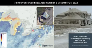
The most impacted region was Buffalo, New York, where 43 inches of snow had fallen as of Sunday morning, according to NWS. Just south of Buffalo, Hamburg and the entire western New York region also suffered the wrath of this massive winter storm. Hoak’s restaurant near lake Erie in Hamburg, was encased in ice.
New York Gov. Kathy Hochul said the storm is the “most devastating storm in Buffalo’s long storied history.” Freezing winds and low temperatures were also recorded. Western New York is currently drowning in thick “lake effect” snow, which accumulates when cold air flows over the warm waters of the Great Lakes.
This was the coldest Christmas in Florida since 1983, especially in Miami, Tampa, Orlando, and West Palm Beach. Later in the week, temperatures are expected to increase due to a warming trend and above-normal temperatures.
Assessing the Impact
EigenPrism® users can check the following quick links to assess the winter storm.
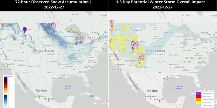
- 72-hour observed snow accumulation as of 2022-12-27 – v3 | v4
- 1-3 Day Potential Winter Storm Overall Impact as of 2022-12-27 – v3 | v4
- 72-Hr Forecast Snow Accumulation (90th Percentile) as of 2022-12-27 – v3 | v4
- 72-Hr Forecast Freezing Rain Accumulation (90th Percentile) as of 2022-12-27 – v3 | v4
December 23, 2022 | ‘Once-in-a-generation’ Winter Storm Causes Record-Breaking Temperature Drops and Freezes Travel
A major winter storm sweeping across the central and eastern US is bringing record-breaking temperature drops and harsh snowy conditions. The NWS calls it a “Once-in-a-generation” event. The storm has led to power outages, flight cancellations, and highway closures, and prompted emergency responses for multiple states ahead of Christmas weekend. Over 200 million people in the US are currently under wind chill alerts.
Wind chills below minus 50 degrees Fahrenheit were recorded in the past two days for parts of Montana, South Dakota, and Wyoming. Denver International Airport recorded a 37-degree temperature drop, the largest ever for that location. In only 10 minutes, the temperature in Cheyenne, Wyoming, dropped by 30 degrees. On Friday, more heavy snow and blizzard conditions are expected, particularly in the Midwest is expected.
As the storm treks east, it will intensify into a “bomb cyclone” by dropping 24 millibars of pressure within 24 hours. The storm’s pressure is forecast to match that of a Category 2 hurricane as it moves into the Great Lakes Friday. According to the NWS, the ongoing storm will continue to produce heavy snow, strong winds, and life-threatening wind chills through Saturday.
Assessing the Impact
EigenPrism® users can check the following quick links to assess the winter storm.
- 72-hour observed snow accumulation as of 2022-12-23 – v3 | v4
- 1-3 Day Potential Winter Storm Overall Impact as of 2022-12-23 – v3 | v4
- 72-Hr Forecast Snow Accumulation (90th Percentile) as of 2022-12-23 – v3 | v4
- 72-Hr Forecast Freezing Rain Accumulation (90th Percentile) as of 2022-12-23 – v3 | v4
December 20th, 2022 | Major Winter Storm – Potential Bomb Cyclone – to Impact the Northeast US This Week
A major winter storm may develop into a bomb cyclone over the Midwest before Christmas Eve. It will bring cold winds to the East Coast and blizzard conditions to regions of the Great Lakes.
In addition, this storm will bring severely cold air as far south as Texas, the Gulf Coast, and Florida to a large portion of the country. Significant amounts of snow will fall across much of the Midwest and will even go as far south as the Lower Mississippi Valley.
Winter storm alerts, including watches and advisories, have already been issued for Chicago, Des Moines, Milwaukee, Minneapolis-St. Paul, and Omaha.
Assessing the Impact
EigenPrism® users can check the following quick links to assess the impact of the winter storm.
- 1-3 Day Potential Winter Storm Overall Impact as of 2022-12-20 – v3 | v4
- 72-Hr Forecast Snow Accumulation (90th Percentile) as of 2022-12-20 – v3 | v4
- 72-Hr Forecast Freezing Rain Accumulation (90th Percentile) as of 2022-12-20 – v3 | v4
Don’t have access to EigenPrism®?
Sign up for a trial account and access full impact reports of all events. Contact us and we’ll set up a trial account for you.