Northeast US Braces for Heavy Snowfall as South Struggles with Tornado Aftermath
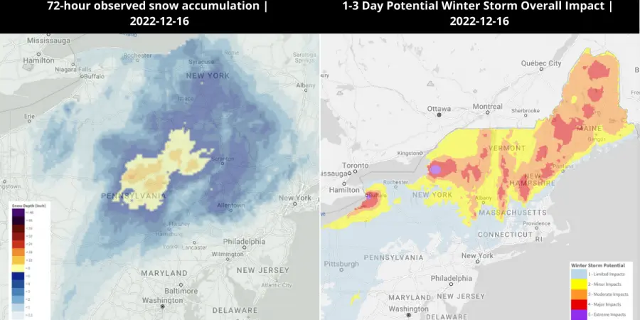
The powerful storm system that has already caused heavy destruction in the US, will cause a new wave of severe weather as of Thursday. Parts of Pennsylvania, New Jersey, and New York have already received several inches of snow and are expected to receive more than a foot of new snow in the coming days. Higher elevation areas might have up to two feet of snowfall. Furthermore, the Mid-Atlantic and New England are expected to be covered in heavy ice and snow. According to CNN, the upper Midwest has seen more than a foot of snow since Monday including – Colorado, Wyoming, Montana, Nebraska, the Dakotas, Minnesota, and Wisconsin. The storm system that is currently battering eastern areas with severe weather also devastated the Gulf Coast. Since Tuesday, at least 50 tornadoes and 100,000 power outages have been reported in Mississippi, Louisiana, Florida, Texas, Alabama, Georgia, and Oklahoma.
Assessing the Impact
EigenPrism® users can check the following quick links to assess the impact of the storm.
- 1-3 Day Potential Winter Storm Overall Impact as of 2022-12-16 – v3 | v4
- 72-Hr Forecast Snow Accumulation (90th Percentile) as of 2022-12-16 – v3 | v4
- 72-hour observed snow accumulation as of 2022-12-16 – v3 | v4
- 72-Hr Forecast Freezing Rain Accumulation (90th Percentile) as of 2022-12-16 – v3 | v4
For subscribers of Canopy Weather real-time tornado footprints within EigenPrism® are now available for analysis.
December 15th, 2022 | Severe Weather Across US is Moving Eastward: Tornadoes, Damaging Wind Gusts and Large Hail Threats Today Severe Weather moving across the Southern US has already produced a deadly tornado outbreak. NWS has reported 49 tornadoes across Louisiana, Mississippi, Texas, Alabama, and Florida since Tuesday. Power outages were reported for more than 45,000 customers in Louisiana and more than 9,000 in Mississippi. The hardest hit areas were from Gretna to Arabi in Louisiana. More than 5000 structures were likely damaged in the city of Gretna. The Iberia Medical Center (Louisiana) also sustained a significant amount of damage. 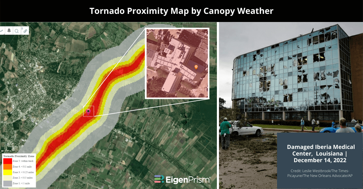 This massive storm system is moving into the Southeast on Thursday dumping heavy snow along the way. Severe Weather is expected in South Carolina, parts of South Georgia and Florida. Damaging wind gusts, large hail and multiple tornadoes may also hit Charleston (South Carolina), Savannah (Georgia) in addition to Jacksonville, Orlando, Tallahassee and Tampa (Florida).
Assessing the Impact
EigenPrism® users can check the following quick links to assess the impact of the storm.
- Significant Tornado Outlook as of 2022-12-15 – v3 | v4
- 24-Hr Rotational Track ending as of 2022-12-14 – v3 | v4
- 1-3 Day Potential Winter Storm Overall Impact as of 2022-12-15 – v3 | v4
- 72-Hr Forecast Snow Accumulation (90th Percentile) as of 2022-12-15 – v3 | v4
- 72-hour observed snow accumulation as of 2022-12-14 – v3 | v4
- 72-Hr Forecast Freezing Rain Accumulation (90th Percentile) as of 2022-12-15 – v3 | v4
- Tornado LA Iberia County on 2022/12/14 – v3 | v4
- Tornado LA Jefferson County on 2022/12/14 – v3 | v4
For subscribers of Canopy Weather, real-time tornado footprints within EigenPrism® are now available for analysis.
December 13th, 2022 | Major Storm Hits the US: Blizzard Conditions, flooding and Tornadoes Expected A significant winter storm that hit the western US over the weekend dumped heavy snow in mountainous regions. The storm is now expected to move across the country, posing a threat of blizzard conditions, strong tornadoes, and flooding throughout the week. The Upper Midwest, Northern, and Central Plains will be the worst impacted. The Northern High Plains expect 6 to 12 inches of snowfall by Tuesday morning. Western South Dakota and Northwest Nebraska are expected to receive the most snow, with potential accumulations of up to 24 inches. While the storm brings whiteout conditions to the North, it may also deliver late-season tornadoes and powerful thunderstorms to the South. Tornadoes are expected to develop over western Kansas, Texas, and parts of Oklahoma on Monday. Heavy rainfall may also lead to flooding in the Lower Mississippi River Valley. Assessing the Impact EigenPrism® users can check the following quick links to assess the storm’s impact:
- 1-3 Day Potential Winter Storm Overall Impact as of 2022-12-13 – v3 | v4
- 72-Hr Forecast Snow Accumulation (90th Percentile) as of 2022-12-13 – v3 | v4
- 72-hour observed snow accumulation as of 2022-12-13 – v3 | v4
- 72-Hr Forecast Freezing Rain Accumulation (90th Percentile) as of 2022-12-13 – v3 | v4
December 11th, 2022 | Major Storm Hits the U.S. – Heavy Snowfall, Rain and Tornadoes Expected A significant winter storm is expected to move across the United States this weekend. It will result in tornadoes in the South, blizzard conditions in the Northern Plains, and heavy snowfall to the West. The main cause of the storm is said to be an atmospheric river event that is bringing ample amounts of moisture. In Sierra Nevada, heavy snowfall rates of 3 inches per hour are predicted, and some regions can expect accumulations of more than 5 feet by Sunday. Rainfall and flooding concerns will last through Sunday along the entire West Coast, particularly in California. Winter weather warnings are in effect for more than a dozen western states this weekend as the powerful storm system passes through the area.
Assessing the Impact
EigenPrism® users can check the following footprints to assess the impact of the storm.
- 1-3 Day Potential Winter Storm Overall Impact as of 2022-12-11 – v3 | v4
- 72-Hr Forecast Snow Accumulation (90th Percentile) as of 2022-12-11 – v3 | v4
- 72-hour observed snow accumulation as of 2022-12-11 – v3 | v4
- 72-Hr Forecast Freezing Rain Accumulation (90th Percentile) as of 2022-12-11 – v3 | v4
Don’t have access to EigenPrism®?
Sign up for a trial account and access full impact reports of all events. Contact us and we’ll set up a trial account for you.