Ian Devastates Florida Causing Flooding and Power Outages, Heads to South Carolina
Hurricane Ian slammed the southwest coast of Florida on Wednesday as a Category 4 hurricane. Presently it has been downgraded to a Category 1 storm and is expected to make another landfall in South Carolina on Friday. It is located 70 miles south of Orlando. It has maximum sustained winds of 90 mph which are diminishing further.
It tore apart houses and other structures in Florida, leaving some inhabitants trapped as storm surge swamped neighborhoods. More than 2 million residents were reported without electricity.
In addition, Ian produced tornadoes that significantly damaged Miami and Southern Florida. Many areas including Fort Myres, Charlotte County, Osceola County, and Sarasota County reported severe destruction.
After making landfall in Carolina, Ian is expected to dissipate or merge with another area of low pressure by this weekend.
Assessing the Impact
The latest NOAA* remote sensing imagery for Hurricane Ian is now available in EigenPrism®.
 To access the imagery, follow these steps:
- Login to EigenPrism® and select the appropriate exposure for your analysis.
- Hover over the Event Catalog icon, then click on the WMS Layer Overlay icon when it appears in the drop-down:
- Type “Hurricane Ian” in the search box, select the option that appears and click Go.
 The imagery layers** will appear in the drop-down; select an individual layer or multi-select, and the images will be overlaid on your exposures.
- You can now zoom in to any location of interest and assess the imagery.
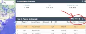
- Turn on the “in map view” option to investigate assets within the zoomed area on the map:
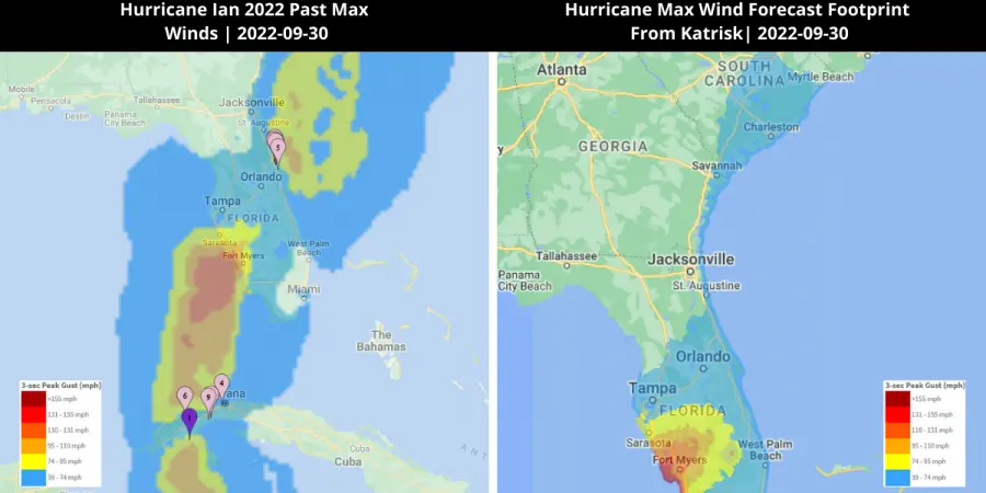
 EigenPrism® users can access the following quick links to track Hurricane Ian. You can immediately overlay the following footprints on your exposure:
- Hurricane Ian 2022 Past Max Winds as of 2022-09-30
- Hurricane Ian Past Wind Swath Advisory 31 as of 2022-09-30
- Hurricane-Force (>64 kt) Wind Probabilities for the 120 hours from 2022-09-30 to 2022-10-05
- Tropical-Storm-Force (>34 kt) Wind Probabilities for the 120 hours from 2022-09-30 to 2022-10-05
- Tropical Storm Ian 2022 5-day Forecast Max Winds as of 2022-09-29
- Flood Forecast: Precipitation-based Flood Potential for North America as of 2022-09-29
- Hurricane Ian Storm Surge Potential: Advisory #30 as of 2022-09-30
- 3-Day Excessive Rainfall Outlook from 2022-09-28 to 2022-10-01
For subscribers of Katrisk, ICEYE and Reask real-time flood and hurricane footprints within EigenPrism® are now available for analysis. Please note that reask has made their Hurricane Ian Wind Speed Footprint available to all EigenPrism® users at no cost:
- Hurricane Ian HindCyc Footprint from Reask as of 2022-09-29
- Hurricane Ian 2022 Max Wind Footprint from Katrisk as of 2022-09-29
- Hurricane Ian 2022 Inland Flood Inundation Forecast Footprint from Katrisk as of 2022-09-29
- Hurricane Ian 2022 Forecast Storm Surge footprint from Katrisk as of 2022-09-29
- Hurricane Ian 2022 Flood Inundation Footprint from ICEYE as of 2022-09-29
*NOAA Disclaimer:
This imagery was acquired by the NOAA Remote Sensing Division to support NOAA homeland security and emergency response requirements. The data provided on this site is for informational and planning purposes only. Absolutely no accuracy or completeness guarantee is implied or intended.
September 29, 2022 | Ian Devastates Florida, Knocking out Power and Causing Flooding in Several Places
Hurricane Ian, one of the strongest storms to hit Florida, made landfall on Wednesday afternoon near Cayo Costa in Southwestern Florida. Ian slammed the area with destructive 150 mph gusts as it moved farther inland and drove rushing ocean water onshore.
As of early Thursday, the massive storm flooded roads, and homes left more than 2 million people without power, toppled trees, and sent cars floating down the street. The center of the storm is around 55 miles to the south-Southeast of Orlando
Several areas, including Punta Gorda, Port Charlotte, Fort Myers, and Naples, received high storm surges of 12 to 16 feet. Up to 20 inches of rain was expected for several locations, including Lehigh Acres, which received 14.42 inches of rain, and Warm Mineral Springs, which received 11.05 inches.
It has already weakened to a Category 1 hurricane and is meandering over Central Florida as it moves toward the east coast, dumping a lot of rain on low-lying areas. Warnings have been issued for a portion of Florida’s east and west coastlines from Sebastian Inlet to Flagler-Volusia County. It is anticipated to leave Florida and go towards the Atlantic Ocean on Thursday.
Assessing the Impact
EigenPrism® users can access the following quick links to track Hurricane Ian. You can immediately overlay the following footprints on your exposure:
- Hurricane Ian 2022 Past Max Winds as of 2022-09-29
- Hurricane Ian Past Wind Swath Advisory 27 as of 2022-09-29
- Hurricane-Force (>64 kt) Wind Probabilities for the 120 hours from 2022-09-29 to 2022-10-04
- Tropical-Storm-Force (>34 kt) Wind Probabilities for the 120 hours from 2022-09-29 to 2022-10-04
- Tropical Storm Ian 2022 5-day Forecast Max Winds as of 2022-09-29
- Flood Forecast: Precipitation-based Flood Potential for North America as of 2022-09-29
- Hurricane Ian Storm Surge Potential: Advisory #26 as of 2022-09-29
- 3-Day Excessive Rainfall Outlook from 2022-09-28 to 2022-10-01
For subscribers of Katrisk and Reask real-time flood and hurricane footprints within EigenPrism® are now available for analysis. Please note that reask has made their Hurricane Ian Wind Speed Footprint available to all EigenPrism® users at no cost:
- Hurricane Ian HindCyc Footprint from Reask as of 2022-09-29
- Hurricane Ian 2022 Max Wind Footprint from Katrisk as of 2022-09-28
- Hurricane Ian 2022 Inland Flood Inundation Forecast Footprint from Katrisk as of 2022-09-28
- Hurricane Ian 2022 Forecast Storm Surge footprint from Katrisk as of 2022-09-28
September 28, 2022 | Ian Batters Florida with Catastrophic Winds, Surge, and Flooding
Hurricane Ian, currently a Category 4 storm, is likely to make Landfall in Florida today. As of now, it has maximum sustained winds of 140 mph. Parts of the Florida Peninsula and the Florida Keys are now being lashed by bands of heavy rain and strong winds.
On Sanibel Island, wind gusts have lately reached 55 mph, while a buoy close to Ian’s eye recorded a gust of up to 94 mph. A storm surge warning is in effect from the Flagler-Volusia County line to the Georgia state line, from the Suwanee River to the peninsula’s farthest southwest tip, including Tampa Bay.
It already made landfall in Western Cuba on Tuesday with winds of up to 127 mph. As Hurricane Ian tore across the western part of the island, Cuba’s electrical grid failed, leaving the country’s 11 million residents without electricity. Pinar del Rio region in Cuba is completely devastated due to the strong winds that came along with the hurricane.
Assessing the Impact
EigenPrism® users can access the following quick links to track Hurricane Ian. You can immediately overlay the following footprints on your exposure:
- Hurricane-Force (>64 kt) Wind Probabilities for the 120 hours from 2022-09-28 to 2022-10-03
- Tropical-Storm-Force (>34 kt) Wind Probabilities for the 120 hours from 2022-09-28 to 2022-10-03
- Hurricane Ian Forecast Wind Swath Advisory 21A as of 2022-09-28
- Tropical Storm Ian 2022 5-day Forecast Max Winds as of 2022-09-28
- Flood Forecast: Precipitation-based Flood Potential for North America as of 2022-09-28
- Hurricane Ian Storm Surge Potential: Advisory #21 as of 2022-09-28
- 3-Day Excessive Rainfall Outlook from 2022-09-28 to 2022-10-01
For subscribers of Reask and Katrisk real-time flood and hurricane footprints within EigenPrism® are now available for analysis. Please note that reask has made their Hurricane Ian Wind Speed Footprint available to all EigenPrism® users at no cost:
- Hurricane Ian HindCyc Footprint from Reask as of 2022-09-28
- Hurricane Ian 2022 Max Wind Footprint from Katrisk as of 2022-09-28
- Hurricane Ian 2022 Inland Flood inundation footprint from Katrisk as of 2022-09-27
- Hurricane Ian 2022 Forecast Storm Surge footprint from Katrisk as of 2022-09-27
Impact Summary Report:
EigenPrism users can make use of the report template ‘SAMPLE Ian 2022 Forecast Impact Summary‘. You can copy the report template and apply it to your own exposure.
Please note, as report templates are frequently updated, you can refresh the report by changing the Analysis Date-See instructions here.
September 25, 2022 | Hurricane Ian expected to strengthen to Category 3 by Monday night; Headed for a landfall in Florida this week
Hurricane Ian has become the fifth hurricane of the Atlantic season and is expected to rapidly intensify on Monday. Ian is currently forecast to make landfall on the west coast of Florida or the Florida Panhandle by midday Thursday, though there is uncertainty about the hurricane’s track and intensity.
State of emergency has been declared by Florida government as the “storm conditions are pointing to constitute a major disaster”.
Assessing the Impact
EigenPrism® users can access the following quick links to track Hurricane Ian. You can immediately overlay the following footprints on your exposure:
- Hurricane-Force (>64 kt) Wind Probabilities for the 120 hours from 2022-09-26 to 2022-10-1
- Tropical-Storm-Force (>34 kt) Wind Probabilities for the 120 hours from 2022-09-25 to 2022-10-1
- Hurricane Ian Forecast Wind Swath Advisory 14 as of 2022-09-26
- Tropical Storm Ian 2022 5-day Forecast Max Winds as of 2022-09-25
- Flood Forecast: Precipitation-based Flood Potential for North America as of 2022-09-26
- Hurricane Ian Storm Surge Potential: Advisory #014 as of 2022-09-26
- 3-Day Excessive Rainfall Outlook from 2022-09-26 to 2022-09-29
Impact Summary Report:
EigenPrism users can make use of the report template ‘SAMPLE Ian 2022 Forecast Impact Summary‘. This report will have all the aforementioned footprints already applied. You can copy the report template and apply it to your own exposure –See instructions here.
Please note, as report templates are frequently updated, you can refresh the report by changing the Analysis Date.
September 25, 2022 | Tropical Storm Ian Strengthens, Forecasted to Impact Florida as Hurricane
Tropical Storm Ian is strengthening to become a hurricane in the Caribbean Sea. Florida and the Southeast of the United States might face a serious hurricane threat from Ian. Earlier on Friday Night, before its intensification into a storm, the hurricane was known as Tropical Depression Nine.
As of Sunday, the storm had windspeed of 45mph. It is expected to make landfall in Florida on early Tuesday or Wednesday. It is also anticipated to move near Western Cuba, the Cayman Islands, and Jamaica early Monday.
A hurricane warning has been issued for 24 counties over the parts of Florida’s peninsula including North Florida, Big Bend, and Northeast Florida of the Cayman Islands. These areas are likely to experience, high gusts, deadly storm surges, flash floods, and heavy rain.
Assessing the Impact
EigenPrism® users can access the following quick links to track Tropical Storm Ian. You can immediately overlay the following footprints on your exposure:
- Hurricane-Force (>64 kt) Wind Probabilities for the 120 hours from 2022-09-25 to 2022-09-30
- Tropical-Storm-Force (>34 kt) Wind Probabilities for the 120 hours from 2022-09-25 to 2022-09-30
- Tropical-Storm-Ian Forecast Wind Swath-Advisory 08 as of 2022-09-25
- Tropical Storm Ian 2022 5-day Forecast Max Winds as of 2022-09-25
September 23, 2022 | Tropical Depression Nine Forecasted to Become Hurricane Hermine
Tropical Depression Nine, which is now located northwest of Trinidad and Tobago may soon develop into Hurricane Hermine. As of now, South Florida is in the forecasted cone for this tropical depression.
The Southern Caribbean will provide a conducive setting for the system to strengthen. As it moves over the Western Caribbean, where there is less shear and very warm sea surface temperatures, the storm may intensify into a hurricane.
Depending on the precise course and intensity, regions from Central America to Jamaica and Cuba might be impacted.
Assessing the Impact
EigenPrism® users can access the following quick links to track Tropical depression Nine. You can immediately overlay the following footprints on your exposure:
- Hurricane-Force (>64 kt) Wind Probabilities for the 120 hours from 2022-09-23 to 2022-09-28
- Tropical-Storm-Force (>34 kt) Wind Probabilities for the 120 hours from 2022-09-23 to 2022-09-28
- Tropical Storm Nine 2022 5-day Forecast Max Winds as of 2022-09-23
Don’t have access to EigenPrism®?
Sign up for a trial account and access full impact reports of all events. Contact us and we’ll set up a trial account for you.