Nor’easter Bomb Cyclone Slams the US Northeast with Heavy Snow and Strong Winds
January 29
According to The Weather Channel, winter storm Kenan is spreading heavy snow and strong winds in parts of East Coast. The nor’easter bomb cyclone is rapidly strengthening as it tracks off the East Coast threatening the region with dangerous combination of heavy snow and vicious winds along the I-95 corridor in the Northeast. Approximately 115,000 residents are facing power outages in parts of Massachusetts, Rhode Island, Atlantic City and New Jersey.
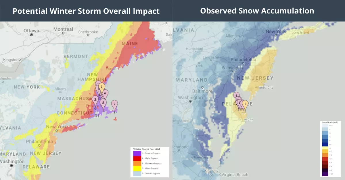
As of early Saturday, snowfall up to 15.5 inches was recorded in portions of New Jersey, with a foot at Lewes, Delaware, and just over 10 inches at Islip, New York. In the South, 6 inches of snow was measured in North Carolina. As per the NWS, winds will continue to intensify as the system tracks its path. Winds are already gusting over 30 mph in New York City and 40 mph in Boston.
Assessing the impact
EigenPrism users can access the following quick links to track Winter storm Kenan. You can immediately overlay the event footprints on your exposure:
- 1-3 Day Potential Winter Storm Overall Impact as of 2022-01-29
- 72-Hr Forecast Snow Accumulation as of 2022-01-29
- 72-Hr Observed Snow Accumulation as of 2022-01-29
- Daily Peak Wind Gust across NA for 2022-01-29
January 28 | Nor’easter Bomb Cyclone Threatens Mid-Atlantic States, New England with Heavy Snow, Winds and Flooding
A weekend nor’easter, namely, Winter storm Kenan, is likely to impact more than 55 million Americans from the Mid-Atlantic states to New England with heavy snow, dangerous winds and coastal flooding. The storm is expected to form Friday off the coast of Carolinas. Post that, it will track northward up the East Coast overnight into Saturday as it rapidly strengthens into a ‘bomb cyclone’.
As per the NWS forecasts, parts of eastern Massachusetts, including Rhode Island, and Boston can see snow between 12 to 24 inches combined with wind gusts up to 64mph. Additionally, the low-pressure system can also pose a threat of dangerous blizzard in New England, that can cause power outages and some damage in the region. The storm is likely to strengthen at a rate and intensity of the most powerful hurricanes.
The storm is likely to bring heavy snowfall and strong winds in parts of Northeast, however, the track is still not clear. The NWS issued winter storm watches and warnings for Friday night and Saturday from portions of North Carolina to Maine, including Boston, New York City, Providence, Norfolk and Philadelphia. North Carolina and southeastern Virginia could see snow up to 3 inches, and winds up to 35mph.
From Friday into Saturday, Winter storm Kenan will track towards the East Coast – where it is likely to dump snow up to 14 inches in parts of Connecticut and New York, and wind gusts up tp 55 mph. Similarly, New Jersey could see snow up to 9 inches, and winds gusts up to 50 mph.
Assessing the impact
EigenPrism users can access the following quick links to track Winter storm Kenan. You can immediately overlay the event footprints on your exposure:
- 1-3 Day Potential Winter Storm Overall Impact as of 2022-01-28
- 72-Hr Forecast Snow Accumulation as of 2022-01-28