Cat 1 Hurricane Pamela Makes Landfall Along Western Coast of Mexico
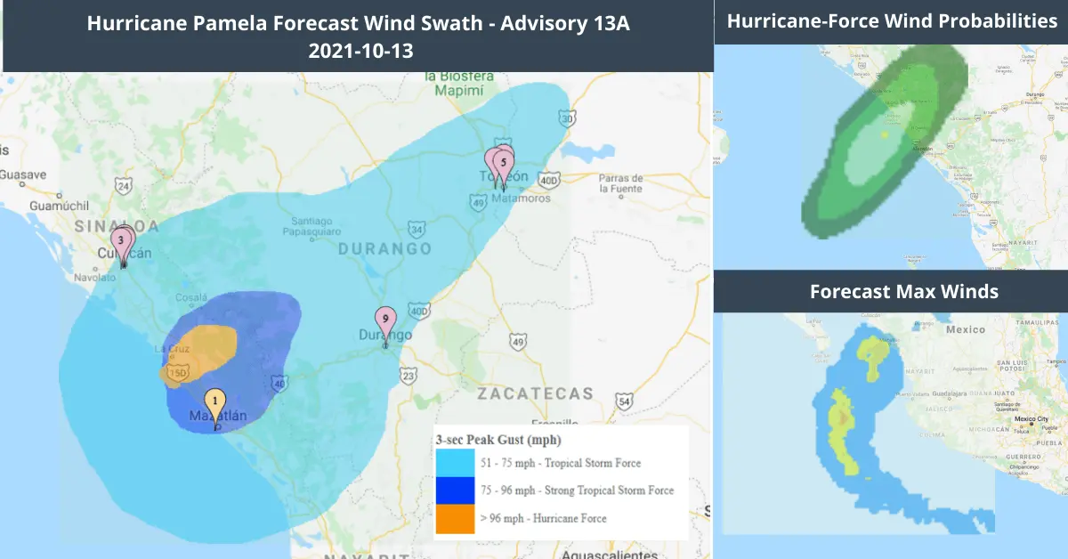
According to the National Hurricane Center, Hurricane Pamela’s landfall on Mexico’s Pacific coast on Wednesday morning caused rain and high winds to the port city. Pamela regained hurricane strength just before it hit the Western coast. The storm system was tracking just north of Mazatlan with maximum sustained winds of 75 mph at landfall.
Hurricane Pamela is currently moving northeast at 14mph. There is possibility of life-threatening storm-surges, flash floods and dangerous winds around the impact area. However, the storm is expected to quickly weaken as it moves inland, as per NHC.
Pamela is expected to weaken again while crossing over northern Mexico. Subsequently, it could approach the Texas border as a tropical depression or remnants by late Wednesday or early Thursday. The remnants of Hurricane Pamela could carry heavy rain to central Texas and southeast Oklahoma.
Follow the quick links to assess the impact of Hurricane Pamela’s Landfall in EigenPrism:
- Hurricane Pamela Forecast Wind Swath Advisory 13A – as of 2021-10-10
- Hurricane-Force (>64 kt) Wind Probabilities – from 2021-10-13 to 2021-10-18
- Hurricane Pamela 2021 5-day Forecast Max Winds at 2021-10-13
Oct 11 | Tropical Storm Pamela to Strengthen into a Major Hurricane
According to the National Hurricane Center (NHC), tropical storm Pamela formed off Mexico’s Pacific coast on Sunday evening. It will likely gain strength and turn into a major hurricane before making landfall in Mexico late Wednesday. There is a possibility of life-threatening storm surge, flash floods and dangerous winds through this week.
Currently, Pamela is located about 455 miles south-southwest of Mazatlan Mexico. It is moving west-northwest at about 8mph. The storm has maximum sustained winds of about 65 mph.
Subsequently, tropical storm Pamela will track northeast, passing close to the southern tip of the Baja California peninsula Tuesday or early Wednesday.
As per the NHC, Pamela will cross over northern Mexico and it will move through Texas on Thursday. However, as it weakens into a depression, it will bring heavy rain in the San Antonio area.
- TropStorm Pamela Forecast Wind Swath Advisory 03 – as of 2021-10-10
- Tropical-Storm-Force Wind Probabilities – from 2021-10-10 to 2021-10-15
- Hurricane-Force (>64 kt) Wind Probabilities – from 2021-10-10 to 2021-10-15